Points of Local Interest:
1. Old Man Mason's Rock
2.
The Trail Along the Lakefront
3.
Javis Migration Bird Sanctuary
4.
The Monuments Along the Lake
5.
The Real Estate East of the Drive
6.
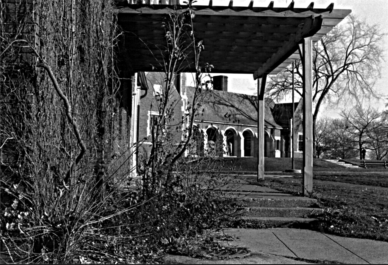
The Lincoln Park Bridle Path
7.
The Belmont Harbor Rocks
8.
The LBGTQ+ Hangout
9.
AIDS Garden Chicago
10. Lost Art on Limestone Rocks
11. The Lincoln Park Gun Club
12. The Golf Courses Along the Lakefront
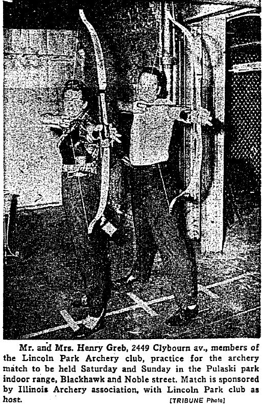
13. Lincoln Park Archery Club
14.
The Diversey Driving Range/Mini-Golf
15.
The Diversey Tennis Center
16.
The New Soccer Field

poster - Studio Chris
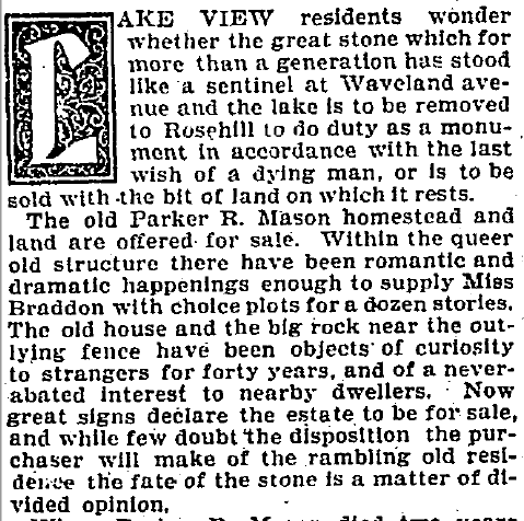
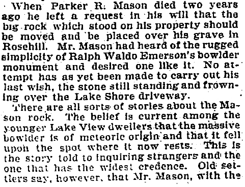
The Mason Rock
According to this 1901 article there was this mysterious meteor-sized boulder that sat on Parker R Mason's property on Waveland Avenue along the existing lake shore. As far as anyone can remember - 40 odd years, no one can remember how the rock got there and the reason for it there; but there is was sitting as if just placed their on the shoreline. Parker Mason was reported to be a odd man who apparently keep to himself and love to tinker with objects in his laboratory. He owned an illicit distillery company according to a 1876 Chicago Daily News article while owning large tracts of land in Lake View. By 1899, according to an article, he is regarded as one of the pioneer distilleries in Chicago - our very own.
This is a 1867 artist depiction of Lake View along the lakefront from a upper floor of the Lake View Hotel (Grace Street). In the distance is a house along the lakefront that may have been Mr. Mason's home. Chicago Daily News Feb 8, 1899
The Trail Along
the Lakefront
a 2011 virtual tour
image - Chicago Park District
Somewhere along the path of the park in the year 2000
University of Illinois-Chicago, City 2000
entrance or exit to our hood's trail
R.Josh via Yelp 2015
endless path along the shore
R.Josh via Yelp 2015


2016 photo - Scott Cummings
Lake Shore Drive was widen & expanded
during the years between 1936-1942
photo - University of Illinois-Chicago: Images of Change
with a 2016 Google view below
photos - Chicago Dept. of Urban Renewala then apparent parking lot along the lakefront, view northThe original Waveland Underpass is flooded
protesting a 2 dollar fee to use the courts in 1972
photo above - Calumet 412 and Carillon Tower
at Waveland Avenue
photos - Art Institute of Chicago
The fieldhouse provided park patrons with shower, locker
and rest rooms, club and craft rooms. A separate small refreshment stand
building, also designed by Edwin H. Clark, was originally operated by the
Brauer Co. While the field house was being designed, the Commissioners received
a $50,000 bequest for the carillon towner from the estate of Mrs. Annie M.
Wolforth, who died in 1926. The donation was made in memory of her husband,
Jacob A. Wolforth, member of the Chicago Board of Trade for forty years. The
Wolforths had enjoyed the chimes of a bell tower in Stockbridge, Massachusetts,
and wanted Chicago to have a similar carillon. The seven story tower was
incorporated into the fieldhouse design, and for several years the chimes were
played daily at regular intervals. This proved to be disruptive to the surrounding
community, however, and was eventually discontinued. In 1990, a group of
volunteers worked with the Chicago Park District to restore the carillon. - HMdb.org - historical marker database

photo - via Yo Chicago
Heading northeast to Waveland Clock Tower
R.Josh via Yelp 2015
photo - James S via Yelp
MEMORIES
from LakeView Historical-Facebook


Waveland Clock Tower
R.Josh via Yelp 2015
Carina Saways via Pictures of Chicago-Facebook
Tony Minard via Pictures of Chicago-Facebook
Clock Tower Cafe R. Josh via Yelp 2015
2016 photo - Manny Manotas Velez
via Pictures of Chicago-Facebook
photo via Growing up in Chicago-Facebook
the former Bridle Path east of building
photo - Wikipedia
The 1,250-square-foot facility, 3701 N. Recreation Drive,
will house a learning center, lounge and golf simulator open to all kids and
teens enrolled in First Tee throughout the year. It will also have outdoor
areas designated for putting, full-swing and short game practice. The first
phase of this project, which includes the indoor facility, is expected to be
finished in the spring with the program starting this May, said Lea Jesse, CEO
of First Tee Greater Chicago. The second phase of the project will include
building outdoor playing areas designed for putting, full-swing golf and
short-game practice, Jesse said. It was designed in collaboration with PGA Tour
player Luke Donald and golf course architects Lohmann Quitno. Construction on the project’s second phase will begin
this summer [of 2021], Jesse said. - Block Club Chicago
The Clock Works!!
the first time in decades in 2021
to my Facebook page LakeView Historical
Bill Jarvis
originally known as
Addison Street Bird Sanctuary


main entrance to the sanctuary
photo - Max Herman TimeOut Chicago
photo - Geoff Williamson, Sierra Club Field Trip
 TerraServer satellite images
 unlabeled aerial view vs labeled view
In the early 1920’s a patch of land just east and north of Belmont Yacht Harbor was still a marshy usable section of land. A sanctuary for wildlife was created during the Lincoln Park, the park expansion of the early 20th century. The park only reached to Cornelia Avenue by mid 1910's.
According to Wikipedia, Bill Jarvis Migratory Bird Sanctuary, formerly Lincoln Park Addison Migratory Bird Sanctuary. First landscaped and constructed with limited public access in the 1920’s, under the leadership of the Chicago Academy of Sciences. Most of its 7-acre (2.8 ha) area is entirely fenced around to preserve the habitat from acessive human encroachment. Instead, a nature trail and a viewing platform are at its surrounding perimeter. During the 1940’s, the park district caretakers lost funding and the site was padlocked. In 1968, the entire site was almost bulldozed for golf course development but its Lake View residents of the area, including Bill Jarvis, led a successful campaign to save and restore it. Today it hosts more than 150 species of birds, including six species of herons, like the black crowned night heron; wood ducks; woodcock; hawks; yellow-billed cuckoos; hummingbirds; thrushes; vireos; 34 species of warblers; and 18 native species of sparrows. In addition, small mammals such as rabbit, opossum, raccoon, and occasionally fox and coyote make their home there.
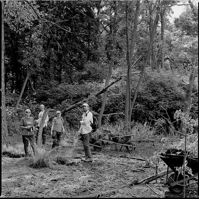
Volunteers at work 
Volunteers working the field in 2010
"With assistance from a lovely tree.
my hands were on two fallen branches
that were stuck in thick, swampy mud."
Kelly Weime photo as him as an adventurous volunteer
Depiction - Oil by Timothy Rees
The official recognition of this patch of land was not mandated until 1968 when the Chicago Park District established jurisdiction. While the CPD established ownership the sanctuary upkeep was to be managed by ecological friendly citizens of the area under the stewardship of the Lake View Citizens Council - an umbrella organization of the neighborhood civic associations in this area. As of 2001 the sanctuary was expanded to include flora and fauna collection (the word 'flora' can include flowers, bushes, trees and other plants and fauna includes birds, insects, arthropods, reptiles, amphibians and mammals). An observation platform is located on the lakeside and outside the enclosed fencing. The area was named after an advert bird-watcher and sanctuary activist Bill Jarvis.
photos - Chicago Park District
Sierra Club @ Javis observation deck - 2011
In 2009 the patrons of the sanctuary 'crossed hairs' with the city of Chicago and the Chicago 2016 Olympic Committee. The Committee was planning to install a massive tennis center next to the sanctuary. After several heated debates between residents and the city officials it was finally decided that the center would be built. Luckily, Chicago was not choosen and the peacefulness of the sanctuary was secured by the city's failure.
The Maintenance
in the Fall
typical Fall prep for Winter
photo - their web site
The Maintenance
in the Winter
Winter volunteer remove non-indigenous tree
2014 photo - DNAinfo
The Maintenance
in the Spring
photo - their website
photo - their website
an installation of a bird house
& Nature Walk of 2012
Solitary Sandpiper by KristinChicago on Flickr


Bring someone who can act as a guide for your group
Sierra Club at Javis - photo 2011
After 24 years of service to this sanctuary
she died in 2022
of other Wild Life as of 2012
According the the sanctuary's management if you plan to volunteer and help maintain the area "come prepared for clearing brush and planting seeds, and might just catch a glimpse of birds like chickadees, juncos and coopers hawks. Binoculars and instruction in how to use them will be available during break times".
Red-bellied Woodpecker
Golden Crown Kinglet
Cooper's Hawk
Northern Cardinal
The Monuments
along the Lakeshore in Lake View:
The Thunderbird
2016 photo - Judith Geisenheimer Saistone
via Picture of Chicago-Facebook
Ceremony preparing for its travel to the lakefront - 1929
Dedication of Kwanusila Totem Pole
in 1929
Dedication of Kwanusila (The Thunderbird)
1929 photo - Calumet 412 Collection
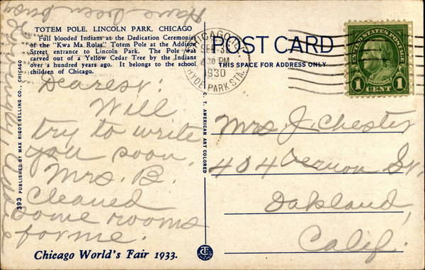
Postcard front and back 1930 postmark - Cowcard
The Background Story
Kwakiutl Totem Pole begins with the tradition of the Kwakiutl community in western British Columbia, Canada. The Kwakiutl tribe were renowned for their woodcarving skills, including not only totem poles, but also elaborately carved and painted masks. Somehow James L. Kraft, the founder of Kraft Inc.(Chicago based company) acquired a totem pole and later donated it to Chicago Park District in 1929. The pole was originally 40 feet tall and carved from a single cedar log. In 1985 the original totem pole was returned to Canada and sits in the Museum of Anthropology at the University of British Columbia in Vancouver.
The Chicago Tribune articles below tell a story of a donation to Chicago Park District that would later become an epicenter of Native American protest at this site and along the Belmont Harbor.
A Donation 1929
Vandalism in 1972
'The city was not kind to the sculptural landmark. The victim of carpenter ants, vandals, and the normal processes of weathering and decay, the Lincoln Park pole had undergone more than a dozen modifications since 1929. All of this restoration has been done under the direction of Kraft, since it was arranged at the time of presentation that the company would continue to assume the task of maintenance.
In 1958 the arm positions of the pole's human figure were changed because rotting had occurred in the arm sockets; one hand was moved so that it covered the figure's eyes. (A visitor observed that the figure no longer had to watch the spectacle of rush hour traffic which passed before it.) In 1966 the pole was drastically renovated: the sea monster at the base, the Thunderbird at the top, and the human figure were re-curved by skilled Kraft workers. Their work appears to be a faithful attempt at restoration, but the painted symbols were inaccurately reproduced. The significance of features in the original painting, which had been more elaborate, could never have been appreciated by a restorer unacquainted with Northwest Coast art. A Kraft supervisor of the restoration has suggested that Kraft workers trying to copy the intricate symbols perhaps didn't realize how important it was to duplicate features with great accuracy. The original painted symbols on the pole have almost totally disappeared.' - Living History of Illinois and Chicago
The Last Day for the Original
press photo - part of my collection
The Replacement
Its' replica like the original stands today still in the same place of the original along Lake Shore Drive north of the Belmont Harbor in front of the Jarvis Bird Sanctuary (post on this).
Note: View the post about the bird sanctuary within this blog for information on it. And check out this YouTube video on the other totem poles of North America.
The Latest Renovation as of 2017
postcard above unknown date - Ebay
OAC - Online Archives of California
It would appear that the monument was moved from the main park space to north of Diversey Harbor and east of LSD. I am guessing this move was due to reconfiguration of the park
and expansion of LSD 1936-1942
Art Institute of Chicago, Ryerson & Burnham Archives:
Archival Image Collection - SAIC Libraries

This tribute to members of the Ottawa tribe depicts a Native-American family with their dog who appear to be on alert for possible danger. The monument, built in 1884 by sculptor John J. Boyle, stands on a stretch of park on the Lake Michigan side of Lake Shore Drive parallel with Wellington Avenue. The statue was commissioned by fur trader Martin Ryerson, who worked with the Ottawa tribe. The base has granite tablets etched with Native-American scenes and a plaque with a dedication by Ryerson that reads: "To the Ottawa Nation of Indians, my early friends."
located just north of Diversey Harbor and just south of
Diversey Parkway
Art Institute of Chicago, Ryerson & Burnham Archives:
Archival Image Collection - SAIC libraries
The Dedication
in 1894
1911 postcard - Chuckman Collection
postcard - Ebay
photos - Tony Minard via Pictures of Chicago-Facebook
The Spirit of the
American Doughboy
removed to unknown location or destroyed
image - Online Archive of California
Honoring men and women who served in World War I. Erected in 1927 and removed by 1946. It was located at Lake Shore Drive parallel to Briar Place.
as it appeared in 1937
damaged prior to 1946
"In 1945, the sculpture was further vandalized, with the
face smashed in and the right arm torn off. And as if any more damage could be
inflicted on what remained of the rifle, it was bashed in on the end and
twisted down, bending the wrist. A newspaper article of the time blamed
"pacifists" for the damage. As a result, the statue was removed by
the Kiwanis Club in 1946 and possibly placed in storage somewhere."
The Real Estate
East of the Outer Drive
2901 N Lake Shore Drive
 above photo - Daily News Archives 1929
 watercolor - Ebay/artist Ralph Rapien
a 1916 Chicago Examiner ad
in 1917
by the Chicago Examiner
in 1929
by the Chicago Daily Trib
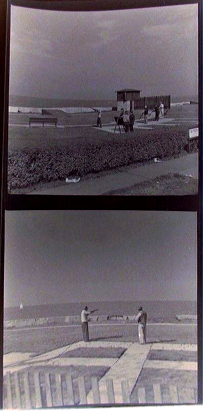
Urban Shooting in 1931negative - trap shooting 1935 - Chicago History Muesum
with more photos from the link above
History of the Gun Clubs:
Beginnings in Chicago
In the early 20th century, the elite families of Chicago built a shooting facility called the Lincoln Park Traps (LPT) on Chicago’s lakefront, where they had begun to play a new, unnamed sport. By 1918, it was common to hear the pop, pop, pop of gun fire on the lakefront, the sound of which was muffled by the big lake that absorbed and deadened the explosive sound of firing.
Chicagoans of all backgrounds enjoyed this sport that was started by Charles E. Davies, an avid grouse hunter, who invented a shooting game in 1915 using live pigeons. During the next decade, the game evolved and clay targets were used instead of pigeons. In 1926, a contest was held to name the Davies new rifle sport. Gertrude Hurlbutt won the contest with the name “Skeet,” which is derived from the Scandinavian word for shoot. By the 1940's, Skeet was used by the U.S. military to teach novice gunners the principle of leading and timing flying targets. The Lincoln Park Traps was formed by the upper class of Chicago society. As the years went by, the LPT became a public entity and evolved into a very egalitarian facility. Everyone was welcome to shoot at Lincoln Park Traps, and it was common for Chicago’s plumbers and carpenters to shoot Skeet next to the city’s elite. The Lincoln Trap and Sheet Club was established in 1923 and incorporated on February 25, 1967 as the
Lincoln Rifle Club and Junior Division, Inc., a registered, non-profit organization. Since December of 1926, the LRC has been a proud active member of the National Rifle Association (NRA) with 100% of members belonging to the NRA.
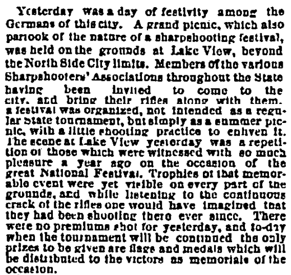
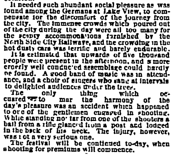
But even before that time period German-Americans from Chicago traveled north to Wright Grove Woods as early as 1867 to enjoy the lively sport of sharp-shooting just north of the Chicago border (Fullerton Avenue) and within Lake View Township per this article.
Sharpshooters and Picnics at Wright Wood Grove
by 1867
between of Diversey & Fullerton near the lakefront
The Art of Skeeting
1933 text -Chicagoan
photo - Craigs Lost Chicago
photos - Calumet 412
shooting toward the lake
photo below - A Place for Us LGBTQ Life at Belmont Rocks
the veiw from the Belmont Harbor Rocks
a 1940 article belowfrom Benjamin Yolarski
via 'Chicagoland Before We Were Born' - Facebook
mid 20th century negatives below - Ebay photos below - Chicago History Museum
photo below - Tom Morrissey via Forgotten Chicago-Facebook
It was Fun & Easy
but Costly in 1964

The Illinois Environmental Protection Agency sent us a letter saying it appears the Lincoln Park gun club was violating the law," says Nancy Kaszak, general counsel for the Chicago Park District, which owns the property on which the gun club operated, but not the private club. We did some investigation and came to the conclusion that the gun club was, in fact, violating eight statutes. They were, and are, shooting lead into the lake, and as a result, the Park District could be held liable." Kaszak recommended that if the gun club couldn't satisfy the legal requirements--which, apparently, it cannot--the Park District should evict it from its current site near the intersection of Diversey Parkway and Lake Shore Drive. The Park District's five board members agreed, and on September 14 they unanimously adopted a resolution that could shut the club sometime after January 1, 1989. "The weapon is a shotgun; it uses a shotgun shell. The powder in the shell is separated from the lead shot by wadding and contained within a casing. When you shoot the shotgun, it propels the shot out toward the clay pigeon; as part of that process, the wadding can be thrown out of the shell as well." Bathers and boaters frequently complain of shell waddings washing up on beaches and docks, Park District officials say. At least 400 tons of lead have settled on the lake bed just east of the gun club, not to mention the remnants of hundreds of thousands of clay pigeons. "We tested the clay pigeons and found traces of antimony, arsenic, nickel, lead, zinc, silver, and chromium in them," says Kaszak. "Now, I'm no environmental expert. But I am a lawyer. It is my job to protect the Park District against liability." - Reader newspaper photo below - Joseph Schlesinger
via Forgotten Chicago-Facebook
Shortly after the opening of Belmont Yacht Harbor the city began to develop the North Lake Shore Drive from Cornelia to Montrose Avenue with real estate that included the Waveland Park space.
photos below - Art Institute of Chicago
Waveland Clock Tower unknown date
The Ice Rink
in 1941
Sydney R. Marovitz Field House and Golf Course
(still referred to as Waveland Golf Course by locals)
photo Flickr contributor Duane Rapp
photo above - Yo Chicago
Sydney R. Marovitz Golf Course - Karen Thall

The Gateway
to the former Bridle Path
2 photos - Ruth Sackheim
The running path beyond this gate
once used for horse riding in the mid-century
east of the Waveland Clock Tower
The path once had issues before 2012 - erosion
photo - Alderman Cappleman's 46th ward website
2015 photo - Sydney Marovitz Golf Course-Facebook
2019 photos - Paul Otto via Forgotten Chicago-Facebook
a 2010 photo below from
Patrick Gainer, Living History of Illinois and Chicago
illustration - Chicago Cityscape
The Waveland
Tennis Courts
The Pro's Clinic
in 1948
A Night View
in 1973
Snow in April
in 1975
1975 press photo - part of my collection
The Lights are On
in 1975
1975 photo - Ebayzoomed below The Lincoln Park
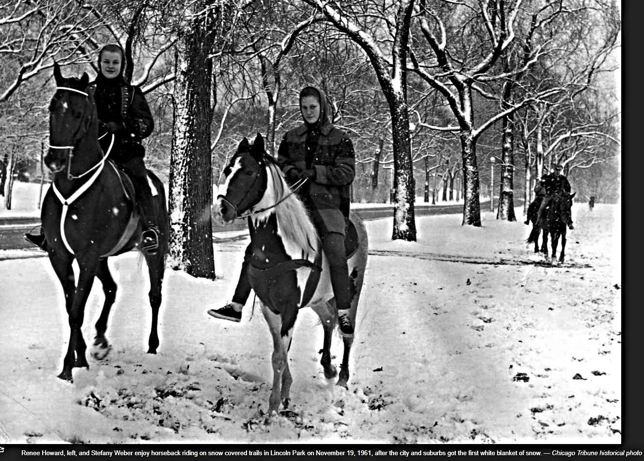
Bridle Path
"It was extremely popular in the 40's and 50's. Many of Chicago's elite boarded their horses there and there were many horse shows held there each year. There was an entry into the park and every Sunday morning there would be breakfast rides by riders who would be in formal dress as they trotted around the bridle path."
- nancybc via Forgotten Chicago
1945 photo - Calumet 412
The runners path through the park were originally routes for equestrians either owners of a horse or rented one. By the end of the 20th century most of the paths had been paved over for the bike rider or runner so to reduce erosion and the number puddles. There were several horse stables along Lincoln Park - the park. Equestrians academies & stables dotted the lakefront landscape supported by shops in Lake View area that supplied equipment for the sport - one type shop was located on the 4425 N Broadway Avenue and the other on 4606 N Sheridan Road both called The Swiss Shop.
The construction of yacht harbors were important attractions for the equestrians. Equestrians would stop at a clubhouse in the harbor area to rest or chat - maybe enjoy a meal or drink either for their horse or for themselves. An association was established in 1908 in Chicago so to create the 'rules of the road'; the proper use of the sport.
the value of the sport for the rider
the value of the sport for the horse
Map of Lincoln Park District 1921 - p.61
Schools & Academies - insert
Lascot Riding School, 75 E. Walton Place
First Cavalry Riding Academy, 1330 N Clark Street
Parkway Riding Academy, 2153 N Clark Street
Pemberton Sales Stables (No horses for hire)
No location/telephone not mentioned
North Shore Riding Academy, 2822 N Clark Street
Lincoln Riding Academy, 3008 N Clark Street
telephone Wellington 4060
Edgewater Riding Academy on Foster Avenue
Catalpa Riding Club (private), 1124 Catalpa Street
No telephone mentioned (No horses for hire)
Birchwood Country Club, Devon Avenue
No telephone mentioned (No horses for hire)
North Shore Polo Club, Lincoln & Peterson Avenue
plans for a landbased clubhouse in Belmont Harbor
harbor was opened to the public by 1916
an advertisement within the booklet for Parkway p. 89
and supply stores p.18
a testimonial
'murphman' via Forgotten Chicago 2013
"Growing up in Lake View in the seventies, I recall a young woman who rode a horse around the neighborhood - was a strange sight. She was very friendly and allowed us kids to pet the horse. Also I seem to remember she rode bareback. Doubt if you would see that today!"
Horses once roamed the lakefront from at least 22 stables from Hyde Park to Foster Avenue. The nearest to the neighborhood of Lake View was the 'New Pathway Stables' that was apparently established in the 1890's and closed in 1967 due to changing population attitude toward horseback riding. Apparently, the newer residents did not have the means to own or ride a horse along with the sanitation concerns in a densely urban area. According to Bob Hughes of the Chicago Tribune "the Chicago Park District insisted that commercial activities were not allowed in the parks and emphasized that if a nonprofit stable were to be approved, it would have to meet 'high sanitary and structural standards'. Just how high those standards would be was not specified, but it seemed likely that even a good jumping horse might find them formidable."
1937196119661974The Noble Horse Company on Orleans Street was built as a
stable in 1871 and renovated in 1922 to include a riding academy. In 1997,
developers wanted to buy the land and move the stable out. Monica Rauschenbach,
the manager and horse owner, brushes out her horse, Odie on May 14, 1997. Noble
Horse Co. was the last riding stable in Chicago and now is operated as Noble
Horse Theatre. - Bill Hogan, Chicago Tribune
New Parkway Riding Stables, was once located at 2153 N Clark Street, furnished horses for rides in the park and taught classes. This stable had been in business since the 1890's and still sent out some 600 riders every weekend to Lincoln Park in 1966. New Parkway was the last publicly used a city-operated stable. It closed in October, 1967.
Testimony via 'Forgotten Chicago' 2011
I rode at the New Parkway Stables in '52 at Webster and Clark. Owner was Johnny Klein and instructors were Ivan Parks and Peggy Drummond who was also Chicago school teacher. I originally began at Christensen stables south of Clark and North avenue in a former auto dealership building. It was the west side of the street down from the Red Star Inn. Beginners learned in the inside ring and advanced folks went into the huge larger inside arena in the area where there once had been cars and carriages. The great, now deceased, famous Saddlebred trainer, Tommy Moore worked there as a teen and everyone at that time marveled at his talent. ‘Ambassador Stables’ was east of this barn and the entrance was off an alley; very small barn with few riders most of whom came from the affluent Gold Coast area. The fourth barn was ‘Plush’ just west of New Parkway off of Grant Place. Nice barn, big ring but long walk to the entrance of the zoo which got us to the bridle path along the Lincoln Park [lagoon]. What a thrill to attract all that attention from zoo visitors as many as 40 of us would walk thru the zoo. Sunday breakfast rides meal was taken at the Black something restaurant at Clark and Diversey; most of the riders were older women. Fifty-four horses in straight stalls were in the basement of the Parkway. On the second floor were the private horses owned by people from the Stewart Coffee family and others in box stalls. There was a fire in the basement of Parkway around '55 or so and only one of the 52 survived...the oldest school horse they had simply dipped his nose deep into his food trough and survived. They had to pull all the horses out of the basement through the windows and ramp and they were piled up in the alley. - MollyGo via Forgotten Chicago
Stables vs Citizen Groups 1954
page 2
The Last North Side Stable Closes 1967
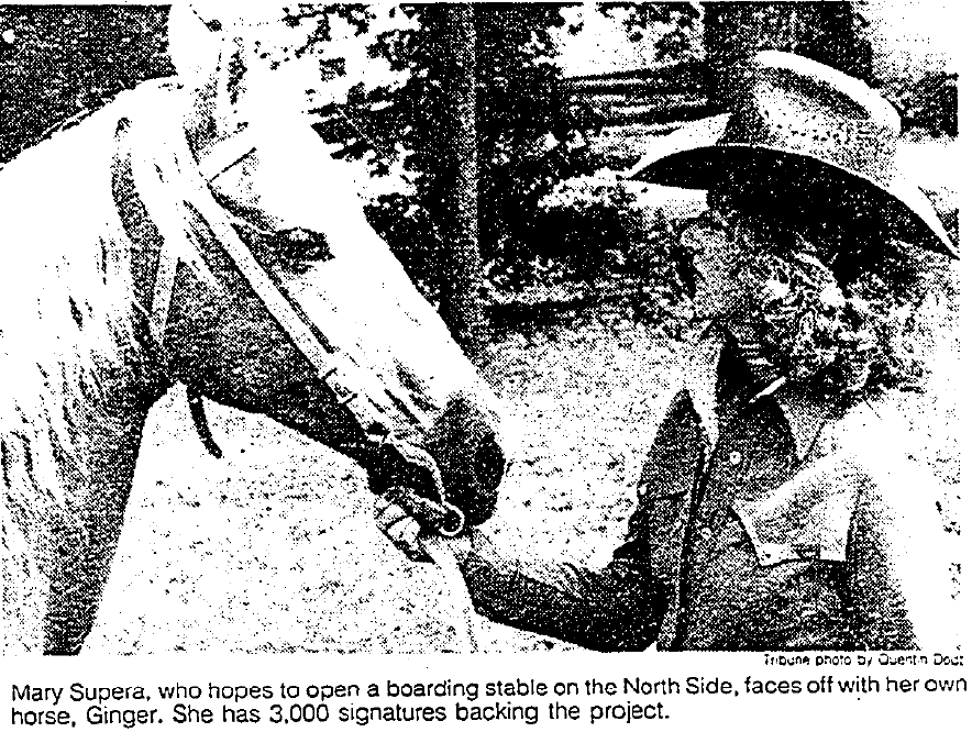
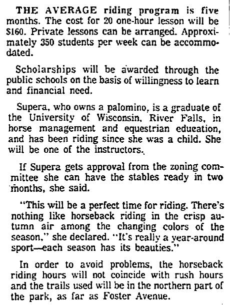
A Return to Lincoln Park??
in 1979
Runners won - Horses lost
Photos of that Path
in 2012
running toward the Barry Avenue underpass
The Rocks
near Belmont Harbor
This sign blanketed the area along the lakefront between Diversey and Belmont Harbor on what was commonly known simply by the locals as the 'Rocks'.
In 1910, the construction of the existing shoreline
protection structures began. From 1910 to 1931, the shoreline protection structures were built along the
lakefront from the north side of the city to the south.
Chicago Tribune view of the 'Rocks' in 1972
Join the conversation on Forgotten Chicago on Facebook
Richard Wingstrom via Forgotten Chicago-Facebook
north of the Belmont Point looking south in 1987
The shoreline and the waves of Lake Michigan, particularly after storms, became an issue by the turn of the 20th century when Lincoln Park Commission, an a administrative authority, began to expand and extend the originally box sized park northward along the existing lakefront. Below is an article for the Chicago Tribune about the damage caused my the lake to the then unprotected lakefront.
The Water Fight with the Lake
in 1901
"Again, like many times before, the Chicago's shoreline was threatened in the 1980's by high lake water levels that during storms closed North Lake Shore Drive. The Chicago Park District, the Army Corps of Engineers and the City of Chicago developed a plan to rebuild the limestone step revetment along the lakefront. They signed a Memorandum of Agreement in accordance with the Secretary of the Interior's Standards to ensure that the project would protect the historic value of the structure. However, when construction actually began in the 1990's the public was appalled -- long unrelieved stretches of steel and concrete where the historic limestone had been. After all but two sections of the lakefront had been ruined -- Promontory Point and Diversey-Wellington -- the Illinois Historic Preservation Agency halted the project. But in July of 2006 the IHPA, under by a riptide of political pressure, endorsed the concrete and steel reconstruction." - Preservation Chicago
The Shoreline Protection Project
The old limestone blocks that line the edge of the lake will be replaced by new concrete stones in that area as a part of the Chicago Park District’s eight-mile lakefront revetment plan. The park district and its project partners said the revetment – a renovation to protect the embankment – is necessary to prevent further lakeshore deterioration. Not everyone in the community is happy about the changes, however. South East Lake View Neighbors Vice President Robert Clarke said the majority of people at community meetings said they did not want the changes. “We accept the need to rebuild the revetment; we just challenge the design and the materials. That’s the essential issue,” Clarke said.
- Medill Reports Chicago
The northern half of the lakefront stretch between Diversey and Belmont is scheduled to be under construction beginning in May 2002, as part of the city’s Shoreline Protection Project, which in that particular area consists of the reconstruction of 3,300 linear feet of shoreline. Improvements will include the construction of the step stone revetment at an estimated cost of $19 million, according to the city’s Web site. Construction is expected to be completed in 2003.
- from the newspaper Skyline
postcard of shoreline
along the Gold Coast - 1940ish?
Chicago's existing shoreline protection was built between 1910 and 1931. Known as revetments, the shoreline protection comprised of wood pile cribs filled with stones in the shape of steps. In the 1950's, the wood piles began collapsing, leaving shoreline protection structures and park land to erode and wash away. In 1964, the year when Chicago recorded the all-time lowest water levels on Lake Michigan, the wood piles became exposed and started rotting, further increasing the erosion process. Due to their age and deteriorated condition, these structures no longer provide adequate protection for Lake Shore Drive, a federal highway adjacent to this shoreline, and other public facilities. This threat of damage prompted Congress in 1974 to direct the U.S. Army Corps of Engineers to investigate these and related erosion problems along the entire Illinois Lake Michigan shoreline - City of Chicago
photo - Chicago History Museum
Laying the out the artificial shoreline along
Lincoln Park at Montrose Harbor area in 1929
1949 negative below - Ebay
The Icy Rocks in 1968
Fishing in 1969
photographer Alex Fradkin
UIC via Explore Chicago Collection
and now ...parallel to Barry Street by Kristen Hidinger via Pinterest
and to remembered with the .....
As cooperating agencies, the City of Chicago and the
Chicago Park District worked with the Chicago District Army Corps of Engineers
on the Feasibility Study which was used to determine that Federal assistance
should be provided to protect the shores of Lake Michigan from future storm
damage and erosion. The final Feasibility Report and recommended plan for
reconstruction was presented by the Army Corps of Engineers to Congress in
1994. From this report, the eight most critical miles of the lakefront were designated
for reconstruction.
The project areas are broken up into "reaches,"
each reach encompassing different sections of the shoreline. They are:
Reach 2-step stone revetment reconstruction in the area
from Montrose to Fullerton Avenue
Reach 2F-breakwater and beach nourishment at Fullerton
Avenue to prevent flooding of the Fullerton Avenue exit and entrance ramps to
Lake Shore Drive
Reach 3-step stone revetment reconstruction at Solidarity
Drive
Reach 3M-revetment reconstruction along east and south
sides of the apron of Meigs Field Airport
Reach 4-step stone revetment reconstruction from 23rd
Street to 57th Street alongside Lake Shore Drive
Reach 5-breakwater reconstruction protecting the South
Water Purification Plant

The Belmont to
Diversey South project consists of the reconstruction of 1,100 linear feet
of shoreline. Improvements will include the construction of
steel sheet pile and concrete revetment, use of IHPA-approved concrete texture formliners,
drainage and landscaping improvements, and a raised toe berm. Reuse of the community dubbed
“art-stone” as a landscaping/architectural detail is under evaluation. The construction cost of this
project was $11.1 million. Contracts on this project was administered by USACE. The ITR was completed on 23 April 2002 and
construction was completed in 2008.
The Irving Park
Road to Belmont Avenue project consisted of the reconstruction of 4,000
linear feet of shoreline. Improvements include the construction of
steel sheet pile and concrete revetment. Contracts on this project were administered by USACE. The
construction cost of the project was $15.6 million and was completed in summer 2002. The ITR
was completed on 4 August 1999 and construction was completed in 2001.
The Belmont Harbor
Peninsula project consisted of the reconstruction of 1,000 linear feet of shoreline. Improvements included the construction of
steel sheet pile and concrete revetment. The construction cost of this project was $5 million.
Contracts on this project were administered by the DOT and CPD. The project was completed in 1999.
The Belmont to
Diversey North project consists of the reconstruction of 1,700 linear feet
of shoreline. The contract on this project was administered
by USACE. The construction cost of the project was $10.5 million and was completed in summer
2004.
The Diversey to
Fullerton project consisted of the reconstruction of 2,300 linear feet of
shoreline. Improvements included the construction of steel sheet
pile and concrete revetment, new park creation by land expansion into the Lake, a new lakefront
trail, and landscaping and drainage improvements. The construction cost of this project was
$17.2 million. The contract on this project was administered by USACE. Construction was
completed in July 2005.
the Addison Avenue section of the Rocks in 1987
by Richard Wingstrom via Vanished Chicago-Facebook
photos below - Skyline Newspapers
Opposition
The main issue in 2001 was the sometime violent impact of
the waves along the shoreline. The question would be, is it better that waves
hit the shoreline naturally or artificially during violent weather? The view
from the citizens and neighborhood associations were tat the 'rocks' provide less of an
aggressive impact to the shoreline while providing a more natural
configuration. The limestone blocks that adorned over the countless decades
were, according to some community residents, the art and poetry of the
community.
photos - Illinois Construction Corporation
Parallel to Belmont Avenue
2018 photo - Joe Roels via Pictures of Chicago-Facebook
2021 photos below - Garry Albrecht
a blend of natural and manicured placements
view near Diversey Harbor
declined pathways to the waters edgeWill the artwork return? 'A Place for Us: LGBTQ Life at the Belmont Rocks'
on Facebook 


“I recall that the early 1990's was a tumultuous time for gay men and women. Friends and acquaintances were dying from AIDS. Many of us were "OUT" to family and friends but not necessarily at work,” Brotebeck added. “We were finding our identity, strength, resilience, independence and confidence while still battling the homophobia of the outside world. I believe “THE ROCKS” is a perfect metaphor for the men we became despite the obstacles that existed within the gay community during those days.” - Chicago Tribune
Many of the photos below are from a Facebook page
photos - Doug Ischar
View more adult photos from the photographer Doug Ischar
This gay gathering place was yards away from a rifle range just south of the so-called 'gay rocks'. I was told that the ‘standing joke’ at the time was whenever a rifle shot was fired some ‘gay’ sunbather would scream out to the others while basking in the sun, “They missed another faggot again” that would be followed with a recognized smurk or momentary chuckle.
photo - A Place for Us LGBTQ Life at the Belmont Rocks
photo below - Alan Light
'The Rocks' had its own Pride Parade Float in 1985
along the Rocks
located in Lincoln Park at Barry & Lake Shore Drive
and near the Belmont Harbor parking lot
2018 Google Map view
The mission of the AIDS Garden Chicago is to create and maintain a garden space for reflection and education about the AIDS Epidemic. The Garden honors those that have passed and those that have survived, and celebrates the heroes of the AIDS Epidemic and their ongoing work to eradicate HIV/AIDS.The AIDS Garden will be built along the Belmont Rocks, a space the gay community would gather at since the early days of Chicago's LGBT movement. The Rocks were about claiming the right to be, to exist, to gather outside and to be out of the shadows and the closet. - AIDS Garden Chicago


photos - AIDS Garden Chicago
The AIDS Garden seeks to help preserve that memory and to honor the history of HIV/AIDS in Chicago. It is fitting to create a garden in that Belmont Rocks space. Since the early days of gay movement, the Belmont Rocks were a place to call our own. The lakefront stretch of stone and grass from Belmont to Diversey harbors was a public space Chicago’s LGBTQ community claimed from the 1960's through the 1990's. This was more than a frequented area. The Rocks were a political statement tied to our liberation, a symbol of our right to be here, our right to exist, and our right to gather outside and in the sunlight at a time when our bars still had blackened windows. Community happened along this undesirable strip of uneven limestone blocks. Relationships and friendships happened here, hook-ups, unions, memorials, picnics, cookouts, dance parties, and rallies. Artwork covered many of these stones. At the Rocks, people lay in the sun, watched the sunset before going out, and sat to watch the sunrise after the bars closed. In 2003 the Belmont Rocks were bulldozed and removed as part of a revetment project to safeguard against shoreline erosion. The Rocks themselves may be gone, but this portion of the Chicago shoreline will forever remain a place of celebration, joy, and remembrance in the pre-AIDS era and the throughout darkest days of the epidemic.' - AIDS Garden Chicago
2022 above photo - Jonathan Pizer
2022 below photo - Steve Brodwolf
photo via Owen Keehen
on the Rocks
Remember the ‘rocks’ along the lakeshore; those chucks of limestone cubes that once graced the man-made shores of Lake Michigan? Well, while those cubes of limestone have been removed from the lakefront landscape the man-made artwork carved in those limestone cubes have not been forgotten thanks to a Chicagoan named William Swislow. Chicago's lakefront art represented an important,
beautiful body of work. While uniquely urban, it resonates with petroglyphs
more typically associated with antiquity or back-country settings. It is as
valuable a cultural legacy in its way as any in the city, and if there are no
changes in plans, most of it will survive only in photos from the link above. It's ironic that these artistic treasures were part of the
city's best-known amenity, the lakefront. Aron
Packer had exhibited his photos of the work, written about it, and given
walking tours, but his efforts amount to the only apparent public recognition.
Hundreds of thousands of people picnic, sun and stroll by the lake, but it's
doubtful that more than a few have noticed what they sit or step on. - Interesting Ideas.com

William Swislow had an idea! He was aware of the artwork created on those cubes. He thought before the limestones were to be removed from the landscape he thought to preserve it with photography and post them on his own website. With this task, he helped preserve the now lost art of Chicagoans who patronized the lakefront and created art of various forms and shapes beyond the graffiti we most often remember ... to a time when man first created art in caves. My thanks to Allen Anthony Maniscalco for posting a link to Mr. Swislow's site on Forgotten Chicago-Facebook. Below are some samples and his website telling his story along with the other photos not to be forgotten from the artists that created them.
And then there
was this other type of artwork
At the edge of the harbor towards the entrance a object made of concrete was created by a local artist late 1970's or early 80's. Like the Mason Rock no one for sure when it appeared or disappeared.
The Golf Courses
Along the Lakefront:
from a beach to a golf course to driving range & mini course
postcard - unknown date & source
this postcard does not show a connecting bridge
for the Outer Drive at Diversey Harbor
1933 photo - Chicago Park District via Jeff Nichols,
Forgotten Chicago-Facebook
1936 IDOT photo of the area near the Diversey Harbor
before the Lake Shore Drive WPA project
photo - University of Illinois-Chicago: Images of Change
when Lake Shore Drive was widen & expanded
during the years between 1936-1942
a 2016 aerial view - Google Earth
Bathing Beach was filled-in for Golf Course in 1922
Photos of former 'Bathing Beach'
photos- Chicago History Museum
via Explore Chicago Collection
Plans for Expansion of Lincoln Park in 1894
The Diversey Avenue Street End-Beach
as of 1903
Beach Space from Fullerton Avenue
to Diversey Boulevard in 1910
The Nine Hole Course
by 1931
a 1936 post mark postcard view - Ebay
The Property Reduced
by 1942

formerly known as
Waveland Golf Course
3600 N Recreation Drive
and the view when it openned in 1932 below photo - Chicagology
According to an article from Urban Matter, "back in 1929, the city started a three-year-long project to build a golf course on the lake. When costs started to build up, funding (unfortunately) didn’t. This led to half of the holes being built as planned, all of which run parallel to the lake. It’s construction finished in 1932, and the course opened to the Uptown Community with the name Waveland Golf Course." Note: While the bulk of the course lies in Uptown the legal address is in Lake View, hence part of Lake View's history. About the name Change Sydney Marovitz was a commissioner - not even the
chairman - of the Park District Board from 1974 to 1986 during the discredited
reign of former Supt. Ed Kelly. He is said to have been a kind, compassionate
and thoughtful man, though not one who left much of a mark on the parks. The last name, however, may ring a bell. Sydney's
brother, Abraham Lincoln Marovitz, is a senior federal judge from Chicago who
has administered the mayoral oath of office to both Richard M. Daley (who
installed Claypool and Rogers) and his father, Richard J. Daley. Sydney's son,
William, was a veteran Democratic state senator from the North Side at the time
the new name was approved. The renaming of Waveland reeked of backroom politics,
nods and winks, connections, deals and arrogance born of the disregard for the
public will -- hallmarks of the old era. And an interesting thing has happened since. Chicago-area
golfers, in an unorganized but widespread expression of civil disobedience,
have refused to adopt the new name. "No one uses it," said Henry Hauser, president
of the Lincoln Park Golf Club, a group of amateurs that regularly plays the
course. "I've never heard anyone say, 'We're going to play Marovitz.' It
just doesn't fit." "This is Waveland, that's it," said Esther
Dunn, a golfer who was sitting with Hauser earlier this week at a table outside
the course restaurant, which has kept the name Waveland Cafe. Over by the first tee, Scott Stiller, 23, who never
played the course until after it was rededicated, said he also only refers to
it as Waveland. "I don't even know who Sydney R. Marovitch is,"
he said, butchering the name slightly. "Was he a good golfer? "We'll always call it Waveland," said Glen
Priester, 73, as he put his clubs back in the car over in the parking lot.
"It's easier to spell and pronounce and remember."
Oppostion Even in 1930
since 1925
photo - photographer Katie-Carrillo-Majeweski
pre 2019 photo - Google Maps Century of Progress location
 in 1933Hosting in 1962
current photos - their website photos below - North Side Archery Club
The Diversey Avenue
Driving Range
2016 image - Google Earth
2000 photos - University of Illinois-Chicago, City 2000
The Mini Golf Course
signed by Ernie Banks 1976 - Ebay
1976 photo below - University of Illinois-Chicago
via Explore Chicago
The Chicago Park District was planning a new playlot by the Lincoln Park Driving Range just east of the miniature golf course. The community will select their choice to the district.
all photos - 44th city ward office
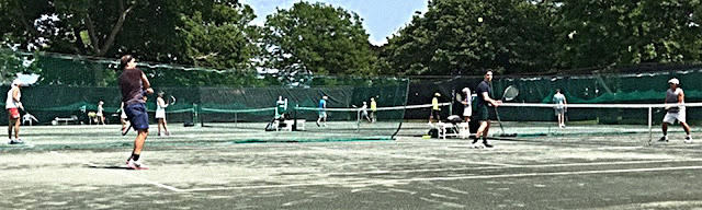
Diversey Avenue
Tennis Center
The only tennis court left in Chicago with a clay playing field
an aerial view
 A Proposed
 Soccer Field
in 2020
'This new field will feature a full sized field, minimally
sized bleachers and easy access to parking at the existing parking lot. This is
part of a larger project which will include correcting drainage issues in
adjoining areas of Lincoln Park and adding naturalized areas near the Barry
underpass. In addition to hosting practices for Lincoln Park High School
sports, the field will be available to the community at all other times.' - per 44th ward office
edited Google Earth view below
No Post Notes
Please Follow me to my Next Post Called
These posts are exclusively used for educational purposes. I do not wish to gain monetary profit from this blog nor should anyone else without permission for the original source - thanks!


.jpg)


 TerraServer satellite images


 above photo - Daily News Archives 1929


.jpg)
.jpg)
%20(2).jpg)
%20(1).jpg)


 Century of Progress location


No comments:
Post a Comment