My Perspective
of Lake View
by Garry Albrecht
This post contains lot of photos of the Community of Lake View, events that shaped the Community of Lake View. the Neighborhood Associations, as well as vintage articles that may help the reader understand my view of my northside community of Chicago.

photo - Lake View Patch
Broadway near Grace/Halsted

poster by Studio Chris


2014 highlights of neighborhood by
Moore Chicago Art

Moore Chicago Art above

2023 photo - My America/Facebook
2010 photo below - Chicago's Lake Shore Drive
by Neal Simors & Beranrd Judge

An aerial photo below as of 2021
by Rolando Moreira
that highlights the Belmont Bypass CTA Project
with a view north to northwest

1869 Map of Lake View Township
The township was established in 1857
& incorperated in 1864
The township 1857-1887 ranged from Devon Avenue (Church Street) to the north and Fullerton Avenue (Road) to the south; Western Avenue (Northwood Avenue) to the west to the then exiting lakefront to the east. Landfill for the northward extension of Lincoln Park, the park would not begin
until the turn of the 20th century.
Also, the voters of the township voted to change the governmental status from a township to a city 1887-1889 while not changing its territory.
More on Old Lake View in my other blog posts.


Community of Lake View
map - Etsy

The decrease of the geographical size of the Lake View occured when offical Communities were established by the City of Chicago by early 1930's.
After the annexation of Lake View in 1889 the City of Lake View was referred as a District within the City of Chicago.

artwork - John Fluent Art
Some Marketing
Videos


Aerial Photos
by Jacob Hill in 2019

view south and view northwest

and finally a view west at Belmont Harbor

Various Other
Photographers Below

Chris Cullen Photography

2016 photo from a helicopter - Bobby Blinner
via Pictures of Chicago-Facebook

Mike Mitchell via Pictures of Chicago-Facebook

Jim Jasiota via Living History of Illinois & Chicago -Facebook

2018 photo - Greg Moorehead

Chevon - photo by Sian Erten

Mike Mitchell via Pictures of Chicago-Facebook
with the Chevon sculpture in the background

From the Belmont L - Lake View Patch

Clark & Halsted - Chris Cullen
via Pictures of Chicago -Facebook

along Broadway
photo - Chris Cullen via Original Chicago-Facebook

photo - Chicagoland-Facebook

waiting for a train - People on the CTA-Facebook

view of the neighborhood along with the Blue Angels
Chris Cullen Photography 2017

Ndine Vincent via Original Chicago-Facebook


Raymond Kunst Fine Art Photography
and then in the Winter months ...

Arlyn Mena via Original Chicago/Facebook in 2019


Sunset by Dave Gelfand 2021

February 2021 photo - WatchMarquee/Twitter

photo - Boystown-Facebook

along Clark Street north of Roscoe Street
Chris Cullen via Pictures of Chicago-Facebook 2016

2017 photo - Chris Cullen - Oakdale Avenue

2018 photo - Chris Cullen - Oakdale Avenue

2018 photo - Chris Cullen - Oakdale Avenue

next to the Brewster Apartments
2019 photo - Chris Cullen via Picture of Chicago-Facebook
2018 photo - Chicago Transit Authority-Facebook

Raymond Kunst - Fine Art Photography

Raymond Kunst - Fine Art Photography

photo - Gregg Moreland

2018 photo - Southport Corridor News & Events

2018 photo - J Scott Sykora
via Pictures of Chicago-Facebook

photo - Chris Cullen Picture of Chicago-Facebook

Chris Cullen via Pictures of Chicago-Facebook
The Seasons building along Broadway

Chris Cullen via Pictures of Chicago-Facebook
corner of Southport & Belmont Avenue

photos - Lake View Roscoe Chamber of Commerce


David Caballero via Forgotten Chicago-Facebook

and its marker ...

photos - Chris Cullen via Pictures of Chicago-Facebook

photo - Gregg Morehead via Pictures of Chicago-Facebook

photo - John Hohenade via Pictures of Chicago-Facebook

photo - Greg Moorehead

Chris Cullen via Pictures of Chicago-Facebook

Chris Cullen via Pictures of Chicago-Facebook

Chris Cullen via Pictures of Chicago-Facebook

Raymond Kunst - Fine Art Photography

Emanuel Torres

Raymond Kunst - Fine Art Photography
The New York Private Residences

photo - Gonzalo Alfredo Escobar

The New York Private Residences by Chris Cullen

Chris Cullen Photography

Lincoln/Racine/Diversey
Chris Cullen Photography

along Paulina Avenue
Carina Sawaya, Pictures of Chicago-Facebook

photo - Lake View Patch

photo - Greg Moorehead via Original Chicago-Facebook

Alta Vista - Chris Cullen

Greg Moorehead via Picture of Chicago-Facebook
below photo - Xavier Quintana-Pictures of Chicago-Facebook

More Photos Later ....
but for now
A Deep Historical Dive:
It Began as a Township &
then a City
and then a District
and then finally
one the the 77 Communities
within the City of Chicago

map - Illinois Genealogy Trails
The North/West/South areas in the map above were originally townships that the city of Chicago annexed by the mid 1800's.
Some Definitions & Background
A township is a widely used unit of local government, particular east of the Mississippi River, subordinate to, and geographic divisions of, a county (Cook for us) within given state. The specific responsibilities and the degree of autonomy vary based on each state. Civil townships are distinct from survey townships, but in states that have both, the boundaries often coincide with one another. The U.S. Census Bureau classifies civil townships (called "towns" in New England, New York and Wisconsin) as minor civil divisions. When reading articles in my blog posts notice that 'town' refers to the word 'township' by a newspaper.
A township governmental functions are generally attended to by an elected governing board (the name varies from state to state) and a clerk or trustee. Township officers once frequently include the justice of the peace, road commissioner, assessor, constable, and surveyor.

wikipedia commons
Today, Illinois townships are charged with three basic functions:
1) general assistance for the indigent; 2) the assessment of real property for the basis of local taxation; and 3) maintenance of all roads and bridges outside federal, state, and other local jurisdiction. Beyond the three mandated services township government provides other vital services. This may include senior citizens programs, youth programs, assistance to the disabled, parks and recreational facilities, health services, and cemetery maintenance. Township government can serve its population from the cradle to the grave within the direct authority of their State government. In the 20th century many townships also added a township administrator or supervisor to their governing board.
Today, the township governments maintain over 71k miles of roads in Illinois or 53% of all roadways as of 2010.
The Lake View Settlement
by A.T. Andreas 1884


One of the most noteworthy events in the history of the town[ship] was the opening of the Lake View House on the 4th of July 1854. It was situated and is still standing south of Graceland Avenue on the lake shore. The hotel was built by James H Rees and Elisha E Hundley and was intended to be the nucleus of a settlement. It was a three story wooden structure of generous proportions and its’ opening was made the occasion of a grand jubilee and dinner. There were present many of the brilliant men of Chicago speeches were made and everything passed off smoothly and with joy. The hotel was rapidly filled principally by cholera refugees from the city.
As the projectors of the Lake View House [had] intended in the vicinity of the hotel a number of fine residences were erected among others those of S B Chase, S H Kerfoot, John B Le Moyne, HG Spofford, Dr Thomas Sim, James B Waller, [Elisha] Hundley, George W Snow, TM Bradley, Charles Cookson, and Edgar Sanders.
The present of [neighborhood] Pine Grove covers what was then the settlement of Lake View most of the above gentlemen owning quite extensive tracts of land in this vicinity and around the Marine Hospital. In the autumn of 1854 the property owners who had clustered around the Lake View House proceeded to construct a plank from the city. It was called the Lake View Plank (Broadway) and followed the Green Bay Road (Clark Street) from Fullerton Avenue to Diversey Street (Parkway) and thence north on what is [now] Evanston Avenue (Broadway) to Sulzer Street (Montrose Avenue).

townships of 1862
W.L Flower Map via Library of Congress
 Lake View Township 1862
W.L Flower Map via Library of Congress
Zoomed views below


W.L Flower Map via Library of Congress
Zoomed views below

Devon Avenue to Irving Park Road
(Graceland Avenue)
and then Graceland Avenue to Fullerton Avenue

A 1887 Map
the transition year from township to city

the Rules of the Road in 1879


There is an old adage,
"meaning nothing happens in and of itself. It's always a sequential process of events that bring things to its' present situation.
So, to in history... The events in the City of Chicago (as well as in Europe) during the mid to late 19th century allowed the townships north of Chicago to create an identity of its' own such troubles in Europe, the numerous cemeteries and the Chicago Fire of 1871.
The Township of Lake View and the authority before it called Ridgeville Township was of no exception. Emigration from Europe due to the
European revolutions of 1848 and unending famines and pandemics along with the aftermath chronic health issues in Chicago particularly the cholera outbreak of 1854.
It's my opinion that sequential processes of events occurred in the 19th century in the Chicago area that assisted in the advanced development of Lake View Township. The first was the ill planned location of the first north-side cemetery called Chicago Cemetery and The Great Chicago Fire of 1871.
The failed north-side cemetery once located along the lakefront was due to the human-health issues that were to be discovered during that time period that forced the closure and for development plans for locations that were of 'higher ground' along the old Native American trail along Green Bay Road (Clark Street). Chicago residents traveled to these several cemeteries prior and after the Great Chicago Fire on Sundays to visit their either relocated deceased relatives or new ones. Their would stay in roadhouses along the Green Bay route and discovered a new land northern of the then limits of Chicago - North Avenue.
The Borders of
Old Lake View
The borders of Township/then City of Lake View were north of Fullerton Avenue to Devon; Western Avenue except along the Chicago River from Wrightwood to Fullerton and to the then existing lakefront - before the landfill for Lincoln Park. That chunk of land west of the Chicago River was annex to Chicago in the 1856 - one year before Lake View became a township.

zoomed views:
a zoomed view - northern section


a zoomed view lower section

The Chicago Fire of 1871
had its Influence
in the township
The Great Chicago Fire aftermath created a climate of growth in the existing townships of Cook County outside the City of Chicago - for it allowed houses to be built of just wood and limestone and cemeteries to be located outside the forbidden Chicago in the Township of Lake View.


Chicago in flames October 1871
- Chicago History Museum


Map showing in blue the extent of the fire towards the Township of Lake View just beyond the Chicago border on Fullerton Avenue - University of Chicago Map 1871

image - Chicago Fire Department
According to an interactive map from Chicago Fire Department the fire crossed into the township north of Fullerton Avenue along Clark Street (Green Bay Road) west a block but no further north then present day Arlington Place.

Harpers Weekly November 1871
In fact, it was reported that only one property was damaged north of Fullerton Avenue (p. 399). The property of John A. Huck was saved and the fire was stopped by a team of neighbors and police Sparse surroundings and better climate were other factors that ended the fire from traveling northward. Many refugees of the fire were given shelter north of Fullerton Avenue.
What if the Fire Happened
in 1955


Chicago's Annexation Map Overview
1837-1929
.jpg)
This map will give the reader a general overview of township annexations along with other data

zoomed image - University of Chicago Digital Collection
This legend is from another annexation map (1911) that highlights the increase of population per annexation of land mass. The largest land increase was in June 1889.
The Southern Border at Lincoln Park
Prior to 1889 Fullerton Avenue was the border with Chicago


Township of Lake View 1887
image - Historical Map Works
Lake View Township spanned an estimated 125 square miles and was divided into seven governmental districts. Each district population had to 'power of petition' within their own districts to the township council on any issue of concern - one popular one was liquor licenses.
The borders of Lake View Township ranged from Devon Avenue to the north, Fullerton Avenue to the south, Western Avenue to the west, and the lake to the east. Due to the expansion of the Lincoln Park (the park) more land was added by landfill to the entire lakefront beginning in the late 19th century to the mid 20th century.
Lake View Township (p. 263) was officially established by the State of Illinois by 1857 but not formally organized as a functional governmental entity until 1865. 
The City of Lake View (1887-89) chartered by the State of Illinois in 1887 & was divided into seven wards (former township districts). William Boldenweck, who was the last township supervisor, was the mayor for two years prior to annexation by the City of Chicago in 1889. Those years were full of polictical drama.


zoomed Views

Fullerton Avenue to Belmont Avenue

from Belmont Avenue to Wilson Avenue
and then from Wilson Avenue to Devon Avenue

City of Lake View Ready
for Annexation in 1888
On November 5, 1889 the City of Lake View formerly known before 1887 as the Township of Lake View was annexed by the City of Chicago after a June 'referendum' election that was held by the citizens of the city. The special election pitted the citizens who demanded 'Chicago-like' services, particularly those voters who demanded clean drinking water vs businesses owners, particular salon-owners, who did not want City of Chicago regulations and increases in taxation. That same year the City of Chicago doubled in geographical size annexing southside townships, as well. The following townships were annexed by the City of Chicago: On the north-side was Lake View and Jefferson townships and on the south-side: Hyde Park and Lake townships.

This 1893 UIC collection map still shows the old townships of Lake View and Jefferson that were annex by the City of Chicago in 1889. Complete administrative integration to the City of Chicago would take years to complete. Example, the officials in the new District of Lake View still controlled the water supply from the lakefront.
of Chicago


zoomed from above

The township lost territory in 1869 (H&I)

A New 'District' within Chicago:
Points of Interest
according to the Chicago Daily Tribune
The former city of Lake View
became two Chicago wards - 25th & 26th


The solid blackened line indicates the border between the 25th & 26th wards (25th is along the lakefront)


Current Communites of Old Lake View
The edited map below highlights official Chicago neighborhoods and communities that once was within the 2 x 10 mile Township/City of Lake View

.jpg)
'District of Chicago' Reference
I mention this only to justify my range of historical scope & research of anything & everything Lake View until official neighborhoods were established by 1930. After that date I narrow my scope to the present borders of the Community of Lake View.
Mayor Dever lived at 5901 N Kenmore
within the District of Lake View
according to the article below

1939 Aerial Views
of our Community

Diversey Harbor and southeastern Lake View
1939 photos - Chicago Past

Western Lake View along the Ravenswood L
1939 photo - Chicago Past

northern Lake View looking at the Waveland Golf Course
1939 photo - Chicago Past and
Central and Northwest Lake View looking at
Wrigley Field and Graceland Cemetery

Evolution of old Lake View
per articles at that time
The State of Lake View:
anyone with a library card can access these articles
from the Chicago Public Library
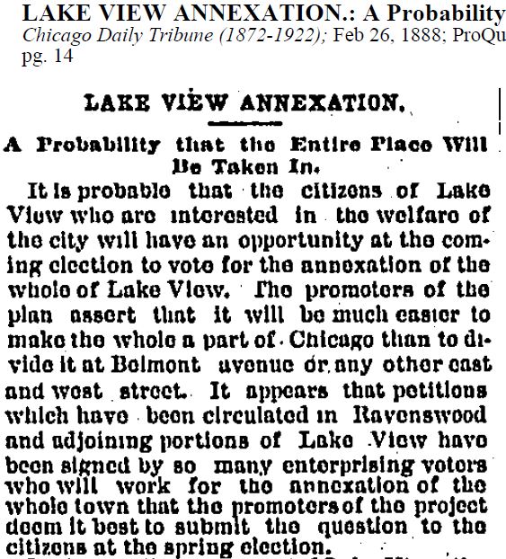
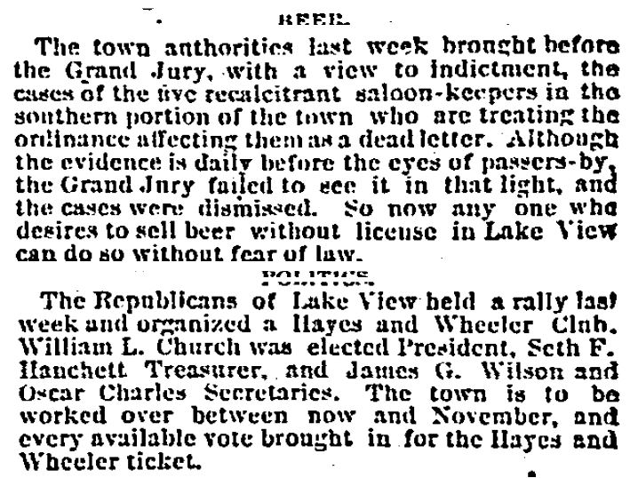
The State of Lake View (Township)
in 1876

Beer and Politics
The New Water System


The State of Lake View
in 1885
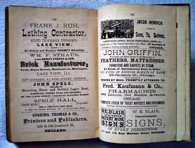
Township of Lake View


photos of the book - Ebay


The State of Lake View
in 1889
City of Lake View
the quest for annexation
and taxation
The City Govenment Experiment was Failing


The State of Lake View
in 1931
Places to Shop & Play


Commercial vs
Residencial Areas
by 1939
red=commercial & blue=residencial
dark red=manufacture

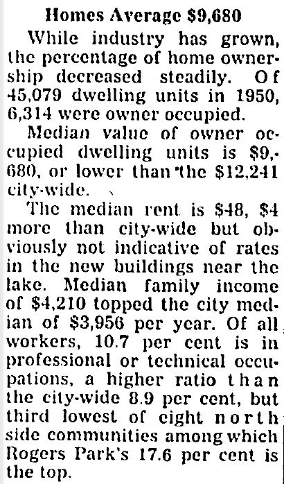
The State of Lake View
in 1957
One hundredth anniversary
old vs new Lake View


The State of Lake View
in 1963


also in 1963


The State of Lake View
in 1967

The State of Lake View
in 1969


State of Lake View
in 1971
a Neighborhood called New Town
late 1960's - early 1980's
This area covered most of Lake View East and was to market the area as something new and different like the area of
Old Town - based on diverse and trendy lifestyles.
The Neighborhood of
New Town in
1971


State of Lake View
in 1990


*to be downloaded to your computer
as a pdf file*


Lake View's
Neighborhoods/Corridors
Within

A Review ...
A neighborhood can change, and its boundaries may shift over time. Neighborhoods subdivide, emerge, revitalize, decline, and experience population shifts. Community areas are defined by the same boundaries in generally the same way over time. Amanda Seligman’s entry in the Encyclopedia of Chicago, is very helpful on this point. She writes, “Despite the uses scholars and planners have found for the concept of community areas, they do not necessarily represent how Chicagoans think about their city. So, as Seligman suggests, a neighborhood usually corresponds more closely to how we think about our city.' In other words, 'neighborhoods' may come and go within a 'community area' but community areas will remain the same in Chicago.

image - Google Maps
the light tan area is the Community of Lake View

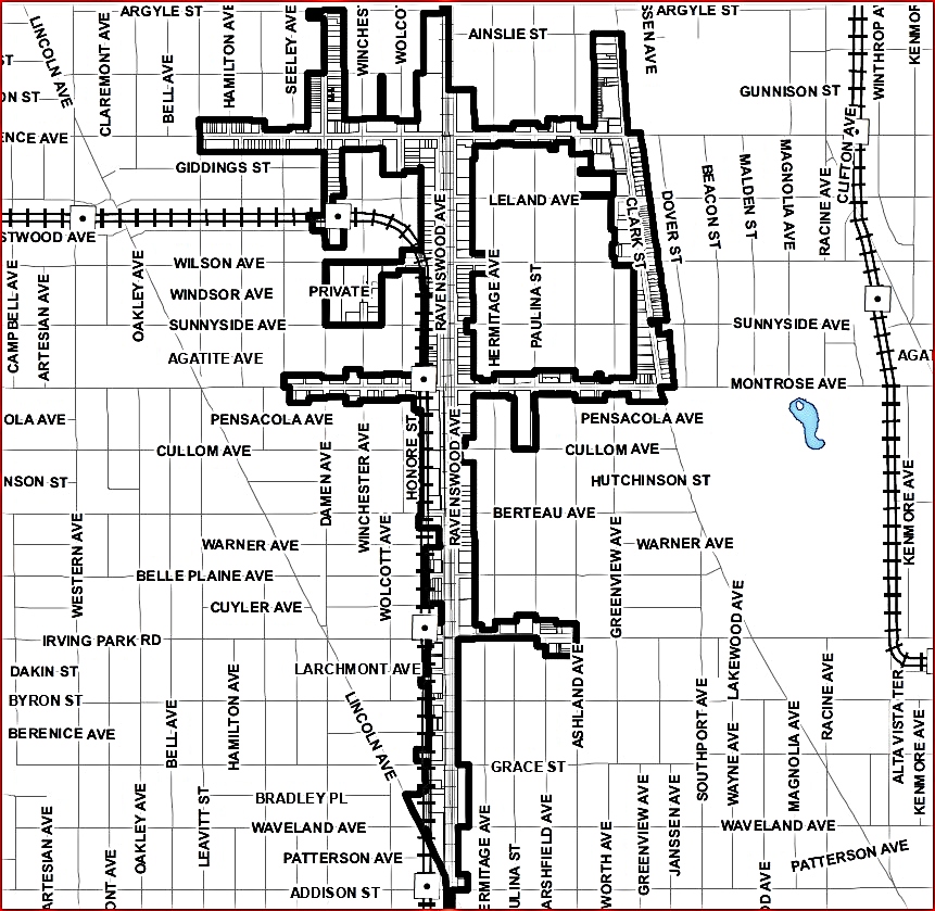
The Neighborhoods Within:
Graceland West
photos - Greeta Hootman via Pictures of Chicago-Facebook
This neighborhood has neighborhood association that is independent from the Lake View Citizens Council. This association was established by 1979.

their borders of responsibility
per their website


Greenview Avenue photo - Private Tour Chicago
 photo - Greeta Hootman via Pictures on Chicago-Facebook

These separate neighborhoods span from (East) Ravenswood Avenue to Clark Street east - Montrose to Irving Park Road. Ashland Avenue is the apparent border between this neighborhood and Graceland West. South-East Ravenswood is part of the original borders of the old Lake View Township, Community of Ravenswood. The South-East Ravenswood
Association was organized in 1983 to serve residents of Chicago's North Side in
the area from Irving Park Road to Montrose Avenue and Ashland Avenue to
Ravenswood Avenue. The original borders of old Ravenswood was Clark Street to Western and then Lawrence to Irving Park Road. After the establishment of official 'community areas' by 1930 the former Community of Ravenswood was divided between the communites of Lake View, North Central, Uptown, and Lincoln Square. As of 2016 it would seem the South-East Ravenswood community does seem to have an association but maybe just block clubs. It was a shame Ravenswood did not become a neighborhood of its own - just say'in.
a photo from yester-year
Charles Linthicum Family - Hermitage Avenue (Commercial Avenue) north of Berteau Avenue


photo map of area - Lake View Chamber of Commerce
This neighborhood of Lake View East is the home of the community areas' namesake - The Lake View Hotel (House) that was once located on the then existing lakefront on Grace Street. The hotel was constructed in 1853 as a residence during pre-township days to until the annexation of the City of Lake View by Chicago in 1889.
Elisha Hundley owned a major portion of the subdivision of Pine Grove - the original name of the area until his death by 1874. It would appear he owned property from Cornelia Street to both sides of Grace Street (hotel shown); from the original lakefront to Evanston (Broadway) Avenue.


The first building - photo 1860's?
The hotel grew in size and popularity

The hotel grew in size and popularity


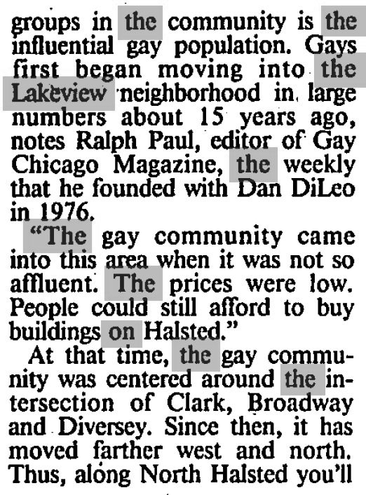
Wrigleyville & Boystown/Northhalsted area map
photo - DNAinfo
 Boystown/Northhalsted
photo - DNAinfo
Simply put, the home of Wrigley Field
and the Chicago Cubs
below photo - Southport Corridor News & Events

Northalsted (also known as Boystown) is one of the most country’s inclusive LGBTQ+ communities and the oldest officially recognized gay neighborhood in the United States. It’s known for its welcoming vibe, nonstop nightlife, LGBTQ+ owned businesses, and excellent dining options. It’s also the center of some of Chicago’s most popular events and festivals.
2023 map below
The corridor includes the properties on both (East) Ravenswood Avenue and (West) Ravenswood Avenue. The community area of Lake View ends at East Ravenswood Avenue and only on south-side on Montrose Avenue. Theis area within Lake View is 'part and parcel' the neighborhood of South-East Ravenswood mentioned above. It is a separated out due to importance and its' complexity/evolution of a manufacture and residential area. This corridor that spans a number of neighborhoods and was part of a TIF that began in 2005 and expired 2018. The TIF map below ...
The entire corridor ranges from Irving Park Road to Bryn Mawr Avenue from Bowmanville to Lake View along the vintage defaunted and forgotten Chicago & Northwestern railroad.

image via Curbed Chicago
'Up and down the Ravenswood Industrial Corridor, scrappy letterpress operators and screenprinters are carving out an analog niche in the digital world, setting type with their fingers instead of keystrokes and cranking out greeting cards and prints one piece of paper at a time by hand—kind of like swapping out an iPhone for a rotary model. Just like Printer’s Row, the corridor was hit hard by automation, innovation and consolidation, which rendered many of Ravenswood’s manufacturing plants and the products they produced obsolete. Though a handful of the corridor’s abandoned factories were converted to loft-style condos, plenty weren’t. Building owners carved up these cavernous plants into warrens of studios that happen to be the right size and the right price for printers, and it doesn’t hurt that the spaces look cool too.' - link above from Curbed Chicago.
image below via Central Square Journal
(click to enlarge)


photo above - EveryBlock
Some of the shops on Southport Avenue in 2016
from the L platform
 photo - Southport Corridor News and Events

photos below - Chicago Magazine


a citizens action organization

to Diversey on the South.


the old map above
The Belmont Harbor Neighbors - BHN dissolved in 2013. The area was mostly absorbed by East Lake View Neighbors - ELVN
2020 map


2023 map
Triangle Neighbors & Hawthorne Neighbors merged
in 2023


The LV Chambers
of Commerce:
past and present
Lake View Chamber of Commercemerged with
Roscoe Village Chamber
in 2021

former logos 


'The [former] Lakeview Chamber of Commerce is a community of entrepreneurs working together and supporting each other to create a stronger neighborhood and business environment, through advocacy, promotion, networking and education. Our organization is a leader in supporting businesses with valuable resources, programming and services that advance our neighborhood's business success, guided by our Lakeview Area Master Plan. We leverage private funding, government resources and programs, and support from more than 250 members to help our local business community thrive. The Chamber is a 501(c)6 nonprofit originally founded in 1951 as the Lincoln Belmont Ashland Business Association. The Chamber serves as the sole service provider of SSA 27, a taxing district that supports additional programs and services, including public way maintenance and enhancement.' - per their website 


3831 N Broadway

'The Lakeview East Chamber of Commerce is a broad community based organization designed to represent and help merchants and other business people in the community. It is a policy of the organization to promote goodwill and a pleasant business environment for merchants, consumers, and area residents. The Lakeview East Chamber of Commerce is the Sole Service Provider for Special Service Areas #8 and #17. Combined, the two business districts include Sheffield Avenue from Irving Park Road to Diversey Parkway; Clark Street from Byron Street to Diversey; Broadway from Grace to Diversey; Belmont Avenue from Racine Avenue to Halsted Street and Halsted from Belmont to Diversey. This area is famous for attractions like Wrigley Field, The Briar Street Theater, a thriving dining district, exciting nightlife and a number a boutique hotels and Bed and Breakfasts.'
- per their website
merged with
Central Lake View Merchants Association in late 2010's
The office was once located at
3355 N Clark Street


their new territory
the grey area in the middle belongs to the next
mentioned organization

in 1923


logo - Pride Splash Chicago
below photo - TimeOut Chicago
'Since 1980, Northalsted Business Alliance (NBA) has worked collectively to enhance the entertainment district known as Boystown. Representing over 100 In & Proud businesses, NBA is recognized by the City of Chicago, national media outlets and residents for its leadership of advancing economic vitality and quality of life for the total community. To this end, NBA provides programs and services that will increase investment, security, opportunity and activity in our district.' - per their website

of Illinois
3179 N Clark Street
Our chamber's focus is bringing together LGBTQ+
along with friendly businesses

Chamber of Commerce

the area


The Continuation of more
Photo Snippets
of Lake View


2017 photo - Tom McDonald

Chris Cullen via Original Chicago-Facebook

photo - Chris Cullen Photography

Brian Hassell via Pictures of Chicago-Facebook

Chris Cullen via Pictures of Chicago-Facebook

north corner of Halsted & Clark
photo - Raymond Kunst Fine Art Photography

2019 photo - Sandy Gordon - Whole Foods

The 'Seasons' building at Broadway & Melrose
photo - Chris Cullen Photography

view southeast from Irving Park Road & Ravenswood tracks
photo - Chris Cullen Photography

2018 photo - Joshua Mellin
via Southport Corridor News & Events

Sheridan el steps
photo - Raymond Kunst Fine Art Photography

855 W Belmont
photo - Raymond Kunst Fine Art Photography

via Judith Geisenheimer Saistone, Pictures of Chicago


a former SRO hotel
photo - Raymond Kunst Fine Art Photography

Sheridan Red Line “L”, Irving Park Road, Seminary Ave., & Dakin Street - the space under the tracks
photo - Raymond Kunst Fine Art Photography

photo - Raymond Kunst Fine Art Photography

Historical District of Alta Vista
Photography by Chris Cullen

500 block of Barry
2019 Photography by Chris Cullen
also on Barry ...


George Street and Lincoln Avenue
Chris Cullen via Pictures of Chicago-Facebook

2019 photo via Southport Corridor News and Events

2019 photo - Chris Cullen via Pictures of Chicago-Facebook

2019 photo - Wrigley Field Rooftops-Facebook

photo - Raymond Kunst Fine Art Photography

Century Mall
photo - Greeta Hootman via Pictures of Chicago-Facebook

Raymond Kunst Fine Art Photography
on a wall - Lake View Presbyterian Church Parish House

photo - Southport Corridor News and Events-Facebook

photographer Jackie Jones
via Pictures of Chicago-Facebook

photographer Jackie Jones
via Pictures of Chicago-Facebook

photographer Jackie Jones
via Pictures of Chicago-Facebook

former Wieboldt building
Chris Cullen Photography 2017

former Sexauer Garage near Whole Foods on Halsted
photo - Raymond Kunst Fine Art Photography

photo - Raymond Kunst Fine Art Photography

photo - Raymond Kunst Fine Art Photography


'Jewish Graceland'
photo - Raymond Kunst Fine Art Photography

photo - Chris Cullen Photography in Wrigleyville

2021 photo - Chris Cullen

Chris Cullen Photography
Wellington, Southport, Lincoln

on Belmont at Broadway
Chris Cullen Photography

Chris Cullen Photography
Lincoln Avenue and George Street

The Brundage Building, built 1923, was originally a bank. Lincoln Avenue between School & Roscoe along with the Lake View YMCA building on Marshfield Avenue
photo - Chris Cullen Photography via Pictures of Chicago-Facebook

 Diversey, Lincoln, Racine intersection view north
2019 photo - Chris Cullen via Picture of Chicago-Facebook


2019 photo - Chris Cullen via Picture of Chicago-Facebook

photo - Southport Corridor News & Events via @thadgs

once a home a grand mansion on Stratford Place
and my starting point for thie blog
Mike Butland via Forgotten Chicago-Facebook

2019 photo - Chicago Cubs-Facebook

2018 photo - Chris Cullen via Picture of Chicago-Facebook
3300 N Halsted Street

Chicago Harbors-Facebook
and below - Raymond Kunst Fine Art Photography

Living in Lake View
in the Day:
A Diane Wasserman-Drell Story
"I lived in the neighborhood (Patterson Avenue) from 1945-1955, and then my family moved to a house in suburbia. It was a wonderful neighborhood to grow up in at that time. Everyone knew their neighbors and everyone was friendly. There were all kinds of grocery shopping on Broadway -- everything you could imagine; a butcher shop, a fresh fish store, grocery stores, a huge Woolworths at Irving Park and Broadway. In the other direction was a couple of children's shoe stores, two drug stores on the corner of Addison and Broadway. Just to the south of Patterson on the east side of the street was Millie's dime store which was a tiny version of FW Woolworth's. At Patterson and Broadway was Borden's Dairy on the west side of the street. There was a large indoor parking garage there, and that's where my dad parked his car. The "streetcars" were on Broadway, then came the Green Hornets and then regular buses.

when she was in her 20's
It was a wonderful, much less stressful way of life. We were one of the first people on our block to get a television (10" screen), so all the kids hung out at our apartment. And..... I found a rent receipt in one of my mom's old cookbooks several years ago. It [our apt] was for $40.00 -- for a one bedroom, one bath apartment with a tiny kitchen, a large dining room, living room and a sun parlor. It also had a Murphy bed on the living room wall. We had radiators... and the coal was delivered to the basement where the washing machine (with wringers) was, and women used to hang their clothes to dry on rope with clothespins that was hung in the basement. My mother used to send a lot of her laundry out... linens, my dad's undershorts, rags and the shirts my dad wore to work. Such fond memories of a wonderful neighborhood and very decent people. I also went to Le Moyne school through 4th grade. At that time, the Chicago public schools were way ahead of the educational system in suburbia. Even though we can never turn back the clock, it's nice to reminisce about wonderful things and times in one's life. Thanks for filling in the blanks and sharing your information about the rocks and the totem pole."
Lake View Township
is Still a Thing
as a property taxing body


and as of
2021


The Status of the United States
when Lake View was Established
1857–1861: The South
Prepares to Secede
when Lake View was Established
1857–1861: The South
Prepares to Secede

General map of the United States, showing the area and extent of the free & slave-holding states, and the territories of the Union: also the boundary of the seceding states - Library of Congress

The 1850’s were violent and tension-filled years in the United States, as arguments about slavery and states' rights exploded all over the country. Despite all the efforts of many lawmakers, the hostility between the North and the South seemed to increase with each passing month. A number of events in the early and mid-1850s contributed to this deterioration in relations between the two sides, from the publication of Harriet Beecher Stowe's Uncle Tom's Cabin to the bloody battle for control of Kansas. But the blows that finally broke the Union in two took place in the final years of that decade, as the North and the South finally saw that their vastly different views of slavery would never be resolved to everyone's satisfaction. "There were serious differences between the sections," wrote Bruce Catton in The Civil War, "[but] all of them except slavery could have been settled through the democratic process. Slavery poisoned the whole situation. It was the issue that could not be compromised, the issue that made men so angry they did not want to compromise." One of the most important legal decisions in American history took place in 1857, when the U.S. Supreme Court had to decide whether a slave named Dred Scott (c. 1795–1858) should be granted his freedom. The Court's ruling against Scott further increased the hostility and distrust between America's Northern and Southern regions, in part because it suggested that slavery could be legally instituted anywhere in the country.
My Last Word, .... for now
Lake View is one of the 77 'community areas' in the City of Chicago. Explore the other community areas with this link.
I have posted nearly 70 entries to this blog.
You can contact me at lvhistorical@gmail.com
Feel free to comment/question on anything in particular including spelling and grammar errors. I add text and images all the time. I am sure there is more knowledgeable individuals then me and better writers who can enrich this site even more.
I welcome your insight!
Follow me to my next post called
Important Note:
These posts are exclusively used for educational purposes. I do not wish to gain monetary profit from this blog nor should anyone else without permission from the original source - thanks!