The Lost Connection of the
Boulevard/Park System
Boulevard/Park System
The related post to this one is called
but first, the failed boulevard connection to the park
zoomed views below:


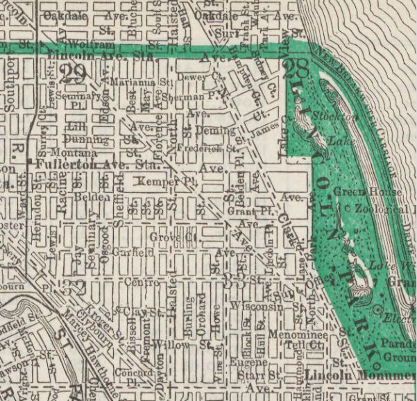
1908 map by Library of Congress
This map highlights the expansion of the park northward and the proposed boulevard link to Lincoln Park via Diversey


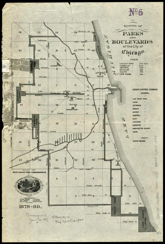
THE BOULEVARD SYSTEM OF CHICAGO

When Chicago officially
incorporated as a city in 1837, it adopted the motto “Urbs in Horto,” a Latin
phrase meaning “City in a Garden.” Despite this verdant slogan, the city had
few public parks. Early residents succeeded in saving two small parcels of the
lakefront as parkland. The few other small parks created during the 1840’s and
1850’s were donated or sold to the city at reduced rates by real-estate
developers. These speculators knew that a small square in the center of a
residential development would boost the value of the entire subdivision. In
1849, real-estate speculator John S. Wright suggested a much more ambitious
system of parks and interconnected pleasure drives. At the time, however, the
city government had neither the administrative nor the legal means to realize
this vision. In the late 1860's Chicagoans rallied for additional parks, prompting the State Legislature to
establish the South, West, and Lincoln Park Commissions in 1869. Each
commission served its own jurisdiction and was responsible for improving one section
of what was intended as a unified park and boulevard system. Reflecting
Wright's suggestion of 20 years earlier, a ribbon of parks and pleasure drives
encircling the city was envisioned.

It is certain, at least,
that the foundations of Lincoln Park were laid in 1837, with the grant to the
town[ship] of North Chicago of state lands for cemetery purposes, and in 1852, when
under pressure of the cholera panic the city bought the land north of Fullerton
Avenue for quarantine and hospital grounds [that was once part of the Township of Ridgeway (1850 - 57) and then the Township of Lake View in 1857].
 Diversey Avenue Bridge in 1900
"The Chicago boulevard system is completed when the
Diversey Parkway bridge over the North Branch of the Chicago River is
opened. Chicagoans can now have a
complete set of scenic roads over which they can travel “over Diversey and
Humboldt boulevards to Humboldt Park, Central Park boulevard to Garfield Park,
Southwestern boulevard to Douglas Park, thence over Western Avenue boulevard to
Garfield boulevard and Jackson Park, and north in Michigan avenue to Lincoln
Park, completing the circuit.” [Chicago
Daily Tribune, 1900]. - Connecting the Windy City. While this statement was sorta true, the boulevard connection to Lincoln Park was hindered by property rights issues and conflicting governance issues between the the Lincoln Park Board Commissioners and the City of Chicago & taxes from the get go.
The West Chicago Park Commissioners
confer with the City of Lake View in 1881
The taxing authority for Humboldt Park was the West Chicago Commissioners and Lincoln Park was the Lincoln Park Board
of Commissioners while the streets were governed by the City of Lake View and the City of Chicago west of the North Branch of the Chicago River; yes it got complicated.


text - 'Lincoln Park 1899'
Because the cost of the Boulevard System laid squarely on the property owners of the roadway and not the taxing authorities of the townships the business owners declined to pay for it ...


Articles about the Boulevard Linkage:
I hope you like reading
Petition for Governance in 1881

*City of Lake View becomes District of Lake View within the City of Chicago in 1889*
A Boulevard Connection
on Wellington in February 1891

in 1891

 Diversey not Wellington to be Governed
by Lincoln Park Board of Commissioners
in July 1891


 Planting Trees
Lincoln Park Board of Commissioners
Divided on Diversey Issue in 1897
in 1899


Paving the Streets
in 1899
Let There be Light!
Says the Judge in 1900

A Perspective on
Diversey Boulevard in 1900


The Chain of Boulevards
in 1904


Widening the old Boulevard
Still an Issue in 1928


40% Want a Widen Diversey
in 1931

The Contents of the Lincoln Park System
by 1904
*Lincoln park boulevard=Michigan Avenue*

according to WTTW's Geoffrey


and below
a current map
of the boulevard/park system in Chicago

with a zoomed view of our area below
guess what's missing??

Post Note:
What's a Parkway?
Ours is just a route to a park, Lincoln Park

via Google Maps
from inner Lake Shore Drive west

These posts are exclusively used for educational purposes. I do not wish to gain monetary profit from this blog nor should anyone else without permission for the original source - thanks!