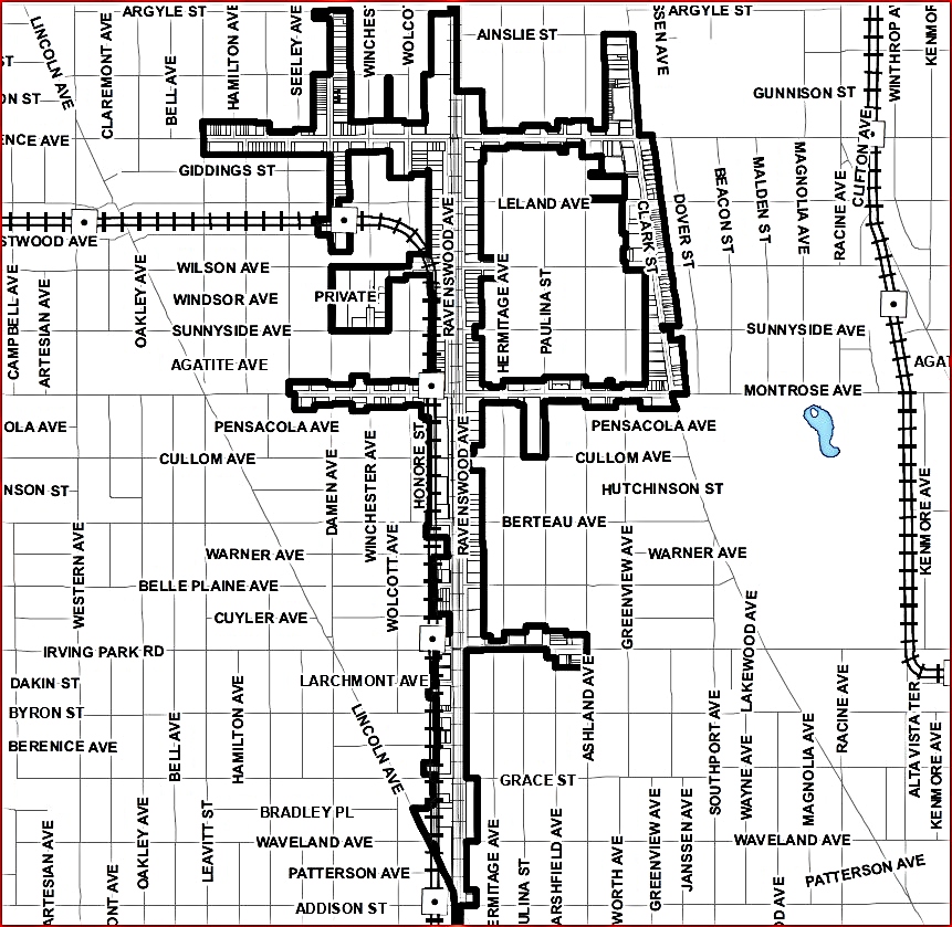
'The Lakeview East Chamber of Commerce is a broad community based organization designed to represent and help merchants and other business people in the community. It is a policy of the organization to promote goodwill and a pleasant business environment for merchants, consumers, and area residents. The Lakeview East Chamber of Commerce is the Sole Service Provider for Special Service Areas #8 and #17. Combined, the two business districts include Sheffield Avenue from Irving Park Road to Diversey Parkway; Clark Street from Byron Street to Diversey; Broadway from Grace to Diversey; Belmont Avenue from Racine Avenue to Halsted Street and Halsted from Belmont to Diversey. This area is famous for attractions like Wrigley Field, The Briar Street Theater, a thriving dining district, exciting nightlife and a number a boutique hotels and Bed and Breakfasts.'
- per their website
merged with
Central Lake View Merchants Association in late 2010's
The office was once located at
3355 N Clark Street
their new territory
the grey area in the middle belongs to the next
mentioned organization
in 1923
logo - Pride Splash Chicago
below photo - TimeOut Chicago
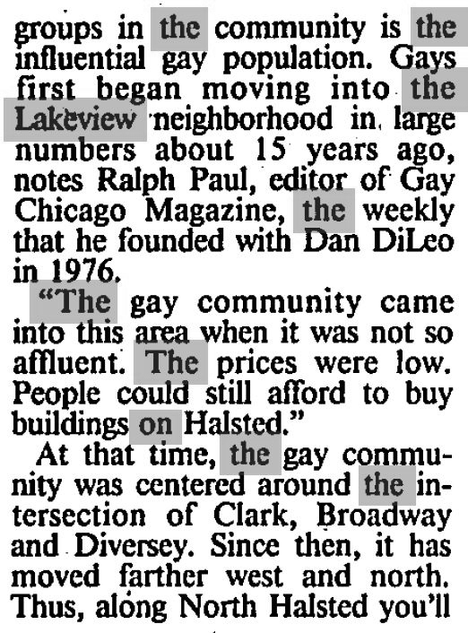
'Since 1980, Northalsted Business Alliance (NBA) has worked collectively to enhance the entertainment district known as Boystown. Representing over 100 In & Proud businesses, NBA is recognized by the City of Chicago, national media outlets and residents for its leadership of advancing economic vitality and quality of life for the total community. To this end, NBA provides programs and services that will increase investment, security, opportunity and activity in our district.' - per their website
of Illinois
3179 N Clark Street
Our chamber's focus is bringing together LGBTQ+
along with friendly businesses
Chamber of Commerce
the area
The Continuation of more
of Lake View
2021 photos - Oleg Tiunicov via Original Chicago/Facebook 2017 photo - Tom McDonald
Chris Cullen via Original Chicago-Facebook
photo - Chris Cullen Photography
Brian Hassell via Pictures of Chicago-Facebook
Chris Cullen via Pictures of Chicago-Facebook
north corner of Halsted & Clark
photo - Raymond Kunst Fine Art Photography
2019 photo - Sandy Gordon - Whole Foods
The 'Seasons' building at Broadway & Melrose
photo - Chris Cullen Photography
view southeast from Irving Park Road & Ravenswood tracks
photo - Chris Cullen Photography
2018 photo - Joshua Mellin
via Southport Corridor News & Events
Sheridan el steps
photo - Raymond Kunst Fine Art Photography
855 W Belmont
photo - Raymond Kunst Fine Art Photography
via Judith Geisenheimer Saistone, Pictures of Chicago
2021 photo - Amit Jhingran
a former SRO hotel
photo - Raymond Kunst Fine Art Photography
Sheridan Red Line “L”, Irving Park Road, Seminary Ave., & Dakin Street - the space under the tracks
photo - Raymond Kunst Fine Art Photography
photo - Raymond Kunst Fine Art Photography
Historical District of Alta Vista
Photography by Chris Cullen
500 block of Barry
2019 Photography by Chris Cullen
also on Barry ...
George Street and Lincoln Avenue
Chris Cullen via Pictures of Chicago-Facebook
2019 photo via Southport Corridor News and Events
2019 photo - Chris Cullen via Pictures of Chicago-Facebook
2019 photo - Wrigley Field Rooftops-Facebook
photo - Raymond Kunst Fine Art Photography
Century Mall
photo - Greeta Hootman via Pictures of Chicago-Facebook
Raymond Kunst Fine Art Photography
on a wall - Lake View Presbyterian Church Parish House
photo - Southport Corridor News and Events-Facebook
photographer Jackie Jones
via Pictures of Chicago-Facebook
photographer Jackie Jones
via Pictures of Chicago-Facebook
photographer Jackie Jones
via Pictures of Chicago-Facebook
former Wieboldt building
Chris Cullen Photography 2017
former Sexauer Garage near Whole Foods on Halsted
photo - Raymond Kunst Fine Art Photography
photo - Raymond Kunst Fine Art Photography
photo - Raymond Kunst Fine Art Photography
J.R. Schmidt Photography'Jewish Graceland'
photo - Raymond Kunst Fine Art Photography
photo - Chris Cullen Photography in Wrigleyville
2021 photo - Chris Cullen
Chris Cullen Photography
Wellington, Southport, Lincoln
on Belmont at Broadway
Chris Cullen Photography
Chris Cullen Photography
Lincoln Avenue and George Street
The Brundage Building, built 1923, was originally a bank. Lincoln Avenue between School & Roscoe along with the Lake View YMCA building on Marshfield Avenue
photo - Chris Cullen Photography via Pictures of Chicago-FacebookDiversey, Lincoln, Racine intersection view north2019 photo - Chris Cullen via Picture of Chicago-Facebook
photo - Southport Corridor News & Events via @thadgs
once a home a grand mansion on Stratford Place
and my starting point for thie blog
Mike Butland via Forgotten Chicago-Facebook
2019 photo - Chicago Cubs-Facebook
2018 photo - Chris Cullen via Picture of Chicago-Facebook
3300 N Halsted Street
Chicago Harbors-Facebook
and below - Raymond Kunst Fine Art Photography
Living in Lake View
in the Day:
A Diane Wasserman-Drell Story
"I lived in the neighborhood (Patterson Avenue) from 1945-1955, and then my family moved to a house in suburbia. It was a wonderful neighborhood to grow up in at that time. Everyone knew their neighbors and everyone was friendly. There were all kinds of grocery shopping on Broadway -- everything you could imagine; a butcher shop, a fresh fish store, grocery stores, a huge Woolworths at Irving Park and Broadway. In the other direction was a couple of children's shoe stores, two drug stores on the corner of Addison and Broadway. Just to the south of Patterson on the east side of the street was Millie's dime store which was a tiny version of FW Woolworth's. At Patterson and Broadway was Borden's Dairy on the west side of the street. There was a large indoor parking garage there, and that's where my dad parked his car. The "streetcars" were on Broadway, then came the Green Hornets and then regular buses.
when she was in her 20's
It was a wonderful, much less stressful way of life. We were one of the first people on our block to get a television (10" screen), so all the kids hung out at our apartment. And..... I found a rent receipt in one of my mom's old cookbooks several years ago. It [our apt] was for $40.00 -- for a one bedroom, one bath apartment with a tiny kitchen, a large dining room, living room and a sun parlor. It also had a Murphy bed on the living room wall. We had radiators... and the coal was delivered to the basement where the washing machine (with wringers) was, and women used to hang their clothes to dry on rope with clothespins that was hung in the basement. My mother used to send a lot of her laundry out... linens, my dad's undershorts, rags and the shirts my dad wore to work. Such fond memories of a wonderful neighborhood and very decent people. I also went to Le Moyne school through 4th grade. At that time, the Chicago public schools were way ahead of the educational system in suburbia. Even though we can never turn back the clock, it's nice to reminisce about wonderful things and times in one's life. Thanks for filling in the blanks and sharing your information about the rocks and the totem pole."
Lake View Township
is Still a Thing
as a property taxing body
and as of
2021
2025
Lake View Stats
in 2025
Vintage Lake View
most were donated to Sulzer Regional Library and Lake View High School Alumni in 2025
Volume 1
505 Stratford Place
505 Stratford Place began my quest
for Lake View's historical past 

10 by 14 inches in size page
The residence of Edith (Lehmann) Behr once graced the corner of Stratford Place & inner Lake Shore Drive, now a parking lot for the Temple Sholom. The curiostiy of the the parking lot encourage me to write a blog about the history of my block and Lake View from its inception.
Lake View Township
Governmental Reciepts
reverse side
The Tax Reciepts
of K. Langlard
reverse side
reverse side
k. Langland owned property in "Wrightwood" that was originally called Wright Woods, then Wrightwood Grove. The Community of Lincoln Park lays claim to this area south of Diversey Parkway to probably Fullerton Avenue.
reverse side
reverse side
reverse side
a notification from the County's Assessor's Office in 1895 of property in an assessed area called Lake View Township
pre 1909 address above
post 1909 address below
2710 N Lincoln Avenue
and reverse side of postcardThe Pathways In &
Out of Lake View entering from the south from Lincoln Park, the park Fullerton Avenue was once the border between the City of Chicago and the City of Lake View
 prior to 1889

and then without pedestrians
Entering from the south along the broadwalk at Diversay along the Outer Drive
 passing Elk Memorial heading northward to Diversey Parkway from either Cannorn Drive
 or Lake View Avenue


 Before there was the Elk Memorial the property was the residence of Mrs J.L. Lehmann
 traveling north along the then existing lakeshore in Lake View
 passing the Pattington Apartments at Pine Grove
 & Irving Park Road
 exiting Lake View on the Outer Drive and
 Irving Park Road

Fullerton Avenue was once the border between the City of Lake View and the City of Chicago prior to 1889. Lake View Avenue once stretched from Fullerton Avenue to Belmont Avenue before the existence of Sheridan Road in the lat 1890s.
zoomed from above
View of Lake Michigan
from Lake View
zoomed from above
(City of Lake View??)
Belmont Yacht
Harbor
 the first boathouse
 - operational 

an album view
selected pages
the home of Depression Era marathon dances
tri-fold phamplet below
Vintage
Landscapes
the broadway along Lake View the broadway along what was then Sheridan Road ranged from Diversey Parkway to just north of Grace Streetsome of the messages are interesing to read
zoomed text from above
t
he Stout Estate border Sheridan Road and inner Lake Shore Drive between Briar Place & Barry Avenueviewing north just north of Brompton Place on Sheridan Road (inner LSD)zoomed text belowSheridan Road & Irving Park Road
The Lake View Telephone Exchange building (pre AT&T)
an interior viewbefore the high-rises text view below
Albert Fuchs owned property and buildings north of Grace Street along Halsted Street
view of Lake View East from Diversey Harbor - St Joseph Hospital, white colored building Houses of Worship
Landscapes
&
The Township of Lake View Library:
First Up....
St. Alphonsus Parish
the second church buildingthe first Temple Sholom building currently Anshe Emet SynagogueRavenswood Methodist Evangelical ChurchAcademy of the Sacred Heart on Pine Grove AvenueLake View
Congregational Church
silk 1890's book markers
zoomed viewscalendar of church sermonsRavenswood
Presbyterian Church
11 by 14 inch page
the Lake View Township Library once located on Montrose & HermitageLake View's School
Landscapes
Class of 1913
Lake View School [Township] #2
zoomed from above photoback of photoNettelhorst School
once known as Lake View Township #1
The original brick & mortor school behind the newer by street
a 1959 newsletter
selected pages
the graduates for that year
back page
Ravenwood School
Lake View
High School
the newer & current building and the second constructed building to the rightthe other addition to the schoolClass of 1913zoomed view belowa more closer view
the older building on the right replacedan anniversey postcard
Lake View's
Theatres:
Chateau Theatre
Roscoe Theatre
Booklet
the back cover
The Victoria (Vic)
Theatre
selected pages

zoomed text belowzoomed below
the back cover
Julian Theater
Lake Shore Theatrebi-foldBuckingham TheatreMusic Boxwith an aniversery metal pinzoomed text belowLake View's Hotel
Landscapes:
The Rienza Cafe
once located on the northeast corner of Broadway &
Diversey Parkway
Winter View
Spring View
from a cafe to a hotel just east of the original cafe location Hotel Belmont
currently called Reside on Belmont
8 by 10 full page article


This hotel was constructed in 1924
zoomed text below
.jpg) the hotel with the Sheridan Monument in the forefront
the hotel with the Sheridan Monument in the forefrontBelmont Apartments
Brewster
Apartments
The Belair [Apartment] Hotelzoomed text belowPalais Brompton Hotel
currently called Majestic Hotelzoomed text belowThe Surf Hotel
&
Park Lane Hotel
both apartment hotels
reversed inside flapszoomed text belowzoomed text belowzoomed text belowThe Cambridge
Apartment Hotel
currently called the
530 Diversey Apartments
zoomed text belowThe Lessing & Lessing Annex Apartments
both located north and south of Surf Street
currently called the Commordore and Green Brier Apartments
Diversey Arms [Apartment] Hotel's Lounge
The hotel is currently called
The Versey Hotel Days Inn
reversed
Lake View's Hospital
Landscape:
Lincoln Park Sanitarium
for Sick Babies
Constructed just north of Diversey Parkway on a inlet along the lakefront in 1886 when Lake View was a township and later to be renamed Chicago Daily News Sanitariumzoomed text belowMarine Hospital of Chicago
Township of Lake View
District of Lake View
Community of Uptown
Initially called the Federal Hospital for Sailors & Soldiers was constructed between 1869-72 when Lake View was a township. Currently the area location of Walt Disney Magnet School in the Community of Uptown A Report Card Letter for Repairs
to the Congress in 1901
zoomed view belowOther Lake View
Past & Present Hospitals:
St. Joseph Hospital
currently called the
Acension St. Joseph Hospital
the precusor to
Illinois Masonic Medical Center
currently called
Advocate Illinois Masonic Hospitalzoomed text belowIllinois Masonic
School of Nursing
the building is currently used as apartments
on Diversey Blvd (Parkway)
zoomed view belowLake View Hospital District of Lake View
renamed Frank Cuneo Hospital
District of Lake View
zoomed view below
The home of St Frances Xavier CabriniLake View's
Social Support Organizations
Landscape:
established in 1869

Their church on Wilton Avenuea photographa cadet from the Wilton location
Baptist Missionary
Training School
 the reverse side of all these postcards
 Lake View's
Transportation Landscape:
The Belmont L Station
published in 1982also published in 1982The Trip to Milwaukee
from the Belmont L Station
As late as 1963, it was possible to board high-speed electric trains on Chicago's famous Loop "L" that ran 90 miles north to Milwaukee. This was the
zoomed views belowtimetable zoomed from full page
typical pages belowback coverNorth Shore
ticket subs
a complete ticket below
a conductors round trip ticket

Chicago Area Maps:
The Native American Trails
according to this 1804 (reprint) map
a zoomed view of our area below
The Highway System
of 1852
(reprint) map
Before there was the Township of Lake View (1857-1887) there was Ridgeville Township (1850-1857). I superimposed labels and a border to this map. Ridgeville was composed on the areas of Lake View and southern Evanston. The population of Ridgeville was 443 according to this map. zoomed further below
Chicago Rapid Transit
Maps:
The CRT was the precusor to the CTA
These maps focus on the expansion
of Lincoln Park, the park
Rand McNally
Pocket 1910 Map
this map shows the proposed Lincoln Park extension
to Devon Avenue in green
zoomed view of our area belowRand McNally
Chicago Guide
published in 1927Rand McNally
Street Guide of Chicago
published in 1942
Sight Seeing
via Chicago Surface Lines
this map was published in 1921the folded out map belowa zoomed view below Lincoln Park extended only to Cornelia Avenue
at this time
Rand McNally
Map
unknown date on the map but probably the late 1920's early 1930's
Lincoln Park extended to Irving Park Road at this time
The Rapid Transit Lines
1935 Map
highlighting Lincoln Park northward limits at the time
below is the backside of this phamplet
The Rapid Transit Lines
1942 Map
zoomed view below Lincoln Park extends to just north of Foster AvenueChicago
Motor Coach Map
from the early 1950's?
zoomed below on our area's routes
Chicago Rapid Transit Line
Tickets
.jpg) The Northwestern, Metropolitan and South Side companies consolidate in 1924
The Northwestern, Metropolitan and South Side companies consolidate in 1924 under the Samuel Insull control
1935 ticket
1 by 1 inch in size
1932-1947
Chiago Surface Lines
Chicago Transit Authority
zoomed from one of the paper transfers The Status
of Sheridan Road
published in 1916
8 by 10 magazine
total of 2 pages on subjectwith zoomed view of one sectionback cover An Auto Repair
Shop
at Lincoln/Ashland avenues
zoomed below
zoomed view belowBuilding Shingles vs
The Elevated
materials donated by Arelene Nybakken Chase
This a photo story a church building that got in the way of the construction of the Northwestern Elevated (Howard/Redline) tracks. The 1906 letter below was issued by the company to a
Nels Anderson to remove some items from the church building before construction of the tracks. His other building in the back (view map) was not effected.
zoomed below
the items to be removed below
the 1887 deed to the building/church below
when Lake View was a township in Cook County
zoomed below
another deed in 1889
zoomed view
Color Slides:
The #8 Halsted heading south on Halsted Street just south of Waveland Avenue
and below
Belmont L Stationon the Ravenswood tracks
Diversey L Station on the Ravenswood tracks
The Halsted #8? heading south from Clark Street toward Halsted StreetFull Page Advertisements
11 pages worth
1945
1946
January 21
1946
March 4
1946
September 16
features Halsted-Clark trolly
1946
July 30
features Montrose Avenue
1946
July 8
1947
April 24
Lake View
Township Cemeteries:
RoseHill Cemetery
reverseGraceland
Cemetery
back side1901 owners handbook
back coverGraceland Cemetery Property Deed
issued in 1887
when Lake View was a city in Cook County
Street-End
Bathing Beaches
Before Sheridan Road, North Lake Shore Drive. and the park beyond North Avenue there was a beach at the end of countless streets that ended at the lakefront during the 19th century to the early 20th
Fullertona Avenue Bathing Beach (Children & Women only)Diversey Avenue BeachBelmont Harbor Beach
and
Local Harbors:
and the narrow beach.jpg)
the entrance to the harborChicago History
in Postcards
an artist view
the artist

 Early Chicago
in Postcards
The Mouth of the
Chicago River
Fort Dearborn
Century of Progress Exibit
Illinois in Postcards
his apparent Kentucky home his apparent Illinois home Illinois State Capitals: (maps not included)
Kaskaskia
as the Illinois Territorial capital
1809-1818
and then the Illinois state capital
1818-1820
1820-1837
highlights the then existing counties
The most northern area still belonged
to the Native Americans
Springfield
1837-present
Volume 2
and Lake View ...
The Photographic Studios:
W.C. Lorteman [Studio]
738 Belmont Avenue
with a post 1909 address
1622 W Belmont Avenue
.jpg) reverse side
reverse side
zoomed below
A.H. Genizel [Studio]
659 Lincoln Avenue
City of Lake View
(1887-1889)
post 1909 address of
2740 N Lincoln Avenue
Belmont Studios
960 Belmont
post 1909 address
Lake View
Personalities:
Mayor of the
City of Lake View
a 1900 campaign button
he tried and failed to run for mayor of Chicago
Mayor 'Big Bill'
William Hale Thompson
Mayor of Chicago
1915-1923 & 1927-1931
A Resident of Lake View East
a campaign song sheet
back cover
anti - Britishhe tried to ban so-called 'british published' books for schools
thought himself a cowboy at heart

zoomed from above
a 1929-31 tally sheet
press photos below
 zoomed from above
 zoomed from above
He tried and lost a campaign for Illinois governor while between jobs as a mayor
He loved campaign stunts
zoomed from abovea circus in the chambers of City Hall
zoomed from abovezoomed from above
William Hearst,
zoomed from abovecampaign rally in 1931
zoomed from aboveanti-war supporter in 1938
zoomed from aboveGloria Swanson
a young resident of the
District of Lake View
of Sunset Boulavarda 1923 magazine
zoomed from aboveback cover
a 1945 playbill
back coverFire
PostcardsVolume 3
A 1922 view
of the Nascent Harbor
opened to the public in 1913
zoomed from above
The first clubhouse (1921-1923) was called the Carrier, a rig that was reconfigured toa schooner. The Carrier was built in 1865 apparently used to traffic cut timber in the Lake Michigan region. View the 1930ish Belmont Yacht Harbor boat application view below for details.
and zoomed from above showing the Carrier
a 1920's view
zoomed from above
zoomed further from above
and traffic heading north & south below
printed from a negative I purshased from Ebay
Another 1920's view
zoomed from above
zoomed further from above
double deckers below
A Vintage Aerial
View
a 1930's? view
zoomed from above
it appears that the pedestrian bridge was removed
at this time
The Second Clubhouse
This clubhouse had a fabric canopy
Artic Explorer
in Harbor
The Storm
of 1929
Photography by Berry
Ships in the Harbor
unknown date
the ship shown could be the first clubhouse, Carrier
zoomed from aboveBefore the Belmont
Overpass Bridge
before the construction of the Belmont Overpass Bridge that was constructed by 1942, the final piece to the WPA's Lake Shore redevelopment
Boat
on Fire
An Aerial View
in 1940
zoomed from above
zoomed from above
A Personal Photo
I believe this photo was taken of Belmont Harbor
The Widening
of Lake Shore Drive Photos
(construction of the Belmont Overpass Bridge
by 1942)
probably taken from the Park Lane Apartment Hotel
these photos are from negativesAn Application to Chicago Motor Yacht Club at Belmont Harbor
zoomed from above
.jpg)
the 'Club Ship' was called The Carrier
.jpg)
zoomed from above
Home of a
Nike Missile Site
Boats
at Rest

zoomed from aboveAerial View
in 1959

zoomed from aboveA Foggy
Day
A Stormy
Day
Smelt
Fishing
Russians in the
Harbor
Automobile
Sank in Harbor
Dead
Elewifes Piling Up
Another
Foggy Day
Safety
First

zoomed from aboveBiking
in 1965
Taking the Schooner
Out for the Day
zoomed from above
Missiles
in the Harbor
Aerial View
in 1970 with of view
Coast Guard
to the Rescue
jumbo photoWhat Remains
of the Nike Missile Site
Ocuppied
Belmont Harbor
The Belmont Rocks
in 1973
jumbo photoA Race
at Belmont Harbor
jumbo photo
Oil Slick
in the Harbor
Another Race
Event
Pay
as You Go
The Mayor and Salmon
Dumping
Alone
and Fishing
View Looking
Northeast
jumbo photoAn Annual Race
at Belmont Harbor
Sails
and the Winter Ice
Boat
on Fire
Smelt Fishing
in 1985
An Xmas
Visit
Boating Season
Begins Again
Doggie
Beach
Walking
the Pet
Chicago Tabernacle Gospel
Church
referred to as the Radio Church
By the early 1920's the radio, still a relatively new means to communicate wirelessly, grew in popularity. The sermons used the radio to spread their message to the nation and the world from a location in Lake View.
the leader of this congregation
selected pages
1879-1938
zoomed from above

zoomed from above

zoomed from above

zoomed from above
back cover
a 1930 song booklet
selected pages

zoomed from above

zoomed from above
back cover
1943 press photos
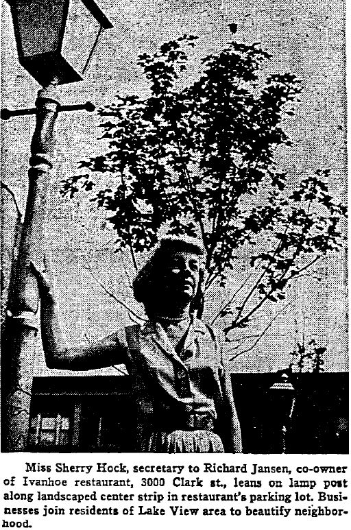
Ivanhoe Restaurant & Playhouse (theater + dinner)
Once known for its' live theatre performances from nationally known personalities after enjoying a dinner, hence blending a dinner with theatre.
a cardboard cover
to a possible menu
and below
a paper drink mat
a menu

zoomed from above
draw and color while you wait???
back coverzoomed below
a mailer
zoomed from above1964 press photo a 1967 playbill
zoomed below
zoomed from above
back cover
zoomed from above
back covera 1969 press photoa 1973 press photoa mailer
zoomed from above
Menu's & Dishes
a menu booklet

zoomed from above
zoomed from above
zoomed from abovc
back cover
a mailer

zoomed from abovean insertopens from the middle


zoomed from above
back cover

zoomed from aboveSmall Plate
& Creamer
Plastic Mixing Sticks
Small Decorative Plate
1975 photo
1976 press photo
The Hotel Belmont
& their hotel restaurants
currently called
 stationary
matchbook
a 1943 menu
zoomed from aboveback covermatchbooks
a later date menu zoomed from above
.jpg)
.jpg) back cover
back coverMetal
Bread Trays
zoomed from above
with the hotels' tradmark below
a relish folk??
reverse side
zoomed from aboveVolume 4
View of Sheridan Road
at Belmont Yacht Harbor 1925
A page from an apparent magazine that advertised a product that features Sheridan Road at Belmont Harbor in 1925. Belmont Yacht Harbor opened to the public in 1916. The images below are zoomed for this page.
the view is north to northeastUnion Hospital
a precusor to Advocate Illinois Masonic Hospital
1901-1921
zoomed from above
the automobiles are parked on Wellington Avenue steps away from Halsted Street
Lake View
Post Office
a 1930ish photo
zoomed from above
backsidezoomed from above
North Lake Shore Drive and
Sheridan Road
at Melrose Street 1932
zoomed from above
Lake Shore Drive (not Belmont Avenue) to the right and Sheridan Road to the left and Melrose Street to the left of the inserted photo - view north from the General Sheridan Monument
Ashland, Belmont, Lincoln
Intersection 1922
Elevated Curbs
on Lake Shore Drive
in 1940
Ice Skating at Waveland Park
in 1947
Three Personal Photos1940's?
Looking east from Fletcher and Clark through vacant lots towards Halsted Street showing the Curtiss Candy factory - Baby Ruth sign. To the right is the future Briar Street Theater
No Heat on the Elevated
in 1950
Chicago Mayor at Wrigley Field
in 1951
The Diversey Chicago Motor Couch
unknown date
Street Signage on Lake Shore Drive
in 1954
view is at Melrose Street on Lake Shore Drive
looking north installing a new sign
Lake View High School Dress Rehearsal
in 1955
This was a donation from Carol Brennan. She was a student of Lake View High School during the early 1950s. She not only donate this photogragh but all her yearbooks to me.Fire at Waveland & Halsted
in 1956
Nettelhorst Elementary Students
at Science Fair
in 1956
Ice Skating Practice at Waveland Park in 1957

zoomed from aboveNorth View on Inner Lake Shore Drive
in 1957

zoomed from aboveNettelhorst Elementary Health Fair
in 1958
Lake View High School Band
in 1958
Vistitor at the Old Town Hall
in 1958
Portable Heater at
Old Commerical District
in 1958

zoomed from aboveWindow Shopping at the
Old Commerical District
in 1960

zoomed from aboveProtesting Against War
in 1961

zoomed from abovefrom purchased negatives
View of Temple Sholom
in 1961
The Mourning of Kennedy
at Temple Sholom
in 1963

zoomed from aboveWOOGM'S Parade
on Oakdale Avenue
unknown date
James Addams Center
on Broadway 1963
Drama at the Wellington Hand Laundry in 1967
The 'Slave Desk' at
Illinois Masonic Hospital
in 1967
Singer Wins Aldermanic Race
in 1969
alderman of the 44th ward 1969-71
and the 43th 1971-75
Lincoln Park Gun Club Range
in 1969
Native American Protest in Wrigleyville in 1970
Alderman Simpson at Hearing
unknown date
alderman of 44th ward 1971-79
Alderman Singer at the Democratic Convention in Chicago
1972
A Protest Performance on
Wellington Avenue in 1971

zoomed beloweastern Lake View was once called New Town during the 1970's as part of a re-make very diverse areaFlooding along the Lakefront
in 1972
Wrigley Field Ticket Booth
in 1972
Police Investigation
on Patterson Avenue in 1972
A Sidewalk Hazard on Oakdale
in 1973
Flooding of Golf Course
in 1973
Summer Fun along the Waveland Avenue Rocks in 1974
Overcrowd Platform
in 1975
Snow & Tennis
in April 1975
Waveland Avenue Golf Course
in 1975
AKA
'Tokyo Rose' at Family Business
in 1976
the family business was once located on 851 W Belmont Avenue - worked there with her familyOut of the Park at Wrigley Field
in 1980
Packed Crowd at Wrigley Field
in 1977
Protest of a Strike at Wrigley Field
in 1985

zoomed from aboveLine-up of Abandon Cars
in 1980
.jpg)
A Snowy Commute on LSD
in 1981
the location is more near Grace Street then Belmont but the view is still south of LSDA Storefront Composite on Broadway
in 1981
Playing in the Puddle
in 1981
A Cold Day for Baseball
in 1981
The Old Commerical District
in 1982
Fitness along Lake Shore Drive
in 1982
Tons of Pumkins
in 1982
A Pet Parade
in the Old Commerical District
in 1982
Broadway & Belmont
in 1983
Southport Lanes
in 1984
The Governor at Murphy's Bleachers
in 1984
Fires on Halsted Street
in 1984
Another Pet Parade
in 1984
Running along the Rocks
in 1985

The Return of Kwa Ma Relas
in 1985

zoomed from above
.jpg)
Golf and Fog
in 1988
Maintenance on Sheffield Avenue
in 1990
Hockey at Waveland Park
in 1991
The Re-Sufface of Lincoln Park Gun Club in 1993

zoomed from aboveVintage Real Estate:
The Clark House
southwest corner of Barry Avenue & Halsted
zoomed from above
Constructed when Lake View was a township
in Cook County
Judge Jameison Residence
on Stratford Place
Constructed when Lake View was a city from 1887-89
JL Silsbee Residence
Constructed when Lake View changed its form of government from township to a cityResidence
photo & layout
zoomed from above
Pine Grove Apartment Hotel
Booklet
constructed in 1922
zoomed from abovefold-out blueprint page below
zoomed from above
back cover Some blueprint phampletsOnce a Slum
in 1965
3180 N Lake Shore Drive
in 1955
3550 - 3600 N Lake Shore Drive
in 1974
the age of condos

3900 N Lake Shore Drive
in 1977
Red-Lining
in 1977
3730 N Lake Shore Drive
in 1977
The Brewster Apartments
in 1979

zoomed from aboveThe Hawthorne House
on Hawthorne Place
in 1984
The Kellogg Homes
a 1980 brochure
once proposed as the future mayor's residence

zoomed from aboveVolume 5
Vintage Business:
full page advertisements
zoomed from above
e
.jpg)
Visit my 'Arts & Artifact' post of the other items I collected from this company
8 by 11 company newsletter
reverse side
export advertisement postcards
agricultural products used in Romania
agricultural products used in Serbia
signed by the owner
photo of the factory on the reverse side
pocket size booklet
selected pages
The Evolution
1896-1963
Eitel brothers also owned the Bismarck Hotel
in the Loop
 zoomed text below
(Facebook album)
a program bookletdouble pagezoomed from aboveTheir Other Properties in the Loop area
The Boxing & Wrestling Era
reverse side
1942 bi-fold program
1950 advertisement
Newsletter 8 by 10 inchesreverse sideCafe & Cafeteria

reverse side
reverse sideinside flaponce located in Ravenswood
Visit my 'Artifact' post on my collection of chinaware from this company
Curtiss Candies.jpg) stationary - the first location
stationary - the first location
the location on Belmont Avenue.jpg)

Invoices - the headquarter location
a 1927 magazine advertisement
10 by 14 in size
zoomed from above
a 1939 magazine advertisement
zoomed from above
a 1951 magazine advertisement
puzzles & the envelope
reverse side
pocket size lipstick tissue pads
reverse side
the inside flap that contains the tissues
Exposition Publications
& Novelties
Postcard Album
zoomed from above
back of the album
American
Color-Type
American Color-Type Company existed from
1900-1956. This printer and publisher was once located 1151 W Roscoe with the factory of buildings
along one full block along Racine Avenue.
a catalog for the FW Woolworth Company
selected pages
zoomed from above
zoomed from above

zoomed from above
back cover
Full Page Inserts
These color prints have been laminated
for its protection
back cover
the other booklets in my collection
pocket size postcard album
zoomed from above
stationary
zoomed from above
selected pageszoomed from above
back coverOther Lake View
Busineses:
Henry Clay Shoes
for Men
Gustav Friede

Northwestern
Coffee & Tea Company
once located in the City of Lake View
Grus aus
the postcard works
on Roscoe Street

Hanson's Laundry
on Southport
zoomed from above
WWII Ration Book
from a residenton Barry Avenue


Walgreen Drug Stores
on Pine Grove Avenue
2 inch by 2 inch envelope
Lakeview Perscription Laboratory
on Diversey Parkway
Charles Hohmeier Lumber
Company
on Belmont Avenue
Albert Hall Florist
on Sheridan Road


 reverse side of business card
Restaurants:
once located across the street from the Old Town Hall police station aka the original
township townhall buildingJaeger's Road House - the German Room
3101 Evanston Avenue (Broadway)

jumbo matchbook
& inside flap below

a bi-fold postcard
zoomed text below
once across the street from Wrigley Field on the southwest
corner of Sheffield & Addison
once located two blocks south of Lake View
reverse side
Math Iglers
home of the singing waiters
zoomed text belowbottom right image different from the previous postcard zoomed text belowzoomed text and message belowa menu
zoomed from above
another view of it
zoomed from above
back covermatchbooks:inside flapinside flap
& Playhouse
Regards as
'Chicago's Eight Wonder of the World'
zoomed text below
zoomed text belowzoomed text belowThe Lay-outthe reverse side of each of these cards


full page booklet advertisements
matchbooks
inside flap
inside flap
Some of their
Progam Booklets:
selected pagesselected pages
selected pagesk
samples below
Math Igler's Casino
1627 W Melrose Street
paper placemat

zoomed view below
photo albums
New Years 1946/47inside menu
Cornelia's
750 W Cornelia Avenue
Ann Sather
Restaruant
1980's

 former residence of JL Lehmann & family
Martha Washington
Candies
zoomed from above
Change of Address
In 1909 most of the City of Chicago converted to a new address system.
In 1911 the Loop area did the same.
George A Gubb
Fancy Groceries
1408 Halsted Street
converted to 2849 N Halsted Street in 1909
City of Lake View (1887-1889)

Ink Pads:
Flagship Stores from the Old Commerical District:
.jpg)


large cotton bag
reverse side
flip side
zoomed from above
Woolworth's
counter signage
selected pages
 zoomed from above
.jpg)
 zoomed from above
.jpg) back cover
back cover
reverse side
Lake View's
Banks:
Lake View
Trust & Savings
zoomed from above

zoomed from aboveback cover1905-1931 booklet

a fold-out page
and zoomed from above pageback coverLake View State Bankreverse side reverse sideBelmont National
Bank

reverse sideflip sideback cover

same owner, another passbookback coverminature measuring tape
reverse side
Best Brewing Corporation
of Chicago
reverse sideIllinois Malleable Iron Company
(various locations in old Lake View)
J.C.Deagon
Werner Brothers
Fire-Proof Storage Company
Steward & Clark
Manufacturing Company
Chicago Coins
reverseLeona's Pizza
business card
reverse business size Lincoln - Belmont Booster Newspaper
inside flapinside flap inside flapinside flap 1inside flap 2
 inside flapinside flapinside flapinside flap
inside flap
inside flapinside flapBelmont Bowl
the former Belmont Theater
reverse sideinside flapThe Cove at Belmont Hotel
and
Broadway Arcade
reverse side
inside flapSouthport Cleaners
and
Johnny's Club
reverse sideinside flapMansion House
in the Belmont Hotel
& Tokens:
Masonic Tokensreverse sidereverse side
Illinois Masonic Medical Center Token
aka
Adovacate Illinois Masonic Hospitalreverse sideChicago Rapid Transit Token
a precusor to the CtaCTA Token
Ivanhoe Restaurant Tokenreverse sideSt. Joseph Hospital aka
Ascension St. Joseph Hospitalreverse side Bismarck Gardens
 Token
WOOGMS
since 1963
A Labor & Memorial Event
everyone marches in this one
LaSalle Bank Marathon
precusor to Bank of America MarathonFlagship Stores to the Old Commerical District Pins
A Company once located in the District of Lake View
reverse sideFast forward to ....
2023
zoomed from above
zoomed from above Volume 6
The Art:
8 by 10 framed
Chamber of Lake View
Street Pole Banner
A Lake View
1980's Commerical Map
39 by 28 in size
with some zoomed sections belowpublished in cooperation with Lake View Chamber of Commercesection
section
section
Maps:
Expansion of Lincoln Park
in 1909
the proposed extension of Lincoln Park from Fullerton Avenue to Belmont Avenue
(reproduction & laminated)
the proposed expansion of Lincoln Park
from Cornelia Avenue to Belmont Avenue
(reproduction & laminated)
Belmont Harbor was initially designed as a lagoon
1914 RR Map
(original)
zoomed from above
Belmont Harbor is now a yacht harbor
Pickard China
The Jewel of my Collection
established in Ravenswood,
District of Lake View
early 20th century products
I own over 35 pieces of this chinaware
some zoomed views below
'Century of Progress International Exposition' plates
Northwestern
Terra Cotta Products
salesmans' samples
Lion at Rest
6" H x 5" W x 4" D
Bear with Shield
11" H x 5"W x 3" D
Chimney Pot Top
42"H x 14"W x 14"D
according to Urban Remains (seller) manufactured
by Northwestern Terra Cotta; a Lake View Township
established company
view from the top down
St Boniface School
Cornice Panel
Pipe Holder(the pipe not part of collection) Street & CTA
Signs


Wieboldt's
Chicago Cub's Mascot
called Clark
Postcard Sized
Artwork:
bought from Mi Mi Gallery on Halsted Street
Yoshi's on Halsted
Angelina's on BroadwayThe Diner on Halstedzoomed views below at Newberry Library
zoomed view with some shadowDredging of
Belmont Harbor
a print 'wood cut' by Fred Lawson
zoomed view belowBelmont Harbor
Clubhouse
the first one called the Carrier
1921-23
View of
Lake View East
at Waveland Avenue & Lake Shore Drive, north view
with a lot of shadow
View from Belmont L Platform
in 1984
zoomed from above
Wilmont Hotel on the right
Julian Hotel on the left
Halsted Street/Roscoe Avenue
Boystown/NorthHalsted
and
handkerchief belowFabric Lake View Badges
Rife Club once located at the Lake View Hotel propertyChicago Council - Lake View Districtzoomed view below
j
Lake View High School
Medal Pins
extra small h
Rutter Coal Company
calendar
front and back viewzoomed from abovezoomed from abovezoomed from aboveback of calendarjj
The Dorian Apartments
playing cards
Wrigley Field/Cubs
related artifacts
and
jumbo size metal container
17 by 12 in size
Decorative Baseball
1951 Rodeo Slides
kk
A Movie
reference below
ll
A Jumbo size Bag
NO LIGHTS
Merry Garden Ballroom
a personal album
selected pages
zoomed from above
back cover
The Flag Ship Store Ads
and Shopping Bags:
Woolworth's
Goldblatt's
Wieboldt's
once located in the old Commerical District
from the 1950's
The full page advertisments
zoomed from above
.jpg) zoomed from above
zoomed from abovezoomed from above
zoomed from above
ashtry from an elevatorkk
The Shopping Bags
and other artifacts
reverse sidezoomed from above
reverse sideCounter Displays
reverse side

zoomed from abovereverse side Ornament Set
zoomed from above
reverse sidereverse sideSome Menu's
and other Artifacts:
Ivanhoe Restaurant
jj
zoomed from above
(other menu's list in another post)
Biastett's
on Irving Park Road
zoomed from above
.jpg)
.jpg) back cover
back coverTango
in the Hotel Belmont
on Sheridan Road

zoomed from aboveback coverMedici
on Surf Street

zoomed from abovezoomed from above
Gate
of Horn
on Broadway

zoomed from above
reverse side

zoomed from above
Cornelia's
on Cornelia Avenue
Math Igler's
Casino
on Melrose Street

zoomed from aboveback cover

zoomed from above
Zum Deutschen Erk
Restaurant
on Southport Avenue
ll
menu insert below

back cover
zoomed from above
a paper placemat
Their Hats
Coffee Cup
Medium Size PitcherTea Cup
Ann Sather
Restaurant
on Belmont Avenue
and then
across the street on Diversey Parkway
in Lincoln Park
Isbell's Restaurants
on Diversey Parkway
also a location on Rush Street
zoomed from above
zoomed from above
zoomed from above
zoomed from above
The Park Lane
Apartment Hotel
A hanger
Best Brewing Company
Storage Box
this company had several different locations
other views 
Life Magazine
Advertisements
2 full page inserts in magazines
zoomed from above
zoomed from above
.jpg)
.jpg) these ads are laminatedAn In-Store AdvertisementTrain Carsother viewsinside boxother train cars
these ads are laminatedAn In-Store AdvertisementTrain Carsother viewsinside boxother train carsm
Broadway Trust
& Savings
Coin Bank
Lake View Trust
& Savings
Coin Bank
'
a promotional Yo-YoMonastery Hill Bindery
Playing Cards& Other Related Deeds
donated by Arlene Nybakken Chase
Arlene grandparents resided at 946 Noble (Barry) Avenue, a few property lots east of Sheffield Avenue. This deed table records the property history of the area from 1830's through the turn of the 20th century from Sheffield to the Redline along Barry Avenue. 946 Barry lot had two dwellings on it, one a residence and the other a church both belonging to Arlene's family.
below is a referenced 1950 Sanborn Fire Insurance Map of the location area
selected pages
zoomed from above
first page
zoomed from above
and flipped
property initially owned by Canal Trustees
of Cook County as of May 21, 1830
zoomed from above
zoomed from above

zoomed from above
zoomed from above
zoomed from above
.jpg)
new property lot sizes
zoomed from aboveback cover
zoomed from abovePackage of Titles & Warrantsinside the flapC.F. Hoffmann
Pharmacial
Medicine Bottle
when this company's location was in the City of Lake ViewDr. Blumer's Cleaner a product of
Lincoln Chemical Works
each side

A Dinner Chime
A Ravenswood Business

reverse side

zoomed from aboveonce located at Grace & Halsted streets
A Homemade Plaque
Belmont Station Stopreverse side&
Bordon-Wieland Dairy
Small Jars
 A Gallon Size Metal Containerreverse side
Lake View
Baseball Club
once a Independent Rooftop BusinessB.L.U.E.S. once a Jazz Entertainment BusinessLake View High School
Letters & Ribbons
mid 1950s
William Henckhuus
Once a Dry Good Business
Plate

zoomed from abovereverse side with added notation the plate has a pre 1909 address
J.H. Haake
once a Ravenswood Grocer
Plate

zoomed from abovereverse side with added notationOrphei Singers
once Community of Ravenswood Business
Medicine Bottle
Hotel Belmont
Silver Plate Creamer
on Pedestal
zoomed from above
zoomed from above
Lake View Central
Business Assocation
Map 1985
reverse side
zoomed segments
Volume 7
and another good read is if the author experienced
the history in real time
These types of books keeps the original format of the text
This book mentions all the laws/ordinaces of Lake View Township
at that time
This book contains Lake View's earlest schools
A chapter on Lincoln Park and Lake View Township's
contribution to the initial amenites
The Academy for Boys
at the edge of the township
back cover
the second & last edition
back cover
zoomed contents below
Yearbooks
& Monthly's and more:
(need to buy 1899/25 years, 1924/50 years)
Yearbooks
1907

 1916
1916 1917
1918
1921
January Semester
1921
June Semester
1923
semi-annual
1925192619271928first semester1930 Annual
1931
January
1931
Annual/June
1934
1936
all pages - Newberry Library
all pages - Newberry Library
all pages - Newberry Library
75th Anniversary Book
1956
1959
1961
1963
100th Anniversary Book
1980
*These school's monthly publications
began in 1898*
Lake View High
Student Handbooks
1925
School Student
Newspaper
October 1936
4 pages
zoomed from above
zoomed from above
1937
The January Grad Class was Featured
4 pages
zoomed from above
some of the elementary schools housed
their freshman class for a period of time
zoomed from above
zoomed from above
newspaper staff at work
Volume 8
Lake View's Involvement
This post is mostly of postcards dated from the turn of the 20th century and corresponds to the Lake View's involvement in the initial financing of the amenties to Lincoln Park, the park.Welcome to
Lincoln Park
1887 Harper's Weekly
11 by 17 in size
zoomed from above
How do I Get There?
Travel by Bus to
or
Travel by Boat
the ferry boats would dock just south of Fullerton Avenue and north of the High Bridge
or
Travel by Horse & Carriage, the Horseless Carriage/Automobile
a landmark to Lake View
The Scenery of Lincoln Park, the park
Currently, Lincoln Park is a 1,208-acre (489-hectare)
1893 Harper's Weekly
front page
11 by 17 in size
before the reconfiguation of the 1940's when Lake Shore Drive was widen and lengthen stereograph cards
8 by 10 matted photos of a woman in the parkzoomed notation belowMore of my Postcards that includes more of the grounds, the zoo,
conservatory, and monuments

zoomed text below
zoomed text below
zoomed text below
zoomed below
Winter Scenes
Negative Glass Plates
zoomed text below
Lincoln Park
Conservatory
scene of the garden outside the conservatory
crowd of visitors leaving the conservatory
zoomed text belowsome of the messages are interesting to readLincoln Park
Monuments

 its my educated guess is that this photo was to be pasted to its cardboard mailing backing
 before the original was returned to British Columbia, Canada
Some Missing Monuments of
Lincoln Park
my reference on some were
Giants in the Park
by Krista August
The Electric Fountain
Fort Dearborn Block House
Cuban Cannon
The Sphynx(s)
(bottom left)
apparently once located at the north entrance of Lincoln Park
zoomed below aka
The High Bridge
and the views from it
1893-1919
zoomed text below
Michigan Waters
& Fishing
1872 depiction of schooners in Lake Michigan by artist Alfred Robert Waud & published by Harpers Weekly - 8x10 page
Stereocards of the Lake

regular size postcards.jpg)


View of the
Lincoln Park Sanitarium
(Daily News Sanitarium)
and
Ferris Wheel Park
1896-1903
Lincoln Park Sanitarium with orange roof
and to the upper left Ferris Wheel Park
reverse side
The Wheel Up Closereverse side of each card
zoomed view from above.jpg)


A History of Postcards

Volume 9
GG
.jpg)
Warner Printing Company, once located in old Lake View, produced business & organization products such as business cards, stationary, business receipts, and posters mostly for clients located in the northside of Chicago. This post contains a micro-view of products printed during the early days of the Great Depression for their Lake View clients.

1923 Sanborn Fire Insurance Map of the location
listed currently as 3351 N Sheffield.
photos of the building as of 2021 below
 The building's use currently residental


 Their Own Products


 zoomed from above
.jpg)

 a typical product order folder
 reverse side
 an order request letter

 reverse side
 reverse side
 the first location
 verus their second and final location
Some of their Clients
reverse side

zoomed from abovezoomed from above
reverse side.jpg) jumbo poster above
jumbo poster above biisness card belowSalvation Army
on Wilton Avenue

 back cover
Claremont Theater
on Clark Street
jumbo poster prototype
jumbo poster prototype above
of America"During the early years of the Great Depression, the CPUSA emerged as committed militants within the unemployed movement. Later in the 1930s, with approximately 65,000 members and New Deal liberalism sweeping the country, the CPUSA became influential in many aspects of life in the United States."

 the worksheet for publication from above
Trinty Lutheran Church
on Seminary Avenue
a newsletter
list of their finances

zoomed from above
zoomed from above
shopping bag from Gastis
- a Swedish food store
Carlson Ice
a coupon booklet

zoomed from aboveback coverMostly
Business Cards
St. Sebastian's
Catholic Church
12 by 5 in size prototype
zoomed from above
folders out
reverse sidereverse sidebooklet
back coverSwedish-American
Athletic Association
jumbo poster prototype
Volume 10
Wrigley Field
This is Part 1
This collection is vast so I needed to created several posts on the history of Wrigley Field beginning with its original name - Weeghman Park.
This post contains original postcards, magazines, newspapers, baseball cards, photos, metal pins, & matchbooks.
'The first seminary building was a home for the Rev. Revere Franklin Weidner, a professor at the school. In 1893, Elizabeth Hall opened with classrooms and a dormitory. And in 1899, two double sized houses were built for the professors. But as the seminary grew, so did the neighborhood.' - Chicago Tribune This church support the seminary college before 1909 when the Luthern Seminary moved apparently due to the noise of the L above. zoomed from above
'When it began, it was known as Weeghman Park and was the new home park of the Chicago franchise of the upstart Federal League. The park was built in less than two months before the 1914 season, and was named for the owner of the Chicago Federal League team, Charles H. Weeghman.' - Society of American Baseball Research
zoomed text below
'Between the 1922 and 1923 seasons the ballclub, now owned by William Wrigley, had the park substantially altered. The principal change was effected by jacking up and placing on rollers the grandstand and 3B pavilion and moving them 60 feet to the west.18 This movement of the stands and home plate allowed the construction of RF-CF bleachers and at the same time an increase in the RF foul line distance from 298/299 to 318.' - Society of American Baseball Research 9 by 7 inches in size
zoomed text below
Robert C Door was the original Ground Supertenident of the Chicago Cubs at Wrigley Field. This business card is part of my collection
zoomed from above
Back in Chicago ...
zoomed stamp below
Vine Line
George Brace Photography
A Decal
unknown date
Way Back When
Postcards


Bi-Fold Cards
zoomed text belowinside fold - blank for writingzoomed text below

zoomed text below
A Day at the Park
1984
Newspapers:
Matchbooks:
Cubs, Bears, Cardinals
at Wrigley Field
Chicago Cubs


Metal Pins
Baseball Cards
aka Chicago Whaler playerChicago Federal League aka Whaler player and
first manager of Chicago Cubs at Wrigley Field
Colorized Reprints
8 by 10
the original viewthe original scoreboard vs
the second one1915 Chicago Federal Team
Minature Photo
Boxing at Wrigley Field
1934
Chicago Rapid Transit
(pre CTA)
Ticket 1938
Tickets via
Western Union 1939
(selected pages)
1945 Cubs Pin
Chicago Bears
Press Ticket 1955
Minuture Stamp
Album
2 by 3 inches
Volume 11
This is Part 2
This post contains press photos, George Brace photos (reprints), N.E.A. photos, Cubs at Wrigley Field original scorecards, and newsletters from 1916 to through 1955 in chronlogical order.below is a reproduction
zoomed from above
the owner, gazes on. Joe Tinker managed the Chicago Cubs in 1916 at Weeghman Park 1914-23 (Wrigley Field).
.jpg) an original newspaper clipping
an original newspaper clipping
1928
an original scorecard
Cubs vs Cardinals
Charles Grimm
Chicago Cubs 1925-36 - player
Chicago Cubs 1932-38, 1944-48 - player/manager
a George Brace photo
'Hack' Wilson
Chicago Cubs 1926-31
a George Brace photo
'Red' Grange
Chicago Bears 1925, 1929-31
The Chicago Bears called Wrigley Field home
from 1921-1970
Chicago Bears at Wrigley Field George Brace photo
unknown date
Bronko Nagurski
Chicago Bears 1930-36, 1943
a George Brace photo
Wrigley Field
a George Brace jumbo photo
unknown date
view northeast from Addison, Clark Streets & Seminary Avenue along with a view of the railroad tower and gate that once flank Weeghman Park aka Wrigley Field
Fixing the Netting
at Home Plate
unknown date
a George Brace photo
and about George Brace
A Fathers vs
Sons Game
unknown date
a George Brace photo
Chicago Cubs
Clowning Around
1931ish
zoomed from above
with a list of players I added to the back of the photo
a George Brace photo
1932
Chicago Cubs Team
a George Brace photo
1934
original scorecard
Cubs vs Pittsburgh
zoomed from above
zoomed from above
Chicago Cubs players
a George Brace jumbo photo.jpg)
Cubs at
unknown date
an original newspaper clipping
1935
Chicago Cubs Team
a George Brace photo
Claiborne Bryant
Chicago Cubs 1935-40
a George Brace photo
a waiting line
probably slept overnight
a press photo1936
back page

zoomed from aboveThe First Scoreboarda George Brace photoThe Second Scoreboarda George Brace photo1937 a George Brace Jumbo photoPhil Cararretta original scorecardthe 1938 team
a Greoge Brace photoPhilip Cararretta a 1938 photo
zoomed from abovezoomed from above
1939
zoomed from aboveChicago Bears vs Chicago Cardinals Chicago Cardinals home base was Wrigley Field
from 1931-1939back cover of program booklet
1941
WWII Begins

zoomed from above
zoomed from aboveback cover
19431944

zoomed from above
zoomed from above

WWII Ends a George Brace photo1946
1947
zoomed from aboveback cover
zoomed from above
zoomed from above
zoomed from above

zoomed from aboveback cover

zoomed from aboveback cover1949.jpg)

1950
back coverzoomed from aboveback cover
zoomed from aboveback coverClark Street & Sheffield Avenue
view northwest
unknown date
reproduction photo
unknown source1951back cover19521953
back cover1954 Kodak Prints
according to Ebay 1955back cover
Volume 12
This is Part 3
This post contains original scorecards, newsletters, and press photos in chronological order
1956
Clean-up after a Bears game
zoomed from aboveback cover
1957zoomed from above
back cover1958
19591960back cover
zoomed from above1961back cover1962 you never know who you may meetink marks not birds, just sayin1963 champions that yearoriginal playing cards reverse side below
a reproduction photo view of Wrigley Field
in 1963 per the Ebay seller
 1964
19641965
1966
zoomed from above
 back cover
zoomed from above
zoomed from above
back cover1967

1970

zoomed from above
zoomed from above
back cover1971
back coverzoomed from above zoomed from abovejumbo size photo19751976
1977

zoomed from above
zoomed from above1978jumbo photo zoomed from above1979
zoomed from aboveVolume 13
Part 4
This post contains original scorecards, newsletters, and press photos in chronological order
1980
1981
1982

zoomed from above
zoomed from above
back cover

zoomed from abovezoomed from above
back cover

zoomed from above19831984

zoomed from aboveback cover

a mailer on the concert

zoomed from above1985

zoomed from above
zoomed from above
zoomed from above
back cover1986
19871988
a photo sent by FAX
the lights are on!

zoomed from above
zoomed below
zoomed from aboveI added this article to the photo1989
199019911992
zoomed from aboveback cover1993zoomed from above
back cover
The Status of the United States
when Lake View was Established
1857–1861:
Lake View was established in 1857 and later incorporated in 1865

General map of the United States, showing the area and extent of the free & slave-holding states, and the territories of the Union: also the boundary of the seceding states - Library of Congress

The 1850’s were violent and tension-filled years in the United States, as arguments about slavery and states' rights exploded all over the country. Despite all the efforts of many lawmakers, the hostility between the North and the South seemed to increase with each passing month. A number of events in the early and mid-1850s contributed to this deterioration in relations between the two sides, from the publication of Harriet Beecher Stowe's Uncle Tom's Cabin to the bloody battle for control of Kansas. But the blows that finally broke the Union in two took place in the final years of that decade, as the North and the South finally saw that their vastly different views of slavery would never be resolved to everyone's satisfaction. "There were serious differences between the sections," wrote Bruce Catton in The Civil War, "[but] all of them except slavery could have been settled through the democratic process. Slavery poisoned the whole situation. It was the issue that could not be compromised, the issue that made men so angry they did not want to compromise." One of the most important legal decisions in American history took place in 1857, when the U.S. Supreme Court had to decide whether a slave named Dred Scott (c. 1795–1858) should be granted his freedom. The Court's ruling against Scott further increased the hostility and distrust between America's Northern and Southern regions, in part because it suggested that slavery could be legally instituted anywhere in the country.
My Last Word, .... for now
I have posted nearly 70 entries to this blog.
You can contact me at lvhistorical@gmail.com
Feel free to comment/question on anything in particular including spelling and grammar errors. I add text and images all the time. I am sure there is more knowledgeable individuals then me and better writers who can enrich this site even more.
I welcome your insight!
End of Post
Follow me to my next post called
Important Note:
These posts are exclusively used for educational purposes. I do not wish to gain monetary profit from this blog nor should anyone else without permission from the original source - thanks!


.jpg)




.jpg)














.jpg)


.jpg)


.jpg)


.jpg)


 entering from the south from Lincoln Park, the park Fullerton Avenue was once the border between the City of Chicago and the City of Lake View


 passing Elk Memorial heading northward to Diversey Parkway from either Cannorn Drive


 Before there was the Elk Memorial the property was the residence of Mrs J.L. Lehmann
 traveling north along the then existing lakeshore in Lake View
 passing the Pattington Apartments at Pine Grove
 exiting Lake View on the Outer Drive and


.jpg)


 the first boathouse


 zoomed text below


 zoomed text below

 The 9 Hole Golf Course


 The bridge toward Diversey Parkway along the Outer Drive with the Signal of Peace to the lower left
 The Stout
  Kwa Ma Rolas
 Negatives and the Print


.jpg)


.jpg)


%20-%20Copy.jpg)

.jpg)


.jpg)


.jpg)


.jpg)


.jpg)


.jpg)


.jpg)
.jpg)


.jpg)


.jpg)


.jpg)

.jpg)


.jpg)


.jpg)


.jpg)


.jpg)


.jpg) The Northwestern, Metropolitan and South Side companies consolidate in 1924
The Northwestern, Metropolitan and South Side companies consolidate in 1924 

.jpg)


.jpg)
.jpg)

.jpg)


.jpg)
.jpg)


.jpg)

.jpg)


.jpg)
.jpg)


.jpg)

.jpg)


.jpg)


.jpg)


.jpg)


.jpg)


.jpg)


.jpg)


.jpg)


.jpg)


 a leather postcard


.jpg) reverse side
reverse side
.jpg)

.jpg)


.jpg)


.jpg)


.jpg)


.jpg)


 zoomed from above
.jpg)

 zoomed from above
.jpg)


.jpg)


.jpg)


.jpg)


.jpg)


.jpg)


.jpg)


.jpg)


.jpg)
.jpg)


.jpg)


.jpg)
.jpg)


.jpg)
.jpg)


.jpg)

.jpg)


.jpg)


.jpg)


.jpg)


.jpg)
.jpg)
.jpg)


.jpg)


.jpg)


.jpg)
.jpg)


.jpg)
.jpg)


.jpg)


.jpg)


.jpg)


.jpg)


.jpg)


.jpg)


.jpg)
.jpg)


.jpg)


.jpg)


.jpg)


.jpg)


.jpg)


.jpg)


.jpg)


.jpg)

.jpg)

.jpg)

.jpg)


.jpg)


.jpg)


.jpg)


.jpg)


.jpg)


.jpg)
.jpg)
.jpg)
.jpg)
.jpg)
.jpg)

.jpg)


.jpg)
.jpg)

.jpg)


.jpg)
.jpg)
.jpg)


.jpg)


.jpg)


.jpg)
.jpg)
.jpg)
.jpg)
.jpg)


.jpg)

.jpg)
.jpg)

.jpg)

.jpg)


.jpg)
.jpg)


.jpg)
.jpg)

.jpg)


.jpg)


.jpg)


.jpg)


.jpg)


.jpg)


.jpg)


.jpg)
.jpg)

.jpg)


.jpg)
.jpg)
.jpg)


.jpg)

.jpg)
.jpg)

.jpg)

.jpg)

.jpg)


.jpg)


.jpg)


.jpg)


.jpg)


.jpg)


.jpg)


.jpg)


.jpg)


.jpg)


.jpg)


.jpg)


.jpg)


.jpg)


.jpg)
.jpg)


.jpg)
.jpg)


.jpg)


.jpg)


.jpg)


.jpg)
.jpg)


.jpg)
.jpg)


.jpg)
.jpg)
.jpg)


.jpg)


.jpg)
.jpg)


.jpg)


.jpg)


.jpg)


.jpg)


.jpg)


.jpg)


.jpg)


.jpg)


.jpg)


.jpg)
.jpg)


.jpg)


.jpg)


.jpg)


.jpg)


.jpg)


.jpg)


.jpg)


.jpg)


.jpg)


.jpg)


.jpg)


.jpg)


.jpg)
.jpg)


.jpg)
.jpg)


.jpg)


.jpg)


.jpg)


.jpg)


.jpg)
.jpg)


.jpg)
.jpg)


.jpg)


.jpg)
.jpg)


.jpg)


.jpg)


.jpg)


.jpg)
.jpg)


.jpg)
.jpg)


.jpg)
.jpg)


.jpg)
.jpg)
.jpg)


.jpg)


.jpg)


.jpg)


.jpg)
.jpg)


.jpg)
.jpg)


.jpg)


.jpg)

.jpg)
.jpg)


.jpg)


.jpg)


.jpg)


.jpg)


.jpg)


.jpg)


.jpg)


.jpg)
%20(1).jpg)
%20(2).jpg)
.jpg)

.jpg)
.jpg)


.jpg)
.jpg)


.jpg)

.jpg)


.jpg)


.jpg)


 a Lake View Township company
 The Abbott Alkaloidal Company
 zoomed from above
.jpg)
.jpg) stationary - the first location
stationary - the first location
.jpg)

.jpg)


.jpg)

.jpg)


.jpg)


.jpg)


.jpg)


.jpg)

.jpg)

.jpg)


.jpg)


.jpg)


.jpg)


.jpg)


 reverse side of business card


.jpg)


.jpg)


.jpg)


.jpg)
.jpg)


.jpg)

.jpg)


.jpg)


.jpg)

.jpg)
.jpg)


.jpg)


.jpg)

.jpg)
.jpg)


.jpg)


.jpg)


.jpg)

.jpg)

.jpg)


.jpg)
.jpg)


.jpg)


.jpg)


.jpg)


.jpg)


 zoomed from above
.jpg)
 zoomed from above
.jpg) back cover
back cover


.jpg)
.jpg)


.jpg)


.jpg)


.jpg)
 inside flap


.jpg)


.jpg)


.jpg)


.jpg)


.jpg)
.jpg)


.jpg)
.jpg)


.jpg)
.jpg)


.jpg)


.jpg)
.jpg)


.jpg)


.jpg)

.jpg)


.jpg)

.jpg)


.jpg)


.jpg)


.jpg)
.jpg)

.jpg)


.jpg)


.jpg)


.jpg)


.jpg)

.jpg)
.jpg)


.jpg)

.jpg)


.jpg)


.jpg)


.jpg)


.jpg)


.jpg)


.jpg)


.jpg)


.jpg)


.jpg)


.jpg)


.jpg)


.jpg)


.jpg)


.jpg)

.jpg)

.jpg)
.jpg)

.jpg)


.jpg)


.jpg)


.jpg)


.jpg)
.jpg)


.jpg)


.jpg)


.jpg)

.jpg)


.jpg)


.jpg)

.jpg)


.jpg)

.jpg)


.jpg)
%20(1).jpg)
.jpg)


.jpg)
.jpg)


.jpg)

.jpg)


.jpg)


.jpg)
.jpg)


.jpg)
.jpg)


.jpg)

.jpg)


.jpg)


.jpg)


.jpg)
.jpg)
.jpg)
.jpg)
.jpg)
.jpg)
.jpg)
.jpg)
.jpg)


.jpg)


.jpg)
.jpg)

%20(1).jpg)
%20(2).jpg)
%20(3).jpg)


.jpg)


.jpg)
.jpg)
.jpg)

.jpg)
.jpg)

.jpg)
.jpg)

.jpg)

.jpg)
.jpg)


.jpg)
.jpg)


.jpg)


.jpg)


.jpg)
.jpg)


.jpg)
.jpg)
.jpg)


.jpg)
.jpg)

.jpg)
.jpg)

.jpg)
.jpg)
.jpg)

.jpg)
.jpg)
.jpg)
.jpg)
.jpg)


.jpg)

.jpg)
.jpg)
.jpg)


.jpg)
.jpg)

.jpg)
.jpg)

.jpg)
.jpg)
.jpg)

.jpg)


.jpg)


.jpg)


.jpg)


.jpg)
.jpg)


.jpg)
.jpg)


.jpg)
.jpg)


.jpg)

.jpg)
.jpg)
.jpg)

.jpg)

.jpg)

.jpg)
.jpg)
.jpg)

.jpg)


.jpg)
.jpg)


.jpg)
.jpg)


.jpg)


.jpg)


.jpg)


.jpg)


.jpg)


.jpg)

.jpg)


.jpg)


.jpg)


.jpg)


.jpg)


.jpg)


.jpg)
.jpg)
.jpg)


.jpg)


.jpg)


.jpg)


.jpg)


.jpg)
.jpg)


.jpg)


.jpg)


.jpg)


.jpg)
.jpg)


.jpg)


.jpg)


 The building's use currently residental


 Their Own Products


 zoomed from above
.jpg)

 a typical product order folder
 reverse side
 an order request letter

 reverse side
 reverse side
 the first location
 verus their second and final location


.jpg)

.jpg)


.jpg)

.jpg)


.jpg)


.jpg)


.jpg)
.jpg)


.jpg)


.jpg)


.jpg)


.jpg)


.jpg)

.jpg)

.jpg)


.jpg)

.jpg)

.jpg)


.jpg)


%20-%20Copy.jpg)


.jpg)


.jpg)


.jpg)


.jpg)

.jpg)


.jpg)


.jpg)


.jpg)

.jpg)


.jpg)


.jpg)

.jpg)
.jpg)

.jpg)

.jpg)


.jpg)

.jpg)


.jpg)

.jpg)


 the worksheet for publication from above

.jpg)

.jpg)


.jpg)


.jpg)

.jpg)

.jpg)

.jpg)


.jpg)

.jpg)
.jpg)

.jpg)

.jpg)


.jpg)

.jpg)


.jpg)


.jpg)


.jpg)
.jpg)

.jpg)

.jpg)
.jpg)


.jpg)


.jpg)

.jpg)


.jpg)

.jpg)

.jpg)

.jpg)
.jpg)


.jpg)

.jpg)

.jpg)

.jpg)

.jpg)


.jpg)
.jpg)
.jpg) an original newspaper clipping
an original newspaper clipping


.jpg)


.jpg)


.jpg)


.jpg)


.jpg)


.jpg)
.jpg)


.jpg)


.jpg)


.jpg)


.jpg)


.jpg)

.jpg)


.jpg)


.jpg)


.jpg)


.jpg)


.jpg)


.jpg)


.jpg)


.jpg)


.jpg)

.jpg)

.jpg)


.jpg)


.jpg)


.jpg)
.jpg)


.jpg)


.jpg)


.jpg)


.jpg)

.jpg)
.jpg)

.jpg)


.jpg)


.jpg)


.jpg)


.jpg)

.jpg)
.jpg)


.jpg)


.jpg)


.jpg)
.jpg)


.jpg)


.jpg)
.jpg)


.jpg)


.jpg)


.jpg)
.jpg)


.jpg)

.jpg)


.jpg)


.jpg)


.jpg)


.jpg)


.jpg)


.jpg)


.jpg)


.jpg)


.jpg)


.jpg)


.jpg)
.jpg)


.jpg)


.jpg)


.jpg)


.jpg)
.jpg)


.jpg)


.jpg)
.jpg)


.jpg)


.jpg)


.jpg)


.jpg)


.jpg)


.jpg)


.jpg)


 back cover

.jpg)


.jpg)


.jpg)


.jpg)

.jpg)


.jpg)


.jpg)
.jpg)


.jpg)


.jpg)


.jpg)


.jpg)


.jpg)


.jpg)


.jpg)


.jpg)
.jpg)
.jpg)

.jpg)


.jpg)
.jpg)


.jpg)


.jpg)
.jpg)


.jpg)


.jpg)


.jpg)


.jpg)


.jpg)


.jpg)
.jpg)
.jpg)


.jpg)


.jpg)


.jpg)


.jpg)


.jpg)


.jpg)


.jpg)


.jpg)

.jpg)


.jpg)


.jpg)


.jpg)


.jpg)


.jpg)


.jpg)
.jpg)


.jpg)


.jpg)


.jpg)
.jpg)


.jpg)
.jpg)
.jpg)
.jpg)


.jpg)


.jpg)


.jpg)
.jpg)


.jpg)


.jpg)


.jpg)


.jpg)


.jpg)


.jpg)


.jpg)


.jpg)


.jpg)


.jpg)


.jpg)
.jpg)

.jpg)
.jpg)


.jpg)

.jpg)


.jpg)


.jpg)
.jpg)

.jpg)


.jpg)


.jpg)


.jpg)


.jpg)
.jpg)
.jpg)


.jpg)


.jpg)
.jpg)

.jpg)
.jpg)


.jpg)


.jpg)


.jpg)


.jpg)


.jpg)


.jpg)


.jpg)


.jpg)


.jpg)


.jpg)


.jpg)
.jpg)


.jpg)
.jpg)


.jpg)
.jpg)


.jpg)


.jpg)


.jpg)


.jpg)


.jpg)


.jpg)


.jpg)


.jpg)


.jpg)


.jpg)
.jpg)


.jpg)
.jpg)
.jpg)


.jpg)


.jpg)


.jpg)


.jpg)


.jpg)


.jpg)


