Paid by the
Taxpayers/Bondholders of
Lake View & North Chicago Townships
The inital expansion of Lincoln Park northward was due to the financial support of North Chicago Township's (northern Chicago) property owners & bond-holders and the same type of citizens from the Township/City/District of Lake View

photo - part of my collection
The topography that existed prior to the late 19th century when there were bluffs overlooking the lake were the norm in particularly from Lake View Township/City northward. The resort or summer villa that coined the township, the Lake View House (hotel) faced the lakefront overlooking a bluff probably stretching north beyond Montrose Avenue - apparently one of many.
An Overview


The intial history of the park is complex and overlapping. While the territory of the park has always been part of the City of Chicago the financial responsibilty belonged to the Townships of Lake View and North Chicago. The day-to-day administration and planning of the park and the roadways along the lakefront belonged to the Lincoln Park Board of Commissioners - a State approved governing agency.


Below are articles, excerpts, and images of the early days of the park and Lake View's involvement in accordance to my research and personal collection.
Welcome to Lincoln Park,
the Park
along the Lakefront

postcard from my collection

Lincoln Park from Diversey Aveune (Parkway) to Fullerton Avenue according to this 1887
Rascher's Atlas Map
(Lake View Avenue ranged from Fullerton to Belmont avenues during this time period)


Before the annexation of 1889 the citizens of both Township/City of Lake View and the Township of North Chicago paid for the maintenance of the park space though property taxation and bond issurances while part of the City of Chicago since 1869. A special authority called the Lincoln Park Board of Commissioners governed the expansion northward. The members of this commission were prominent citizens of both townships.

and part of my collection
images -'Lincoln Park 1899'


This book highlights the relationship with park called Lincoln and the township/city of Lake View from its early days in accordance to the publication of this book in 1899, a good read. The book was published as an report of the progress made that year. The first section is a comprehensive history of the park followed by sections about the history of Lake Shore Drive along with smaller sections about the Animal Department & Floral Departments within the park space. (click on below image to enlarge)

The Baseline

North Chicago was a township in Illinois before it annex to the City of Chicago. The City of Chicago bought land east of Lake View Avenue before Lake View was a township in Cook County
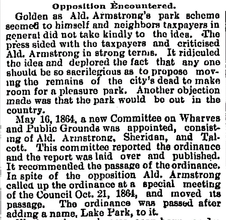
Lake Park to Lincoln Park

who paid ...

In accordance to a book called Chicago: The Garden City by Andreas Simon in 1893

text below - Board of Public Works 1863-1869


A Special Assessment in 1871
to the residents of the Townships of Lake View and North Chicago (then part of Chicago)

A Map View
before the Park Space Existed
map - Barry Lawrence Rudman
only just cemeteries


This 1863 Charles Shober map shows the original park space (yellow), Chicago Cemetery (green), and Catholic Cemetery (yellow) south of the park space.

zoomed below


The zoomed version of the 1863 map of the original park space shows rainwater drainage system called
Lake Shore Ditch later be called the '10 mile ditch'. This ditch was designed to drain the swamp-like environment from the area. This drainage ditch stretched through Lake View Township
view of the original park space

image - The Cultural Landmark Fountain
This original park space was called 'Lake Park'
prior to the assassination of Abraham Lincoln
map below - 'Lincoln Park 1899'

photo below - Hidden Truths:Lincoln Park


The governance of Lincoln Park was established by the State of Illinois in 1869 even though the park space was created years before. This small park would a decade later absorbed the 60 acre cemetery called simply 'Chicago Cemetery' as well as the existing Catholic and Jewish cemeteries. Later in the 20th century the park space would expand northward along the lakefront. The Lincoln Park Board of Commissioners, the governing body for the parkland and the roadways along the lakefront, planned for the park's expansion northward along with the expansion of 'North-Lake Shore Drive' north of the park. The Board of 5 members would link the then 120 acre park with Chicago's neighbor to the north - the Township of Lake View by the early 1870's. While the membership of the Board was split between political representatives of Chicago & Lake View Township the maintenance and expansion revenue was split between two township assessors, Lake View and North Chicago townships (northern Chicago). Early Chicago was comprised of North, West, & South Chicago townships - all current taxing bodies for property assessment to this day even though there has been several attempts to abolish this unit of government - one of the oldest forms of governance in Illinois as well as in many eastern states.
The Topography of the Park by 1860

Lincoln Park

The Political Father
of Lincoln Park


a 1866 view of the park
image - Calumet 412

Not to be Overlook

wood-carving - Ebay
The fire of 1871 was another connection to the Township of Lake View and its residents. The fire crossed the border (Fullerton Avenue) a block or two along the lakefront forcing Chicagoans to find safe-harbor in the township until the rains ended this tragedy.
illustration below - Chicago Rebuilt 1875

.jpg)
.jpg)
The Land North
of Fullerton Avenue
The city of Chicago bought a section of area belonging to Ridgeville Township (1850-57). Lake View Township, a subsection of the old township, was not established not until 1857. At this time the original park was located south of Webster Place.
Note: Ridgeville Township composed of the areas of
South Evanston and Lake View townships.

This 1887 map below shows the land purchased
by the City of Chicago in 1852 but financed by the taxing body of the Township of Lake View and the taxing body of North Chicago Township
The shoreline was still dictated
by the winds/sands from the lake
Raschers Atlas via History Map Works


Territorial Control

In 1853 the State of Illinois granted Chicago land from North to Fullerton avenues setting the stage for the ownership of Lincoln Park, the park. This area was known as North Chicago Township that still serves as a property taxing body in Illinois. With the establishment of Lincoln Park as a park the citizens of North Chicago Township paid the total cost of maintenance for the park land. When the park extended northward past Fullerton Avenue the citizens of both North Chicago and the Township of Lake View paid for the park. The City of Chicago would only agree to contribute cost for police protection for the park. The cost matrix's of the park would change in the 20th century where by the citizens of Chicago would pay for the total costs of the ever expanding park under the authority of City of Chicago and still under the authority the
Below is a map of the townships within the City of Chicago before the annexation of Lake View, Jefferson, Lake, and Hyde Park townships in 1889 - doubled the size of the city.

The City of Chicago was divided into three townships:
South, West, and North with
Lake View Township to its north
map - Chicago & Midwest/Newberry Library

The Park Administration
in 1869
text - Chicago Tribune

of 1898


This 1853 map highlights the area
before the establishment
of Lake View Township (1857-87) & the park itself
map - University of Alabama Digital Collection
via Phelps Fanning & Company
of Lake View Township (1857-87) & the park itself
map - University of Alabama Digital Collection
via Phelps Fanning & Company
(Green Bay Road became Clark Street; Little Fort Road became Lincoln Avenue
by the end of the 19th century.)

When the park space was established north of Fullerton Avenue the taxpayers of Lake View Township joined the taxpayers of North Chicago (near north Chicago) in paying the bills of expansion and
the amenities within the park

Views from 1871
stereographs - Chicago & The Mid-West/Newberry Library
.png)
an apparent bird-eye view
.png)


North-Lake Shore Drive
The Board of Commissioners of Lincoln Park built a drive along the lake within the park ...


This post is my historical review of the relationship between two governmental units - Township/City of Lake View and the City of Chicago with the park, Lincoln Park.
Lake View Township/City and the City of Chicago had joint responsibilities to the park from early 1870's to 1889 as well the financial burdens rested with Lake View Township/City along with the Township of North Chicago. After the annexation the 'old guard' of 5 members remained on the Board years after even after some bitter political infighting about representative taxation. In the early 1870's the expansion of the park was routed north of Webster Avenue to Fullerton and then to Diversey Avenue (Parkway). Fullerton Avenue as of 1853 was always the northern border of Chicago until the annexation of the City of Lake View in 1889. During this time period the park would be populated with monuments of literary masters of Europe that must have been approved by the Lincoln Board of Commissioners. When the park's geography was changed north of Fullerton Avenue the financial responsibility of the park was shared by the Township of Lake View and Chicago. The Lincoln Park Commissioners remains as a functional entity but with much less political authority as it did the the 19th century.
Converting to
more Park Space

Plan of Lincoln Park, Chicago: area, 250 acres /designed by O. Benson, landscape gardener and superintendent. Instead of the North and South Lagoons (original called The Canal') Lake Shore Drive would have had more protection for the unpredictable lake with 'break water' and a lake entrance parallel to Wisconsin Street


a zoomed view from above map with a more zoomed view
of the inlet/bridge area

in more detail
The overall design of the park would remain so until the mid 20th century with the expansion and widening of Lake Shore Drive. The entire layout of park was altered to accommodated Lake Shore Drive
Township of Lake View's Contribution
in 1872


1883

Chicago & The Mid-West/Newberry Library


a more detailed look of this sectional map
via the link above
The Overview

IN SECTIONS:

zoom 2

zoom 3 with a pier in view

Points of Significance:

image 2

image 3

image 4

The Gravel Roads/Walkways
that circled the monuments
postcards - Ebay
.jpg)
While these monuments were erected in later time period I wish to give a idea of what the park look liked before the 1940's
.jpg)

.jpg)
The Park in 1873
map from a book called 'Chicago Lake Shore Drive'
by Neal Simors & Bernard Judge

within the park space


Harper's Weekly 1887

image below - 'Lincoln Park 1899'


The Four Seasons in Lincoln Park
image - 'Lincoln Park 1899'

1893 stereo-view - Detroit Publishing


postcard - part of my personal collection
zoomed from above


text & illustration - Chicago and its Environs 1893


Kids surrounding
the 'Bubbling Cup'
1890's? photo - Chuckman Collection

Winter
in the Park
1900-1909
negatives - Chicago History Museum


that indicated the Chicago's vision/dream of a 'Drive'.
The 'Drive' would be the driving force for an expanded park space beginning with ...
The 'Drive' would be the driving force for an expanded park space beginning with ...
1867 The 'Avenue' along the Shore


1868 image - University of Chicago Digital Map Collection
This 1868 Charles Shober map shows the annexation of Chicago Cemetery and an apparent conversion of the old cemeteries below Lincoln Park. Zoom with a view of the this 1869 map that in detail highlights Lake View Township.
Lake View gets their Pond:
The North Pond
image - 'Lincoln Park 1899'


This last article demonstrates that the township and years later the City of Lake View were interested in a roadway along the lakefront as well. Under the Lincoln Park Act of 1869 a small section of land that was currently part of the township (north of Fullerton Avenue to Diversey) was granted to the Lincoln Park Commission. Because of that the commissioners were chosen ... half from the City of Chicago and and the other half from the Township/City of Lake View so to supervise the expansion and maintenance of the park
& the planned 'drive' northward on planned land-filled space.
1877 Chicago Cemetery
begins to disappear from the current landscape
to Lake View Township


via 1876 U. of Alabama Digital maps
These edited Chicago city maps shows the transformation from cemetery to more park space
The Ten Year Report
These edited Chicago city maps shows the transformation from cemetery to more park space
The Ten Year Report
in 1878-79


image - Lake View 75th Anniversary Magazine
An Erosion Problem
in 1887


The extension phases 1863-73 that expanded south to absorb the cemeteries and then northward
toward the township
image - Art Institute of Chicago via Explore Chicago

from North Avenue to Diversey Avenue


The original park space had neighbors to its' south -
Chicago Cemetery, Catholic Cemetery, and a smaller private Jewish cemetery that included a space for the confederate Civil War dead. The original space expanded first south so to absorb the former cemeteries. The Catholic Cemetery was the last piece to be annexed and converted into park space. The Catholic cardinals' residence marks the south end of their former cemetery and the then park space.

image - 'Lincoln Park 1899'
Built on of the old Catholic Cemetery on North Avenue was the residence of the first Catholic cardinal in Chicago, Archbishop Feehan (1880-1902)
postcard - CashCow

The Governance
of the Park:
The Lincoln Park Board
of Commissioners

views north and south with a view of
top photo toward the left of photo
image - 'Lincoln Park 1899'
They had their own police force

1900s photo - Ravenswood-Lake View Community Collection

and below via Jan Sterling

The Township of Lake View became a city for only two years between 1887-89. The city was annexed to the City of Chicago in June 1889. When the two year old city was annexed in 1889 the existing Lincoln Park board members became citizens of Chicago old habits die hard and their loyalties were squarely with the old city of Lake View and with its new political clout would be a force to be reckon within Chicago's city hall almost a decade after the political & geographical annexation

image - 'Lincoln Park 1899'
The image above is the first expenditure of the Lincoln Board of Commissioners with resident of Lake View Township - John B Turner as its treasurer

above image - 'Lincoln Park 1899'
the below image is of the driveways - Ebay
The Trees within the Park
text below - 'Lincoln Park 1899'

Café Brauer in 1882


The City of Chicago and the Township of Lake View
border was Fullerton Avenue. The North Division was once North Chicago Township

Stereoviews
1880s & 1890s photos - Ebay
Stereoviews are three-dimensional images created by
combining two photographs taken simultaneously and viewed through a stereoscope.
%20(1).jpg)
%20(2).jpg)
%20(3).jpg)
.jpg)
%20(1).jpg)

%20(2).jpg)
%20(3).jpg)
%20(4).jpg)
.jpg)
%20(1).jpg)
%20(3).jpg)
zoomed from above

.jpg)
.jpg)
%20(4).jpg)
%20(1).jpg)
.jpg)
In 1887 May
The article below is about a plan
to create a breakwater

1887 December
begin to complain about the park's levies (taxes)


Chicago Inter Ocean Magazine 1887
this 11x17 sized page is part of my collection

The Park Tax Summary
1870-1899
that indicates what jurisdiction paid for the park
(click to enlarge image)

%20(1).jpg)
a personal photo - Ebay
with the reverse side
.jpg)

a 1893 Rand McNalley map zoomed

map - University of Chicago Digital Maps
The original lakeside road through the park was called 'Breakwater Carriage Drive and Sidewalk Drive' and created as a sorta land-made protection from the storms of the lake

View of roadway between the lagoons & lake from the then existing 'High Bridge' pictured in 1908. The bridge was demo'ed in 1909.
postcard - Ebay

and a closer view below toward Diversey Street (Parkway)

image - University of Chicago Digital Collection
The blueprint lithograph - mid 1880's. The park is extended to Diversey Street (Parkway) with plans to establish a lagoon at Diversey and Belmont Avenues. Diversey was to be the final parks/boulevard link of the city's established boulevard system
- it did not happen due to citizen/business opposition.

The original entrance to the park at St. James Place
images - 'Lincoln Park 1899'

photo above - Detroit Publishing via Ebay
below image - 'Lincoln Park 1899'

a narrative - Chicago and its environs 1893


below image - 'Lincoln Park 1899'

Who Owned it?
the old Huntley property still contested
As early as 1854 Elisa Hundley and James Ree owned property just north of Grace Street to Belmont Avenue (former Davis Street), Broadway area to the existing lakefront which included the now demolished Lake View Hotel. By 1894 the property from Grace Street to Cornelia Avenue was still in dispute. Several folks lay claim to the property including the City of Chicago (riparian rights) since 1889 when citizens of the City of Lake View was annexed to Chicago. Plans for a roadway from Lincoln Park at Diversey northward was planned and a pier was in the way of that development. Sheridan Road would exist as landfill 180 feet into the lake by the end of the 1890s.


District of Lake View Demands
Road Expansion
in 1894


the Boardwalk fence was located just
south of Diversey to about Grace Street


Some Other Views of the Park

Robert Cavelier de La Salle Monument via Ebay
all the monuments were within circular configurations
along the gravel paths

postcard postmarked from the postal station
from in the Old Town Hall pre 1907- Ebay


postcard - Ebay

Negative
Glass Plates
Glass Plates were popular between 1880's til 1920's

part of my personal Lake View collection

Landfill Plan for Bathers & Yachts
in 1896


Lake View is Thirsty
in 1896


A Representation Battle
in 1897


below image - 'Lincoln Park 1899'


The 4th of July Fun
in 1897
with the High Bridge in the background

via Forgotten Chicago Discussion Group


Compromise
Reached in 1897
Lake View gets Representation Once More


by 1897


above image - 'Lincoln Park 1899'
The Kids Beach near
Fullerton Avenue


1899 - Chicago History Muesum
below image of the park unknow date - Ebay

the ponds and land surrounding them
 image - 'Lincoln Park 1899'


photo: Detroit Publishing Co., Publisher. [Chicago, Ill., the lagoon, Lincoln Park] [between and 1910, 1890]
image - Library of Congress
image - Library of Congress
In 1877, Birch Canal was created, connecting Lincoln Park’s North Pond to other water-bodies, which were later reshaped and designated into the Swan Pond and Waterfowl Lagoon. Around these constructed water features, several animal enclosures and buildings were built, and the zoo evolved to include Victorian gardens, undulating topography, meandering paths, rustic bridges, and stands of mature trees. Rather than being set apart from the larger Lincoln Park landscape, the zoological collections were integrated into the park without fences or admission fees. By the early 1900's, enclosures for bears, bison, birds, and sea lions were complemented by pavilions, restaurants, comfort stations, and the Prairie-style Café Brauer, designed by Dwight Perkins and completed in 1908.

'Boat Harbor' probably along the canal
image - 'Lincoln Park 1899'

probably a photo of the Water Station used to maintain
the property grounds within the park
 image - 'Lincoln Park 1899'


the property grounds within the park


1891 photo - Chicago History Museum

The Palm House
Chicago, The Garden City by Andreas Simon 1892 via Forgotten Books in 1995

view from the


images - 'Lincoln Park 1899'
along with a small building


photo of visitors in 1900 - Chicago History Museum

the zoo inventory by 1899
the first animal was a bear purchased in 1874
image below - Chicago History Museum

Animals roam the grounds

More Animals added by 1888

The City takes claim to the Waters
off the Shoreline by 1889


below image - 'Lincoln Park 1899'

(click to enlarge)
images - 'Lincoln Park 1899'

Bridges in the Park

below 1893 postcard - Ebay


crossing over the lagoon & Lake Shore Drive
to the waters edge
some background


2 page photo - Chicago Lake Shore Drive
by Neal Simors & Bernard Judge

The High Bridge was located between North and Fullerton Avenues It was coined "Suicide Bridge" due to the number of folks jumping off the bridge into the lagoon to their deaths
.jpg)
.jpg)
.jpg)
It would appear that this bridge was near Fullerton Avenue due ot the promixity to the Lincoln Park 'open-air' Sanitarium
postcard - Ebay
%20(1).jpg)
.jpg)
a view south from the bridge
.jpg)
poor quality
in sections


Chicago History Museum via Explore Chicago Collection
Negatives - Chicago History Museum


& Lake Shore Drive


An Excursion Ride
to the Park at Fullerton Avenue

Limits of the park and North Lake Shore Drive
was at Fullerton Avenue - see steam boat on one side and the Daily News Sanitarium on the other.

also from the 1900 photo folks debarking from boats.
both photos - Chicago Lake Shore Drive .jpg) heading down from the High Bridge to the ferry
heading down from the High Bridge to the ferry
.jpg)


by Neal Simors & Bernard Judge
.jpg)
.jpg)


Taxes Should be Raised
in 1901
from the property owners


 The Chicago Academy of Sciences
This is the second building opened in 1894
image - 'Lincoln Park 1899'
Asking Lake View
The Artesian Well
in 1901


This is the second building opened in 1894
image - 'Lincoln Park 1899'
Asking Lake View
to Vote for Tax Increase
in 1902


1902 Views
photos - Ebay


Concession Stand in 1902
photo via Southport Corridor News & Events
Canoes in the Lagoon
in 1902


part 2


1903 negative - Chicago History Museum

This 1897-99 Rand McNally map
University of Chicago Digital Collection
This map indicates the proposed extension of the park northward to Belmont Avenue The Diversey & Belmont lagoons were planned. Belmont and Diversey would become 'Yacht Harbors'. Belmont's opened to the public in 1913.
Architecture Antique Art 1902 


Purchase of land to Diversey
in 1903


in 1903
photos from the booklet


photo below - Chicago History Museum

A Plan to Expand the Park
Northward


Views from 1906
Ebay
.jpg)
.jpg)

.webp)
Canoe and Boat Club
by 1908


Chicago History Museum


Chicago History Museum
1906 Negatives


Old Lake View
still Pays for the Park


Lake View, even after the annexation of 1889, still paid for the improvements at Lincoln Park along with citizens of northern Chicago (North Chicago Township). The State of Illinois law of 1869 dictates that these two governmental entities North Chicago Township & Lake View Township are obligated to use their property assessment tactics to collect.


images - 'Lincoln Park 1899'

A Revenue Request in 1900
General Grant Monument
1903-04
photos - Ravenswood Lake View Community Collection


A Visitor
in the Park ...


the inscription in the back of one of the photos
and part of my personal collection

Driving though the Park
1910's??

.jpg)
zoomed from above

Vintage Postcards
of the Park
from my personal collection from 1890's to 1910's


Landmarks in the Park
in 1902

Lake Michigan Coast Chart
in 1903

This map shows the existing lakefront and the ....
(Facebook album)

Mitchell's Real Estate Map of Chicago


A Planned Bathing Beach
set for Fullerton to Diversey in 1910


New Land
to be Created


Land Limits of Lincoln Park
by the 1920's
Belmont Yacht Harbor was opened to the public in 1916 with the park space only reaching to Cornelia Avenue


pumping the water northward

A Map View


1911 U.S. Engineer Department Map

This is a 1911 U.S. Engineer Department map of the
existing lakefront. The blue area indicated a depth of 10 feet of water, pinkish area indicate at least 21 feet, and the outer green more than 21 feet. The park ended at Diversey.


 strolling near the boathouse - north pond 1906
 inside the conservatory 1906
 a lily pond 1908
.jpg)
%20(1).jpg)


 North-Lake Shore Drive


existing lakefront. The blue area indicated a depth of 10 feet of water, pinkish area indicate at least 21 feet, and the outer green more than 21 feet. The park ended at Diversey.
images - 'Lincoln Park 1899'
(click on image to enlarge)
 page 2

page 3

page 4
 page 5


page 6
 page 8

(click on image to enlarge)


page 3

page 4


page 6


The Shoreline Construction
by the City of Chicago
 image - 'Lincoln Park 1899'
a 1898 storm destroyed everything along the shoreline.
A seawall on along the shoreline along with RR tracks that were mounted on it was damaged.

a 1898 storm destroyed everything along the shoreline.
A seawall on along the shoreline along with RR tracks that were mounted on it was damaged.
'The process of planning, development and construction of the lakefront took place over several decades. Shoreline expansion started in the 1890's in the areas that would become Grant Park and Streeterville. However, the major shoreline expansion took place between 1920 and 1940. The process of building out the land along the Lake Michigan shoreline involved driving an outer line of bulkheads away from the original shoreline and then filling behind it with material dredged from the Lake Michigan bottom, sand from the Indiana shoreline, general construction debris, alley waste and even debris from the Chicago Fire, in places up to a mile away from the original shoreline. In 1910, the construction of the existing shoreline protection structures began. From 1910 to 1931, the shoreline protection structures were built along the lakefront from the north side of the city to the south always with the hope of containment.


Snippet of News in 1902
from Richards Tourist Guide to Chicago

Plan to Expand
to Cornelia Avenue


Chicago History Museum
Negatives
Schiller Monument dedication 1909

.jpg)
zoomed below
%20(1).jpg)
1908 photo - Ebay
.jpg)


.jpg)
1910 Photos of the Park
Chicago & the Midwest/Newberry Library


The other responsibility of the Lincoln Park Board of Commissioners was the construction of a roadway along the lakefront. We know this road as Lake Shore Drive.
(click to enlarge image)
 images - 'Lincoln Park 1899'
 Expansion
(click to enlarge image)


by 1916
 images - Lincoln Park Board of Commissioners Report 1913-1916
 view is north of North Avenue
 view of the original baseball diamonds
1927 photos - Vibecke Knudtzon Gausel
via Pictures of Chicago-Facebook
view of the original Lake Shore Drive and original canal
 WPA Project 1937-1942


Lake View Still Paying
for the Park in 1916
 images - Lincoln Park Board of Commissioners Report 1913-1916


Bathing Beach
at Waveland Avenue Planned


The Park
by 1927

1927 photos - Vibecke Knudtzon Gausel
via Pictures of Chicago-Facebook
view of the original Lake Shore Drive and original canal

A More Direct Roadway Link Though the Park
It finally took destructive storms in 1929 in both Spring and Autumn along with stimulus monies during the depression of the 1930's to realign a more direct roadway link around the park. This new link finally and directly link-up the Loop area of the city to its northernmost point at the time, Foster Avenue. City planners would use the existing 'Break Water and Carriage Drive' as the new extension of Lake Shore Drive. The federal government granted construction aid between 1937-1942 to not only widen but expand further the 'Drive' along the shore. The federal dollars were used to realign the existing park making it more car-friendly. These monies today would be called stimulus package from the Federal government in Washington DC.


Pre-realigned image of the park space as of 1935

Lincoln Park realignment by 1942 post alignment
- both photos Hidden Truth
- both photos Hidden Truth
So, by 1942 parkland and harbors were created by landfill along the man-made shoreline with governmental assistance where, at one time, there were cliff formations, small bluffs, and


via Explore Chicago Collection

via Explore Chicago Collection

Chicago History Museum via Explore Chicago Collection

via Explore Chicago Collection
'The zoo was founded in 1868, when the Lincoln Park [Board of] Commissioners were given a gift of a pair of swans by Central Park's Board of Commissioners - New York City. In 1874 the swans were joined by a bear cub from the Philadelphia Zoo; the first animal purchased for the zoo. The bear became quite adept at escaping from its' home and could frequently be found roaming Lincoln Park at night.' [from 1873 Chicago & Lake View Township had joint responsibility of the park/zoo through the Lincoln Park Board of Commissioners] - Wikipedia edited

image below - 'Lincoln Park 1899'

Population of the Zoo
in 1893
Chicago, The Garden City by Andreas Simon 1893

Another Perspective in 1899


Contributions to the Zoo in 1899

page 2


.jpg)
.jpg)
The Zoo Keeper - The Boss
one of the most dominate figures of the park


below photo - Chicago History Museum
via Explore Chicago Collection

An Account 1893
Chicago:The Garden City by Andreas Simon

Mr. W.C.Goudy was a resident of Lake View Township who was the first president of the original Lincoln Park Board

Some Early Postcards
of the Zoo
from my personal collection


Conservatory

images - Chicago, The Garden City by Andrea's Simon
The original conservatory was called the 'Palm House'
- to the right of this photo with its outside garden space


The New Palm House
 the new building, constructed by 1893
image - Chicago, The Garden City by Andrea's Simon

images - Chicago, The Garden City by Andrea's Simon
The original conservatory was called the 'Palm House'
- to the right of this photo with its outside garden space


The New Palm House

image - Chicago, The Garden City by Andrea's Simon
An Artist View in 1890
the architect was Joseph Lyman Silsbee

‘The Lincoln Park Commission constructed the Lincoln Park Conservatory in phases between 1890 and 1895, replacing a small greenhouse that dated from the 1870's. Nationally renowned architect Joseph Lyman Silsbee designed the Conservatory in collaboration with architect M.E. Bell. A "paradise under glass," the Conservatory supported "a luxuriant tropical growth, blending the whole into a natural grouping of Nature’s loveliest forms. "Historically, aquatic plants propagated in tanks in the Conservatory were planted outside, in artificially-heated lily ponds. The exotic plants were so popular that in 1897 the Egyptian government requested seeds from Lincoln Park's water lilies. The rocky-edged ponds once meandered along what is now the fence line of the Lincoln Park Zoo.’ - Chicago Park District
postcard view below - Benjamin Yolarski via 'Chicagoland Before We Were Born'-Facebook in 1910

The Floral Report by 1899

The Floral Report by 1899

images - Lincoln Park 1899


1902 photo inside the new building
photo - Chicago History Museum
via Explore Chicago Collection

photo - Chicago History Museum
via Explore Chicago Collection

1903 photo inside the new building
photo - Chicago History Museum
via Explore Chicago Collection
The Garden Report


Lake View & the Outer Drive
image - 'Lincoln Park 1899'
The plan began in 1874 but noting was accomplish
with a little bit of drama mixed in ...
 The Park by 1899
take a closer view from the link above
image - 'Lincoln Park 1899'

 before the re-configuration of the 1940's
 The Monuments
image - 'Lincoln Park 1899'
The plan began in 1874 but noting was accomplish
with a little bit of drama mixed in ...

take a closer view from the link above
image - 'Lincoln Park 1899'

A Postcard View


in the Park

These monuments mentioned in the post were mostly commissioned and installed prior to 1910. The administration of the park was shared with the citizens of old Lake View and the rest of Chicago while the revenue for the park was raised and administered by the residents of assessment district of Lake View & North Chicago Townships This arranged began when the Lincoln Park of Commissioners (governing body) expanded the park space north of Fullerton Avenue northward. The governmental integration of the old township with the City of Chicago probably took a decade or more to resolve.
The Lincoln Park Board of Commissioners to this day still hold meetings probably less argumentatively from the days of battling riparian rights, outer drive plans, and the battles of power & influence of the 19th century tribal politics.


 photo - Public Art of Chicago
1900 photo - Benjamin Yolarski via 'Chicagoland Before We Were Born'-Facebook


images - 'Lincoln Park 1899'


A 1923 map of the park
showing Montrose Harbor as a planned development
(click on map to enlarge)

List of Monuments
of Lincoln Park:
photo - Andrew Horne

German-Americans were abolitionists hence
Lincoln Republicans

Prussia part of Germany in Europe


1900 photo - Benjamin Yolarski via 'Chicagoland Before We Were Born'-Facebook


photo above - Alan Scott Walker


photo below - Calumet 412

initially called
The Indian Monument


photo above - Allan Scott Walker
photo below - Equestrian Statues

photo below - Equestrian Statues

photo - Wikimedia Commons

photo - Chicago and its Environs 1893

photo - Allan Scott Walker

Originally located on Fullerton Avenue in the park north the original conservatory once called 'The Palm House' and much later moved
to Midway Plaisance in 1976.
postcard - Ebay

photo - Jennifer Ames


photo - Allan Scott Walker
 Other Notable Monuments

after 1900:
a gateway to neighborhood of Lake Viewto the south

photo - Public Art in Chicago
a postcard view of the installation celebration below

.jpg)


negative & text - Chicago History Museum

photo below - Alan Scott Walker

photo - Andrew Home


photo - John Angel
the first version
.jpg)

the second version

photo - Alan Scott Walker

Monuments Once Located
in the Park
photos - The Chicago & Midwest/Newberry Library

in Lincoln Park


The Sphynx

zoomed from above

City of Chicago Monuments
by 1910
Moran's Dictionary of Chicago 1910


Resource


it begins in the park
The Drainage Ditch
through Lincoln Park
& Old Lake View
While looking at some vintage maps of the second half of the 19th century I continued to see this line in each map called the 'Lake View Ditch' to be later referred to as the '10 mile ditch' due to the fact it stretched from Township of Evanston (Devon Avenue was the border at the time) to northern Chicago. The ditch was a water/drainage ditch that worked as a sewer from constant storms from Lake Michigan overflow. The drainage ditch dug initially meant to keep the land in particular Chicago Cemetery dry as well as the Catholic & Jewish areas.

image - 'Lincoln Park 1899'
The location of a cemetery along the lakefront may have seen scenic but it became apparent that it did not work-out so well when the winds & waves of the lake would crash to the shore sometimes with vengeance during a storm. The dirt covering the remains of loved ones would wash away and the interred would surface. After a while the medical field discovered the connection between interred and lake drinking water. The interred were removed from the city limits into cemeteries of the Township of Lake View beginning in the late 1850's. The ditch became obsolete covered & forgotten.

a David Rumsey map 1869 edit
the red highlighted area indicate the border
between City of Chicago & Lake View Township
In 1869 the park was governed by the Lincoln Park Board of Commissioners. In accordance to a 1869 map the 10 mile ditch stretched from North Avenue through the original/initial the park area toward & through southern portion of Lake View Township ending apparently north of Wilson Avenue.

this is zoomed view of David Rumsey 1869 map edit highlights the continued route of 'Lake Shore Ditch' through the township as well a roadway called 'Lake Shore Plank Road' known day as Broadway. The zoomed David Ramsey map below has the ditch fading away somewhere north of Wilson Avenue once known as Shippey Road. I have published a post about the cemeteries that were established in Lake View Township that was a direct connection to the failed location of cemeteries along the existing lakeshore called Cemeteries of Old Lake View. It is my contention that old Lake View would have been a ‘back-water’ township for several more decades and its interest to annexation to the City of Chicago delayed or non-existent.

The Park Plan Expansion
to
Belmont Avenue in 1893


this 1913-15 map of the proposed extension of the park
is part of my collection


Lincoln Park Extension
by 1927
photos - Chicago & the Midwest/Newberry Library
view north from Stratford Place

the Montrose breakwater view below


The Equipment
used to Move the Water

A Threat to Fund
in 1903
The City of Lake View was annexed in 1889
but its taxing authority was still in place


Still a Taxing Authority
in the Northside


Post Notes:

This WTTW video
highlights how parks were designed for urban dwellers in America from the very beginning

There is an earlier version online about
Lincoln Park.
Listen to a tale of the lost and forgotten burials in park.
Important Note:
These posts are exclusively used for educational purposes. I do not wish to gain monetary profit from this blog nor should anyone else without permission for the original source - thanks!
No comments:
Post a Comment
Email me at lvhistorical@gmail.com