
Take a View
of Old Lake View:
Vintage Fullerton Avenue
These negatives are along Fullerton Avenue
Fullerton Avenue was once the border between township/city of Lake View and the City of Chicago
negatives- Chicago History Museum
Lincoln Avenue north of Fullerton Avenue
at Halsted Street
photo - Chicago History Museum
Lake View Avenue & near Fullerton Avenue
below postcard - Garry Albrecht
The Augusta Lehmann
Estate
Lake View Avenue & Diversey
southwest corner
Constructed in the District of Lake View
J. L. Lehmann Family owned the a department store in the Loop area called the Fair - it was compatible to a Marshall Fields or Sears. When old man Lehmann died in 1900 he left one million dollars to his wife and later to his children. The Lehmann clan would own several luxurious homes in Lake View. 1891 Rascher's Atlas Map
zoomed from above
photos - Greta Cross Elks National Memorial HQ & Grand Lodge
below are Sanborn Fire Maps
this is the view in 1894 that highlights
the mansion property
The stone constructed building
dates prior to 1896
1923 Sanborn Fire Insurance Map The map below reads 'site of Elks Memorial'
zoomed from above
The Area View
from the Rascher Atlas 1887 map
(vacant land)
view from Lake View Avenue above
view from their side-yard below
Carey Wintergreen Research:
Mrs Augusta Handt Lehmann Residence
Architect: Edmund R Krause
Ironwork: Chris Muth
▪️1890 | Mrs Lehmann commits her husband…Ernest Johann Lehmann…founder of The Fair Department Store…to the Bloomingdale Asylum for the Insane | White Plains NY
▪️Prior to 1894 | Mansion constructed
▪️1902-05 | Mrs Lehmann purchases and remodels mansion
▪️1918 | Mrs Lehmann dies in an elevator accident in her home and is interred at Graceland Cemetery
▪️1923 | mansion demolished
From a Mansion to
an Memorial
Elks National Memorial
A Gateway to the
Community of Lake View
built by 1923
photo via David Augustus Forgotten Chicago-Facebook
This memorial to veterans is located on the southwest corner of Diversey Parkway and Lake View Avenue was once located in the District of Lake View prior to the creation of official neighbors
by the City of Chicago by 1930,
hence part of this blog post.
images above - Art Institute of Chicago
zoomed from above
1926 dedication ceremony - Ebay Chicago History Museum 1926 Chicago Daily News photographer1927 photo - University of Illinois-Chicago
via Explore Chicago
(to enlarge)
caption reads on postcard:
'This magnificent building at Lake View Avenue and Diversey Parkway, north entrance to Lincoln Park was erected as a memorial for the Elks who gave their lives in the world war. It houses the National Grand Lodge offices of the B. P. O. E. The approximate cost of the structure is $3,000,000,00.' postcard - Ebay
Constructed in the District of Lake View
located south of Elk Memorial
in the Community of Lincoln Park
image - Google Earth
text - City of Chicago1923 Sanborn Fire Insurance Map zoomed from above
images - City of Chicago
These townhouses
were originally built for the following:
Abram Poole, Henry C. Dangler, Ambrose C. Cramer,
and Mrs. Arthur Ryerson in 1916-17
A Connection to the Titanic

all images - Art Institute of Chicago

Original Views
by The City of Chicago

A 2017 DNAinfo Article
by Ted Cox
The Lake View Avenue [a street once ranged from Fullerton to Belmont] Row Houses near Diversey Parkway are being restored to their Georgian glory, potentially as a massive single-family home called Adler on the Park. The four row houses, 2700-10 N Lake View Avenue already had been designated as a Chicago landmark. Built in an attempt to bring the charm of British Georgian town houses to Chicago just at the northwest edge of Lincoln Park, they contain a lot of Chicago history as well. "It's a great, great piece of Chicago history," said Bob Berg, president of Foster Design Build, which is handling the project. David Adler designed the original row house at 2700 N. Lake View for Emily Ryerson, widowed when her husband, Arthur, went down with the Titanic in 1912. It was a terrible year for the family of the Chicago steel magnate, as they were returning from Europe immediately after the death of Arthur Jr. in an auto accident. They booked passage on the Titanic, and after it struck an iceberg, Arthur Ryerson obeyed the order of women and children first and ushered his wife and three other children to the lifeboats and stayed on board the ship. Arthur Ryerson went down with the ship along with its more than 1,500 other victims. His body was never recovered. Emily Ryerson, however, returned to her position in Chicago society, and three years later commissioned the project to build a set of row houses for herself and a few artist friends in the Georgian manner.

David Adler was credited with two, his architecture partner Henry Dangler with another, and Ambrose Cramer with the last. According to the "AIA Guide to Chicago," Dangler had to sign Adler's drawings because he never passed the engineering test necessary to become an architect. Adler, however, gets full credit in the name for the Adler on the Park development, in which it could be reconfigured into one massive 16,000-square-foot home or kept separate as three condominiums. A ballroom and large parlor remain intact and will be retained. "Anyone who seizes this opportunity now is able to custom design the interior," Berg said. "The opportunity also exists for this home to become three very large, wide-open, luxurious condominiums — each 5,000 square feet — that retain key design features. "We're going to go down both tracks and see what the market dictates," he added. The homes are on the market through @properties, with Berg estimating the asking price at $3.5 million to $4 million if separated into three condos, or $9.5 million to $10 million if kept whole. At that, it would be comparable to the Wrigley Mansion down the street at 2466 N. Lake View, only with "more flexibility" in how it might be oriented by a buyer, he said. Berg also touted tax breaks that accompany the site's landmark status. Architect Tim Le Vaughn is set to design the renovation however it's arranged. Preliminary work on the exterior is underway, and Berg said crews hope to begin the actual renovation in two weeks, as soon as the city approves permits. Berg said Foster Design Build "takes on unique, significantly historic properties. We like to save them and help neighborhoods retain their character."
Interior Views in 2013
all photos via Curbed Chicago


 currently called
In 2017-18 these buildings were renovated into two grand residences for modern living
2017 renditions - Wendy Berg Real Estate
 renditions via DNAinfo
Photography
by Cory Steinberg 2023
2700 N in 1917
The Homes along
Arlington Place
2466 N Lakeview Avenue
constructed in the District of Lake View
1900 image - Art Institute of Chicago 1900 image - Art Institute of Chicago'What's known is that the Wrigley Mansion in Lincoln Park was built in 1896 by architect Richard Schmidt for beer baron Joseph Theurer, owner of the Schoenhofen Brewing Company. He sold it to William Wrigley Jr., the chewing-gum magnate, in 1911, and he sold to his son P.K. in 1922. P.K. Wrigley and his family moved out in 1931, but retained ownership past his death in 1977. It was sold to Nicholas Jannes in 1984 after the city had quashed an attempt to demolish it to make room for an apartment high-rise, then rushed to grant it landmark status in 1979.' - DNAinfo
1923 Sanborn Fire Insurance Map zoomed from above

1940's photo - Art Institute of Chicago2018 Interior Views
the other grand homes
in the area
and
in 1927
undeveloped land below
featured in a 1889 Chicago Daily Tribune article
A Residence
north of Berteau
along Paulina Avenue(exact address location unknown)
My thanks to Ryan Martin for these photos
Grace Street &
Sheridan Road Views
the inner drive from Belmont to just north of Grace Street was Sheridan Road from 1894 to 1931
Sheridan Road (inner Lake Shore Drive)
& Grace Street - view south
1910 postcard - Ebay
in the mid 1890's North-Lake Shore Drive was renamed Sheridan Road from Diversey to just north of Grace Street only to renamed back to (inner) Lake Shore Drive by 1931 and before the mid 1890's
Lake View Avenue ended at Belmont
sectionals of the postcard above & below
lamp post reads Grace Street
Another view of Sheridan Road at Grace
another Lehmann house in the background at Waveland
image - Ebay
and yet another view
1912 photo - University of Illinois-Urbana/Champaign
and yet another view below
1916 postcard of the boardwalk- Ebay
another view of it by Grace Street photo - Ravenswood-Lake View Community Collection
When Sheridan Road curves to the West
1903 photo below - Chicago History Museum
Sheridan Road view west from the lakefront
Just north of Grace Street Sheridan Road is routed west toward Sheffield Avenue and then north again. At that intersection Sheffield was renamed Sheridan Road northward.
1912 negative below - Chicago History Museum
Sheridan Road with the lake in the forefront making the curve west.
1912 negative above - Chicago History Museum
lakefront to the right; Sheridan Road curves west
and
1913 negative below - Chicago History Museum
Sheridan Road view southeast towards the lake
1909 photos below - Rand McNally Photo Auto Guide
Sheridon Road & Sheridan Road intersection
with Sheffield Avenue to the right of the photo
the Sheridan Road & Sheridan Road intersection; arrow as indicator
with Google Map View of it
Sheridan Road routes north again
The Sudner House
Buena & Evanston Avenues
Community of Buena Park
unknown date
photo - Chicago History Muesum
1894 Sanborn Fire Insurance Map District of Lake View
(City of Lake View was annexed in 1889)
E.J. Lehmann Jr.
Estate
son of the founder of the Fair Department Store
and VP of the store
Mother was Augusta Lehmann
*father and son had the same initials*
Sheridan Road (inner LSD) / Waveland
photos via Kevin Peterson-LakeView Historical
probably initial source is Chicago History MuseumThe Lehmann Family owned
The Fair Department Store in Chicago from 1892-1984. The family mansion was located at 3662 N. Sheridan Road - in 1931 this segment of the road was re-named to inner Lake Shore Drive.
1914 Examiner article
1923 Sanborn Fire Insurance Map
Convalescent Home
called
Waveland Manor
once along former Sheridan Road (inner LSD) on the south-side of Waveland Avenue now part of the New York apts
postcard - Ebay
Waveland Manor was a convalescent home located at 3662
Lake Shore Drive in Chicago, operational from 1952 until its demolition in
1973. The building was previously a Lake Shore Drive mansion that belonged to EJ Lehmann family who owned several properties in Lake View at the turn of the 20th century.

a 1956 article
a 1963 article
(Sheridan Road was renamed (inner) Lake Shore Drive in 1931 from Belmont Avenue to Irving Park Road)
The Edith Lehmann Behr
Residence
1914-mid 1960's
daughter of EJ Lehmann & Augusta Lehmann,
construction phrase of 505 Stratford Place
images - Kevin Peterson via Construction News Magazine
The main entrance was on Stratford Place. The main gate entrance is still there with its original gates that now surround a parking lot for Temple Sholom. A back entrance to the property (parking lot) is on inner Lake Shore Drive
The Temple Sholom was not built yet
2021 text & photo by Carey Wintergreen
1914-1967
R.W.R. Capes via Tom Morrisey, Original Chicago-Facebook
Benjamin Leslie [& Edith] Behr Residence
Now: Temple Sholom parking lot
505 W Stratford Pl corner of N Lake Shore Dr
Later known as: 3466 N Lake Shore Dr
Architect: George W Maher
Style: Italian Renaissance
▪️1914 | Behr constructs a 15-room mansion
▪️1942 | Mansion purchased by Harriet Henry Young
▪️1950 | Mansion converted to 7 apartments
[1961 Mansion purshased by Temple Sholom]
▪️ 1967 [or shortly after] | Demolished
the view of the fence/car entrance today
along inner Lake Shore Drive - former Sheridan Road
of Old Lake View:
Hand-colored photograph and sketch for Aldine Avenue on
page 57 of an album that contains colored photographs of streets in Chicago and
sketches of street name clues. The album was created by Mr. and Mrs. F. E.
McCleary for a contest published in the Chicago Examiner in 1910. [Evanston Avenue is currently Broadway since 1913]
1891 Rascher's Atlas Map
Wolfram & east of Mildred Avenue
postcard - Ebay
Wrightwood & Clark Street
known then as the District of Lake View
1908 postmark - Ebay
postcard - Calumet 412
Sheridan Road view east toward the then
existing lakefront. Horse/Carriage & automobile making the curve west from inner Lake Shore Drive
(also once called Sheridan Road prior to 1931)
Northeast corner of Clark & Belmont
1910 postcard - Ebay
Nichols Dry Goods Store
Irving Park Road & Sheridan Road - Ebay
Carmen Ave west of Ashland - Ebay
1600 block of Grace Street - Ebay
1925 photo - Newberry Library
825-35 Cornelia Avenue
postcard - Ebay
pre 1909 address 1547-55 W Bradley Place
post 1909 address 809-811 W Bradley Place
postcard - Ebay

Looking toward the Brewster Apartments
(formerly known as the Lincoln Palace)
on Pine Grove from Wrightwood Avenue
postcard - Ebay
Pine Grove looking east from Surf Street - Ebay
Pine Grove looking north towards Irving Park Road
postcard -Ebay
Pine Grove Avenue north of Sheridan Road
postcard - Ebay
Melrose east of Lincoln Street (Wolcott Ave)
postcard - Calumet 412
1549 W Diversey Parkway
photo - Lake View by Matt Nickerson
Clark Street north of Belmont Avenue
postcard - Ebay
 Perry north of Irving Park BoulevardPerry = Greenview Avenue
 postcard - Ebay

Hudson & Belmont avenues
and below
Sheffield view east from Waveland
postcards - Ebay
Sheffield Avenue north from Waveland Avenue
postcard - Ebay
Diversey near Burling Street
postcard - Ebay
called Charles R. Childs Revisited
by Perry Casalino
Clark & Evanston Avenue (Broadway)
and below
Addison Street & Reta
Curran Building Apartments on the NE corner and Sheridan Road and Sheridan Road - 1903 Corner of Reta Street and Addison Avenue - 1900?
Corners of Broadway (Evanston Road < 1913), Clark Street (Diversey Parkway is out of frame/bottom of photo) - 1909
The 'Morris Apartments' on York Street (Surf Street) west of Evanston Road (Broadway) - northwest corner after 1909
The Hampton Apartments
on the corner of Sheridan Road and Dakin
From a Humble Home
to Mansion on the Corner
543 Evanston Avenue
(Broadway)
pre 1909 address
Rascher Atlas 1887 Map
X marks the spot
Sanborn Fire Insurance Maps 1894
zoomed below1923zoomed below (video)
aka

postcard - Chuckman Collection
Joseph E Tilt
'The J.E. Tilt Shoe Company produced boots for the U.S. military, and the firm's large sales force placed thousands of pairs of Tilt-manufactured footwear in dry goods store across the Midwest and Great Lakes regions. By the late 1880s, with his income on the rise and the introduction of his higher quality "Diamond T" brand of shoes, Tilt purchased a large plot of land north of Chicago in the city of Lake View, at the southwest corner of Addison Street and Evanston Avenue - today's Broadway. The 4-acre parcel ran 234 feet along the west side of Evanston from Addison south to Brompton Avenue, 274 feet west on Addison, and 409 feet along Brompton, comprising one-half the entire city block. He built a large, 2-story house at the northeastern corner of the lot, and a green house that was almost as large as the house. At the time, Tilt, his wife, and six children, had very few neighbors.' - Chicago.Designer

This mansion located on the corner of Addison & Broadway is occupied by the Salvation Army as their training facility. The initial occupant was the Joseph E. Tilt Family from 1914 until 1920.

photo - Choose Chicago
above images - East Lake View by Matthew Nickerson
The West Point of the Salvation Army Organation
Chicago Tribune via Chicago Public Library - 1973
A Tour in 2014
photos by Chris Redbeard and Carlos Cuevas
The photos below are from a tour of the mansion that took place in October 2014. These photos were shared on my Facebook page called Lake View Historical.


Many thanks again to Chris and Carlos, contributors to my Facebook presence called LakeView Historical!
Other Tour Photos
photo - Eric Allix Rogers via Open House Chicago
photo - Eric Allix Rogers via Open House Chicago
photo - Eric Allix Rogers via Open House Chicago
photo - John Keating Jr. via Forgotten Chicago-Facebook 2016 tour photos - David S McCoy aka
The Stout Family Estate
1917-1959
a Century of Progress postcard - Ebay
1923 Sanborn Fire Map highlights the buildings that was surrounded by a six foot cement fence
 1936-7 IDOT photography
R.W.R.Capes via Tom Morrisey, Original Chicago-Facebook
R.W.R. Capes via Tom Morrisey, Original Chicago-Facebook
1936-7 IDOT photography
R.W.R.Capes via Tom Morrisey, Original Chicago-Facebook
R.W.R. Capes via Tom Morrisey, Original Chicago-Facebook and below
the main entrance was on Briar Place
from R.W.R. Capes via Carey Wintergreen
Frank D. Stout upon his death in 1927
Death Notice
He Left a Few Bucks
The Son Must Prove His Worth
photo below - Robert Zamora
Then It Became a Hospital
Years after the Stout family sold the property the main mansion became a hospital but had various zoning issues from 1944 to 1955 according to the articles below Razed in 1959
Hospital Quits in 1954
a magazine featured this
mansion page 486-88

another cement fence enclosure
was locate a block south on Barry AVENUE
1927 photo view
zoomed map below - an eight foot fence
a before and after comparison
by Robert Zamora
a contributor to LakeView Historical/Facebook
342 W Oakdale Avenue
apparently built in 1914
The Chicagoan 1931cut & zoomed below
The Chicagoan 1931 zoomed image
The Chicagoan 1931 zoomed image 1923 Sanborn Insurance Fire Map
For Sale
The Chicagoan 1932 below
for Sale or Long-term Rental
1932 Chicagoan ad
1894 Sanbor Fire Insuramce Map
if built in 1894 the building would have had a lakefront view before Sheridan Road, Lake Shore Drive
and the park this north
484 W Wellington Avenuepre 1909 address - 1900 Wellington Avenue
image - Art Institute of Chicago
built in 1892
1894 view from Sanborn Fire Maps with a 2019 Google view below
The Corner of Pine Grove
& Diversey
view west from Pine Grove

Sheridan Road &
Irving Park Road
southeast corner

2019 Google view
448 W Barry Avenue
pre1909 address was 1912 Barry Avenue


The Last Owner
photos below - Ebay
Possible Demolition
in 2017


and then saved by the City Council that same year
all but one photos from Curbed Chicago


The current owner/developer will be converting
this entire house into individular apartments as of 2021
2022 photos - Marc Roger Charles M Netterstrom House
833 W Aldine Avenue
This 3,210 square foot house sits on a 8,861 square
foot lot and features 3 bathrooms. This property was built in 1886. Based on
Redfin's Chicago data, the company estimated the home's value is $1,536,698 in 2018 and according
to Zillow last sold for $363,000 in August 1996.
photo via Curbed Chicago
'The home has been well-maintained and preservationists say its one of the only remaining examples of early architecture in Lakeview before the neighborhood was annexed into the city. The house sits on an unusual triangular lot and has a distinct roofline as a result of the additions Netterstrom made throughout the 1890's. A corner tower, two frame bays and a south section were added to the original L-shaped footprint. The building materials and structure of the house, especially on its north and west gable walls, showcase the Italianate style. So do the home’s common brick, cast stone and windows with subtle arched window hoods and keystones. The Queen Anne elements were added later—like the pressed metal cornice and pediments on the house.' - Curbed Chicago
1887 Sanborn Fire Insurance Map

Edward E Gray Residence
photos - Art Institute of Chicago
built in 1891 pre 1909 address 1922 Belmont Avenue
post 1909 address 438 W Belmont Avenue
1894 Sanborn Fire Insurance Map

About the Owner in 1895
It's 1947 proposed replacement
3 photos - Art Institute of Chicago
G.W. Maher - architect
built in 1893
 2015 photos - David D Nims details still remain

photo - Ravenswood-Lake View
Community Collection
Exterior view of Crowder residence at 4732 N Paulina. The house is on stilts and may have been moved to 4732 N Paulina. Richard L.
Crowder came to the United States from England. In 1873 he became the first
postmaster in Lake View. He was a printer and engraver. He died in 1928.
The Mary Wilke Residence
District of Lake View
1938 W Wrightwood Avenue
pre 1909 address
418 W Wrightwood
post 1909 address
photo - Art Institute of Chicago
Built when Lake View was a city and the border
with Chicago was Fullerton Avenuea 1894 Sanborn Fire Insurance Map that indicates the location of the residence but by 1918 the residence was gone replaced by an apartment hotel called The Shore Crest
per this 1923 Sanborn Fire Insurance Map below
The Shore Crest Apartments from above map
L.R. Williams Residence
District of Lake View
1901 Wrightwood
pre 1909 address
post 1909 address of
455 W Wrightwood Avenue
photo - Art Institute of Chicago
1891 Sanborn Fire Insurance Map of the area
zoomed view of the house to the rightMarshfield Avenue
north of Cornelia
postcard - Ebay
of 1918
on Lincoln Avenue toward Nelson Avenue
& the old Ravenswood L - view south and below
And about Snow
in 1967
on Commonwealth Avenue
photo- Art Institute of Chicago
4223 North Hermitage Avenue(previously 2420 Commercial)
photo - Ravenswood Lake View Community Collection
via Explore Chicago
Evanston Avenue Livery
Boarding Stables
apparently for sale
213 Evanston Avenue
post 1909 address of
3134 Broadway
photo - Chicago History Museum
1894 Sanborn Fire Insurance Map
zoomed from above
Addison & Janssen
date unknown
Ravenswood - Lake View Community Collection
Sheffield looking
north of Waveland Avenue
1907 postcard - Calumet 412
Hermitage and
Ravenswood
unknown date
with the Abbott residence to the right - Ebay
within the then District of Lake View 1948 W Barry Avenue - pre 1909 address
408 W Barry Avenue - post 1909 address
1630 George Street
(Briar Place)
1910 - Chuckman Collection
Oak Grove Avenue
(Patterson Avenue) west of Clark Street
postcard - Ebay
1923 Sanborn Fire Insurance Map of the street
408 W Barry Avenue pre 1909 address was 1948 Barry Avenue
built in 1891
District of Lake View
image - Art Institute of Chicago
pre 1909 address 2541-45
built 1900-03
District of Lake View
image - Art Institute of Chicago of Reverend Braithwaite
with an infant
900 block of W School Street
Aldine Street was once part of School Street east of Clark

End of the line of the old township/city and district of
Lake View was at Devon Avenue at Broadway - 1906 Lincoln Avenue west of Seminary - Calumet 412
 Before & After
532-38 Roscoe Street
a courtyard building
to a 4+1 apartment building photo - Google Maps
The Lake View Laundry
3018 N Clark Street postcard - part of my collection
 1923 Sanborn Fire Insurance Map built in 1909 per map
zoomed view below
from an alley to driveway to a parking lot
that once connected Clark with Halsted Street
Hanson's 'Wet' Wash Laundry
3505-19 Southport Avenue
postcard - Ebay
Belmont Avenue west of Clark Street in 1911
photo - Calumet 412
Pine Grove Avenue north from Grace Street
postcard via G. Schmalgermeier
Graceland Boulevard (Irving Park Road)
east of Pine Grove - 1911
postcard - Calumet 412
Herndon (Lakewood) south of Grace in 1908
postcard - Calumet 412
photo - Calumet 412
Roscoe Street east of the Clark street and the L tracks
1909 photo with a 2016 Google view
were just yards away west and of 2021 any memory of this station gone with the construction
of the Belmont Overpass
photo - Calumet 412
Montrose Avenue looking west toward Ravenswood Avenue
in 1905 two years before the
old Northwestern Elevated Railroad was constructed
postcard via Southport Corridor News & Events
Ravenswood-Lake View Community Collection
pre 1909 address of 2167 Paulina
Ravenswood-Lake View Community Collection
Newport Avenue east of Herndon (Lakewood) in 1905
postcard - Chuckman Collection
Hermitage north of Grace in 1909

postcard - Ebay
I was able to sorta date this postcard by looking at the backside of the postcard that has the publishers address of ‘1049 Lincoln’ which is a pre 1909 address.
photo via Southport Corridor News & EventsStreet Scenes via the Chuckman Collection
his postcards
Barry Avenue
west of Pine Grove
Lincoln Avenue
west of Seminary Avenue
Aldine Avenue west of Sheridan Road (inner LSD)
north of Waveland
Seminary
south of Belmont
Southport Avenue
south of Grace Street
southeast corner of
Montrose & Hermitage
northwest corner of
The northwest corner of
Clark Street & Barry Avenue
west of Evanston Avenue (Broadway)
pre 1913 postcard -Ebay
with a current Google view
This postcard was published prior to the street name change to Broadway in 1913. Without the reverse side of the postcard
for the postmark I have no better date.
southeast corner of Irving Park Road/Sheridan Road
image - Carey Wintergreen via Forgotten Chicago-Facebook
Intersection of Belmont and
Clark Street

view northeastward direction - unknown date
photo - Magnus Jonason via Forgotten Chicago-Facebook
Sheffield Avenue
north of Waveland
photo - Ravenswood-Lake View Community Collection Belmont Avenue
east of Seminary
1908 photo - via Ashaq Hani from Northwest side of Chicago on Facebook
Montrose & Lincoln Avenues??
photo - Calumet412 within the District of Lake View 1908
small print read 'Lincoln'
with possible 2019 Google view below
Newport Avenue
near Lincoln
toward the elevated in 1915with a 2019 Google view below
south of Belmont avenues
postcard - Ebay
Racine
south of Belmont avenues
postcard - Ebay
Wellington
west of Sheffield
Chateau Apartments
819 Sheridan Road
Sheridan Road
west of Broadway
1907 postcard - Library of Congress
1824 George Avenue
pre 1909 address
538 West Briar Placepost 1909 address
George Ave was east of Evanston Avenue (Broadway)
Briar Place extended to the lakefront by 1923
.jpg)
1887 Sanborn Fire Insurance Map
general view of the area
X marks the spot
1909 address changeThe Turner (farm) Residence
His home above
zoomed from above
and
One of the founders of
First Methodist Church of Ravenswood
currently called the
located at 1946 Belmont
a pre 1909 address
in Lake View Township and built in 1860-ish
1894 Sanborn Fire Insurance Map
a general area view
a zoomed view
if the house still existed in 1909 the address would have been 516 with a pre 1909 address change of
1400 Halsted
Halsted Street seemed to be a mix
of commercial and residential at this time
1894 Sanborn Fire Insurance Map
a zoomed view
1909 address change
Fire Department Tower
in 1896
The District of Lake View
reverse side of photo
once located at 3709 North Clark Street in 1912
837 W Belmont Avenue
(not 831 as posted)
a post 1909 address
1523 Belmont Avenue
pre 1909 address
date 1880's
I think the address # reads 837??

'Christian Krauspe a well known undertaker of Chicago in which city he has resided since 1879. He was born in Germany on the 8th of April 1856. In early life he learned the cabinet maker's trade which he followed for eight years. In 1887 he established a furniture store at No. 723 Belmont avenue He was the first settler in that section of the city [of Lake View] that was then known as Grosse Park. He extended the scope of his business activities to include undertaking as well as furniture. He continued active in the business until 1896 when he disposed of his stock of furniture and has since concentrated his efforts and attention upon the undertaking business. In 1887 he erected the building which he now occupies having in the meantime erected his residence which was built in 1883. He was the pioneer undertaker and one of the first business men in his section of the city. He also conducts a branch establishment at Lincoln and Byron streets which is managed by his son Herman and his interests are now conducted under the name of the Security Funeral Company having been incorporated under that name in 1898.'

with soda fountain!!
photo taken in 1895 - District of Lake View
Ravenswood-Lake View Community Collection
This drug store was a reputed to be one of the north side's first soda fountain establishments. The business was located on the northwest corner of Lincoln and Fullerton Avenues, across the street from the McCormick Seminary (De Paul University) in the newly formed District of Lake View after the annexation of 1889.
'Chicago claimed it had the most soda fountains than anywhere else in the country in 1896. In 1848, druggist Josiah H. Reed opened the first soda fountain in Chicago, and they were popular until the 1960's. The creation of the root beer float came years after the first Chicago soda fountain, supposedly invented in 1893 by Colorado gold mine owner Frank J. Wisner, according to CNN.' - Eater Chicago
Evolution of a
Intersection Corner
Evanston Avenue & Cornelia
3555 N Broadway


The two images below are of Mrs. Payne who lived in the above house on corner of Evanston Avenue and Addison.
photos below - Ravenswood/Lake View Community Collection
the parents
.jpg)

From a simple home
to apartments

of the location
1887 Rascher's Atlas
zoomed view below
1894 Sanborn Fire Insurance Map
zoomed view below
Pane Property Sold
in 1915
1923 Sanborn Fire Insurance Map
zoomed view below
several changes by 1923
1950 Sanborn Fire Insurance Map
several more changes by 1950
Jewel/Osco was rehabbed from a full service station & garage
George H. Kettelle
Residence
the neighbors to the Payne Family
514 Evanston Avenue
pre 1909 address
post 1909 address
3535 N Broadway
1894 Sanborn Fire Insurance Map
X marks the spot
along with her neighbor, the Paynes
Major Daniel Webster Whittle
Residence
apparently located near Broadway & Addison Street??
Major Daniel Webster Whittle was associated with the
evangelistic campaigns of Dwight Lyman Moody. Whittle wrote mostly under the
pseudonym "El Nathan" although editors of later hymnals routinely
credit his actual name. Of his approximately 200 hymns, "I Know Whom I
Have Believed" and "Showers of Blessing". He was deployed with Company B of the 72nd Illinois
Infantry during the American Civil War receiving the rank of Major after the war.
I Know Whom I Have Believed
I know not why God's wondrous grace
To me has been made known;
Nor why—unworthy as I am—
He claimed me for His own.
But I know whom I have believed
And am persuaded that he is able
To keep that which I've committed
Unto Him against that day
The Residences on
Wellington Avenue:
pre 1909 address of 1847 Wellington
photo - Art Institute of Chicago
pre 1909 address of 1900 Wellington
photo - Art Institute of Chicago
From a Residence to
Girls Only Institution to
Baptist Missionary Training School
and then to Rentals
510 Wellington Avenue
pre 1909 address of 1844 Wellingtonphoto - Art Institute of Chicago
photo below - Chicago and the Midwest/Newberry Library
The First Owner
The Second Owner
postcards - part of my collection
The Third Owners
postcard - part of my collection
pre 1909 1826 Wellington
a brochure from Art Institute of Chicago
photo - Art Institute of Chicago
built in 1925
photo - Art Institute of Chicago
built in 1925
... and his Game Room
image - Chicagoan Magazine 1934
Hidden in
Plain Sight
A 'Chicago Workers' Cottage
listed as of 2020 as condos
with a roof top deck over the store front
This 'Chicago Worker Cottage' building apparently was a 'steam bath' establishment at one time according to a 1950 Sanborn Fire Map. I have always been intrigued with this current apt building with it's commercial space as its front yard. According to Redfin the structure was constructed in 1920. Travel down the alley-way with Google maps to notice the current structure of the house. 2019 Google view from the alley
photos - Trulia
probably the original fireplace??
that highlights 'steam baths' on the roof
once a gay bar called Club Victoria by 1985
photo - Alan Light via CWC Chicago
inside the house
photo above - Zillow
photo below - Hotpads
1249 Roscoe at
(Herndon) Lakewood Avenue
in 1927
the southeast corner
photos - DjSerbian John via Chicago Before You Were Born-Facebooka 2019 Google viewThe Intersecton of
Roscoe & Janseen
photos via Tony Perzentka vai Vanished Chicagloland
east of the Redline
apparently built in 1916
postcard - Ebay
a typo on the address

'In 1913, a Chicago group composed of 75 young Swedish
people, elected to open a café and club known as “Idrott” (Swedish for “sport”)
on Wilton Avenue just north of Belmont Avenue. The organization existed to
promote temperance and athletics as well as to provide a place for Swedish
immigrants to speak and read in the native language while in a new country. The
principles of the club were based on self-sufficiency, thrift and sharing. The
goal of the café was to provide good food at good prices with fair ages paid to
staff. The society decided to limit membership to ten new members each year.
Later, the group became an important part of the Cooperative Movement although
never an official affiliate of the Cooperative League. The society built a new
building at the Wilton Avenue location, adding a bakery, meat department,
library, game room, overnight rooms and mail delivery for members. The
operation was renamed the Cooperative Temperance Café, with the old name noted
on the exterior.' - Preservation Research Office
The building housed a drugstore in 1950
established in 1997 closed & then reopened in 2016
and before 2016 as Belmont Café
2016 photo below - Yelp
The Brundage Building
photos/text - Chicago's Classical Architecture: The Legacy of the White City photo below - Amber Porter T., Chicago Photography Center via Foursquare text - Hidden History of Ravenswood and Lake View
photos - All Chicago Lofts
Candy Companies
of Old Lake View:
The Curtiss Building HQ 620-624 W Diversey Parkway
northeast corner of Diversey Parkway and Broadway
photo - Chicago: City of Neighborhoods
via Chicago History Society (Chicago History Museum) 1950 Sanborn Fire Insurance Map
748-758 Briar Place
Curtis Candies Company had a plant on the northeast corner
of Briar Place & Halsted Street
1923 Sanborn Fire Insurance Map with the
current Google map view
with a zoomed belowa 1950 snapshot view from Fletcher Avenue beyond Clark Street through vacant lots to Briar Place
stationary from that address
images - Ebay
Curtiss Candy Company moves in 1929
photo below - Les Wuollett/Forgotten Chicago-Facebook
Within the Curtiss Building was the ...
1950 Sanborn Fire Insurance Map
The Reed
Candy Company
1245 W Fletcher
Confectioners Journal 1923 via Sweet Home Chicago 1950 Sanborn Fire Insurance Map
on both sides of Fletcher Avenue
matchbook image - Chuckman Collection
the warehouse along the RR
Diversey
near Sheridan Road
1943 view along Diversey Parkway west highlight not only the Rienzi Hotel & Curtiss Building but in the forefront the former Cambridge Hotel currently rental apartments
500 Block of Melrose Street
then and now
1927 & 2021
photo - Art Institute of Chicago
The Chicago Telephone Company's
The Lake View Exchange
Ravenswood-Lake View Community Collection
3522 N Sheffield Avenue
photo - Art Institute of Chicago 1950 Sanborn Fire Insurance Map
1923 Sanborn Fire Insurance Map
blueprint images - Art Institute of Chicago
 The first building was constructed in 1901, an annex in 1915, the second & current one in 1947. The older building housed the Graceland Exchange while the newer building
 housed the Lake View Exchange
the newest building in 1990
Chicago Public Library via Explore Chicago Collection
Belmont & Hudson
southwest corner
2015 Google View
1910 photo - Art Institute of Chicago part of larger full square block complex
1950 Sanborn Fire Insurance Map
The Evolution of an Estate
Robert Rodman Clark Residence
1547 N Halsted Street
pre 1909 address
southwest corner of Halsted/Barry
The house was set well back from the street and was surrounded by lawns and a garden which extended half a block west on Barry Avenue. Mr. Clark was a lake captain and a real estate dealer and police commissioner for the township of Lake View
This picture was taken in March 1911
1891 Sanborn Fire Insurance Map
X marks the spot
1894 Sanborn Fire Insurance Map
 1910 enlarge photo- University of Illinois-Urbana/Champaign
Robert Rodman Clark (probably him in the above photo) built by Mr. Clark in 1859 two years after Lake View became a township. Apparently, there were several additions added by him from time to time.
the building's replacement by the mid 20th century
1923 Sanborn Fire Insurance Map
2021 Google view
The Evolution of
S.B. Chase Residence
when Belmont Avenue ended at the shoreline
location per 1894 Sanborn Fire Insurance Map
his resiednce was yards away from the shore
Its construction in 1875

Mr. Chase and his brother owned a real estate company that salvaged property records from the Chicago Fire of 1871. Legend has it that Mr. Chase welcomed in refugees from the Chicago Fire of 1871 who traveled up from Lincoln Park along the existing shoreline. His home was the shoreline.
The Lockby Apartments
were replaced by Harbor House
to be called the Belmont Junction
X marks the spot of the Clark Residence
Other Buildings/Street Scenes
of Old Lake View:
Intersection of Halsted/Clark/Barry
1910ish postcard - via Kelley Layman Schearf
1894 Sanborn Fire Insurance Map
Bennett Residence along Paulina Street in
Lake View Township - built in 1874
516 West Belmont (pre-1909 address)
Benjamin Shurtleff home, a real estate developer had a home at Oakdale and Mildred Avenues text - Genealogy & Biographical of Cook Count 1896
Mr. Charles C. Linthicum and Family
4223 North Hermitage (previously 2420 Commercial) between Berteau and Cullom - 1890

Moving Day!
Along Paulina Street, between Berteau & Belle Plaine in the neighborhood of Ravenswood Southeast,
in the newly formed District of Lake View in 1891
This the exterior view of Wright residence at the northwest corner of Montrose and Greenview Avenues. This photo was taken 1890 one year after the annexation of City of Lake View to the City of Chicago.
1888 view of Paulina Street between Belle Plaine and Berteau Avenues. Drainage ditches are being dug in the road, with plank crossovers at the intersections. Chicago annexed the City of Lake one year later.
unpaved Seminary Avenue south of Belmont Avenue in 1908
postcard - Chuckman Collection
Wellington Avenue at Lincoln Avenue - 1900?
photo or postcard - Forgotten Chicago/Facebook
Aldine west of Sheridan Road in 1913
postcard - Chuckman Collection
Hermitage west of Grace Street in 1909
postcard - Chuckman Collection
postcard - Chuckman Collection
515-21 Belmont Avenue
apartments 1910's
West on Stratford Place in 1913
I have lived on this street from 1992 - 2014
My block looked much like Hawthorne Place which is an currently a historical district. There is only one original home
left on my block - built in 1893.
Seaborg's Laundry
and then it once was
Elegant Cleaners
matchbook - Chuckman Collection
2021 Google view
The Lake View Laundry
3018 N Clark Street
postcard - Ebay
1923 Sanborn Fire Insurance Map
zoomed below
zoomed even further
built in 1909
once located at Binny's Depot parking lot
Antiseptic Laundry Association
pre 1909 address of
1348 Grace Street
1923 Sanborn Fire Insurance Map
2021 Google map view
1056 W Belmont Avenue
pre 1909 address of
1302 Belmont
1907 photo - Chicago History Museum
2019 Google view
Evanston Avenue
and Cornelia Avenue
Evanston was renamed in 1913 to Broadway
A scene of Sheridan Road (inner Lake Shore Drive) auto heading south
view northwest 1905 - Calumet412
Source: Sulzer Regional Library of above images (3)
3504 N Halsted Street
Residence of James and Bridget Kane and family, northeast corner of Halsted and Cornelia Avenues
Sheffield and Waveland Avenues 1907
1908 photo - Calumet 412
Eddy Street was named after a Chicago banker named D.C. Eddy who apparently bankrolled this Lake View subdivision in 1888
Melrose &
East Ravenswood Park
1910ish - Ebay
There was once a east and
west Ravenswood Park (Ave.)
Grace and Hermitage Avenue
1910 postcard - Chuckman Collection
Montrose & Hermitage
southeast corner in Neighborhood of Southeast Ravenswood
District of Lake View
1908 postcard - Chuckman Collection
Pine Grove at Waveland
southwest corner
1910 photo - Chuckman Collection
847 W Belmont Avenue
2021 Google view of the location - Mixteco

1923 photo - What was There
1925 photo - What was There
Waiting for a Bus
on Belmont/Clark
photo - Calumet 412
Belmont Avenue east of Clark Street 1951
Sheridan Road and Diversey intersection
unknown source late 1920's??
Sheridan Road/Lake View Ave. and Diversey intersection
Sheridan Road and Diversey intersection
and east of the Sheridan Road & Diversey intersection
Shanty Town Area
Once an encampment for the homeless during the Great Depression
1907 vs 2016
Saul Smaizy Photographs
of the southeast corner of
Halsted Street from Roscoe Street 1969
Some Forgotten Chicago-Facebook Comments:
Lyle Bright mentioned, “While there is an 'element' in the area at times, I can't imagine Lake View being in the midst of gang warfare. What a difference a few decades makes”. Marty Balogh mentioned, “One of the big changes was the redevelopment of Elaine Place, where an entire block of apartments were renovated. It was unfortunate for the people displaced, but it was a large enough project to make a difference”. Rick Vega mentioned, “Varellas grocery store on the corner where Roscoe's [Tavern] is now. My dad stopped there during the week in the 60's”. Robert Zamora mentioned, “There was a Hull House branch in the storefront next to the grocery store and a Clark gas station built on the northeast corner. Before they built it, the Hull House people would show movies on the apt. build wall next to the lot. They also threw a couple block parties there”. John Terrones mentioned, “The Roscoe street block parties. Awesome.”
Steve Wessing mentioned, “We lived next to El Jardin. [The community was] plagued by divisions between the Mexican community who had fought to be accepted for a long time, and the incoming Puerto Rican immigrants who didn't understand the struggle that had come before them”.
Robert Zamora mentioned, “My recollection is that there were 2 small "grocery" stores on the west side on Halsted, a bar, laundromat, Hull House branch, Clark Gas station another bar further south, a music/furniture(?) store, A&P store, Sherwin WillIams, [and] another gas station (Gas for Less?)... A picture truly worth a thousand words!!!!”
View south from the southeast corner building
Broadway/Diversey Area
by the 1960's
1980's Broadway/south of Diversey
photo - David Zornig via Chicagopedia-Facebook
Broadway Briar south view 1975
photo - DjSerbian Jon via
'Chicago Before You Were Born'/Facebook
Clark/Belmont Intersection
in 1950
view above southeast of the intersection below view northwest of the intersection
1987 photo - Robert Zamora
southeast corner Roscoe & Halsted
Barry-Regent dry cleaners since 1950
Pete's Gyros at 3127 N Ashland Avenue
1985 photo - Chicago Public Library via Explore Chicago
Greenview & School
photo - 75th Lake View Annivesary Magazine
Diversey Harbor
postcard - Ebay
view north toward St. Joe's Hospital
Clark & Diversey
a view of Lake View East 1965ish that highlights the construction of the Hawthorne House on inner LSD
 photo - Saul Smaizys
 2021 Google view below
1959 photo - Art Institute of Chicago 2021 Google view below
1920ish? photo - Chuckman Collection
2019 Google view below
Jeffery Lindmark via Memories of the Past/Facebook Feb 19 19742019 Google views in the early 20th century
photo - Art Institute of Chicago via Explore Chicago
535 W Wellington Avenue
The original owner as of October 1901 according to a magazine called The Brickbuilder was John True, esquire. His house was completely
enclosed in terra cotta.
My thanks to Kevin Peterson, contributor to my sister site
LakeView Historical/Facebook
photo - Newberry Library via Explore Chicago Collection
with a zoomed entrance view below
The apparent next owner was Horrace L. Brand was a VP of a brewing company that bore his family's name that began in the 1899 until 1922
1910 photo - Chicago Public Library
Bombed Garage Possible Arson in 1910(the various angles of the building)
photo - Zillow
photo - Zillow
photo - Zillow
photo - Zillow
the west wall
via George Valko Forgotten Chicago-Facebook
photo - Zillow
During its heyday in the late 19th and early 20th centuries, the Northwestern Terra Cotta Company made Chicago the capital of architectural ornamentation. The company’s officers weren’t shy about using their products on their homes on Terra Cotta Row, a cluster of four homes on the 1000 block of West Oakdale in Lake View. The most impressive of them is the Henry Rokham house, which is so detailed with terra cotta rosettes, plaques, and even a front fence that it’s easy to miss another set of artistic ornaments: the home’s numerous stained-glass windows.
400-500 block of Aldine
photo- Art Institute of Chicago
400 block of Melrose in 1973
photo - Ebay
3300-3400 N Sheridan Road
1941 photo - Art Institute of Chicago
cars heading south on the Outer Drive
one car heading north on inner Lake Shore Drive
 photo - Art Institute of Chicago
3518 N Southport Avenue photo - Art Institute of Chicago
3944-3954 N. Southport Avenue
photo - TheTrolleyDodger
Southport and Irving Park Road
Diversey Parkway
west of Pine Grove Avenue
below photo - Belmont Avenue east of tracks
unknown source and year
Addison & Clark streets
photo below - Steve Lewandowski
via Original Chicago-Facebook
view south on Clark Street/Addison
Belmont Avenue
and Broadway
photo - Saul Smaizys via Forgotten Chicago-Facebookview south on Broadway/Belmont
photo below - Gil Semmen via Forgotten Chicago/Facebook
view west at Broadway/Belmont


University of Illinois-Chicago via Explore Chicago
a view west on Belmont/west of Lakewood in 1944
bus crossing onto Belmont from Wilton Avenue
photo - via Growing Up in Chicago-Facebook Evergreen Fine Foods
1942-1995
Looking east on Belmont Avenue/ Broadway in 1980's?
Evergreen Fine Foods now Walgreens
My thanks to 'Revolucion Steakhouse' for this one!
Broadway near Surf in 1986
photo above - Whatwasthere.com photo below
Broadway & Wellington mid 1980's
via Alan Light
via Bobby Klamms, Forgotten Chicago-Facebook
Then and Now:
3330 N Kenmore Avenue
photo - Whatwasthere.com
631 W Barry Avenue
Homes Along
Paulina Avenue
Spring View 1887
4136 N Paulina Avenue
Winter View 1899
Ravenswood-Lake View Community Collection
3535 N Paulina Avenue
apparent 1908 photo - the address change occurred in 1909
4101 N Paulina Avenue
1988 photo
Ravenswood-Lake View Community Collection
4106 N Paulina Avenue
1988 photo - Robert Krueger Collection
4228 N Paulina Avenue
1988 photo
Ravenswood-Lake View Community Collection
4232 N Paulina Avenue
1988 photo
Ravenswood-Lake View Community Collection
4247 N Paulina Avenue
1988 photo
Ravenswood-Lake View Community Collection
4317 N Paulina Avenue
1988 photo
Ravenswood-Lake View Community Collection
4323 N Paulina Avenue
1988 photo
Ravenswood-Lake View Community Collection
4339 N Paulina Avenue
1988 photo - Robert Krueger Collection
and below
4345 N Paulina Avenue
1988 photo from
Ravenswood-Lake View Community Collection
Hildegard Schwartz's
Grocery Store
southwest corner of Lakewood & Henderson
pre 1909 address of 791 Henderson
a few address & name changes on this one!
*Lakewood was once called Herndon*
*Henderson was once called Otto*
Hildegard Schwartz on the left of photo
photos - Steve Schwartz
Hildegard Schwartz and her family lived at 3322 Lakewood Avenue in Lake View. According to her grandson Steve (a contributor of my sister site on Facebook) and along with some research by yours truly. Mrs. Schwartz and her family apparently lived and worked in the same building. The photos provided are from Steve who wished to share his evolving genealogy of his family. Steve’s research has indicated that she was listed in a directory as store-owner, retailer, and clerk..
Hildegard Schwartz with
unknown child in the family shop
photo - Steve Schwartz
According to the available Sanborn Fire Maps of 1894, 1923, and 1950 this building served as a storefront in a residential block of Lakewood (Henderson). As of 2021 this house is still at this location. The 1894 map address was 791 Herndon Avenue. In 1909 the City of Chicago realigned the addresses so that 3322 Henderson would in a decade or so finally became 3322 N Lakewood Avenue.
2021 Google photos
Sanborn Fire Insurance Maps
Otto Street ended at Clark Street
Davis Street was the previous name of Belmont Avenue
The RR no longer exists
1894 map below
zoomed below
1950 map belowzoomed belowMy thanks to Steve Schwartz for his contribution to this site!! He has indicated he would keep me in the loop on more discoveries by him.
3250 block of LSD in 1972
photos - Photographic Images of Chicago - UIC
1960's? photo - University of Illinois-Chicago via Explore Chicago
An Auto Repairing Shop in 1923
missing information between 1950 & 2007
other occupants:
Hi-Tops
Harry Carey Tavern
Club 162
O’Malley’s
Halloween pop-up storefront
Links Hall
R Krueger Collection via Chicago Public Library
via Explore Chicago Collection
once the location of a performing arts studio
in Lake View
(Facebook album)
2960 Inner Lake Shore Drive
photo - Ravenswood-Lake View Community Collection, Chicago Public Library via Explore Chicago Collection
My Childhood Home
by Barbara Jean Rogers
The Carroll Court Apartments
Carroll Court Apartments 510-524 W Belmont
1963 photo - Barbara Jean Rogers
"The building in this 1963 photo, the Carroll Court at 510–524 Belmont, was built in 1922. Our family lived at 520, the leftmost of the three visible entrances in the raised middle section, from 1952 until the building was razed (along with the building next door, 528–530 Belmont) to build a high rise in 1968. There were six apartments in each of five entrances, two basement apartments (one tenant apartment in the front and a janitor's apartment), and an English basement with rear access. Two of the entrances (510–512 and 522–524) were located at left and right of the raised structure with street entrances at ground level. They are not visible in the photo. I was told but have not yet confirmed that the architect was the same architect who built Crilly Court in Old Town."
1950 Sanborn Fire Insurance Map
[The building was razed in] 1968. We moved [south] to 533 Belmont across the street and watched Carroll Court being taken down. I was okay until the wreckers exposed the yellow Colonial-pattern wallpaper in what had been our kitchen.
Then, I cried."
- My thanks for this insight to the past!
postcard below of the building - Ebay
The Then & Now:
532-538 Roscoe Street
and rehabbed and now called Reside on Roscoe
view northwest at Diversey Parkway
1920's? photo - Ebayvs a 2017 Google Map view below 1971 image - East Lake View by Matthew Nickerson
vs a 2017 Google Map view below1950 Sanborn Fire Insurance Map
replaced by a 4+1 building by the 1970's and then later
Let's Protest
Student Peace Union in 1961 on Broadway
watermarked image - Ebay
1969-1973
These buildings were either to be replaced or rehabbed
Belmont & Kenmore
1960
From an Multi-Family House
to Single Family
1336 W George Street
A Nadine Sanchez-Colón contribution to LakeView Historical-Facebook (my page) of her parents home and paperwork in 1969 during a time when buildings were converted into apartments in order to save the house and property. The house and its coach house was last sold recently for $1,225 million as a single family house and the coach house as a rental. Nadine's family lived near a meat-packing facility and she remembers how cows were delivered to the facility - a common view from the house.
1950 Sanborn Fire Insurance Map
the distance from the home to the plant
2018 Google view of the house
The Flats
along Pine Grove Avenue:
3741-55 Pine Grove
these flats (apartment buildings) were replaced by
Lake Park Plaza in 1968

1950 Sanborn Fire Insurance Map
zoomed view below 3940-3954 were replaced on Pine Grove
southwest corner

1950 Sanborn Fire Insurance Map
zoomed view below
3626-3664 Pine Grove and
711-717 Waveland Avenue apartment were replaced
by the Lakeview East Cooperative
Across the street in Buena Park, Uptown
The Pattington

*not sure exactly where*
photo - William Brubaker, UIC
via Explore Chicago Collection
by 2010 is was gone
a 2009 Google view of it below
3443 N Southport by 1990'sphoto - Sulzer Regional Library below photofrom the Sheridan el platform
looking south
1975 photo - Saul Smaizys via Forgotten Chicago-Facebook
Lincoln Park Plaza
1950s - Art Institute of Chicago
view from Lake Shore Drive towards the west
The R. Krueger
Collection
currently part of
The Northside Collection
housed at Sulzer Reginal Library
3440 N Ashland Avenue
2002 images - R. Krueger Collection
2001 photo - R. Krueger Collection
2001 photo - R. Krueger Collection
3254 N Halsted Street
southwest corner of Halsted Street & Aldine Avenue
2001 photo - R. Krueger Collection
3411 N Halsted Street
north of Roscoe on Halsted Street
What I love about this photograph is the couple
in the window when you zoom in
1987 photo - R. Krueger Collection
Street Scenes
Along the L Tracks
William C. Brubaker Collection 1975 also under the
Northside Collection
at Sulzer Reginal Library
CTA tracks at Ashland & Roscoe
CTA tracks at Sheridan Road at Dakin and below CTA tracks at Southport

A Storage Unit
postcards - Chicago History in Postcards
The Hebard Express, Storage and Van Company, one of many locations, was located and still located but under the name of Self Storage 1-Wrigleyville is at 3839 Sheffield Avenue on the corner of Sheridan Road and Sheffield. Read more about this company and their fire-proof buildings in 1907 via Google-books.
Anderson Brothers & Storage
3134 Sheffield Avenue
1922 photo - Chicago History Museum via
Explore Chicago Collection
The company sign is to the right of this photo with the Vic Theater next north of it and across the street the Merry Gardens
built in stages 1912, 1915, & 1920
1923 Sanborn Fire Insurance Map
a 2013 view of it below
photos - Lake View Patch
The company moved in 2013 to the west side that year ending & gaining the reputation as having the longest business tenured in Lake View at the time. Read more about the conversion from commercial to residential from Curbed Chicago and it's pictorial development via Google Maps in 2015 and 2016. view of the building in 2021
The Belmont Army
Surplus
once at 855 W Belmont Avenue
photo - Andrew M via Yelp 2005
In 2006 the CTA renovated the Belmont Station. They widen the space of the platform. The buildings next to the L on both sides of Belmont Avenue were demolished so to accomplish this renovation. The Belmont Army Surplus since has changed its name to Belmont Army and moved near Clark Street but still on Belmont Avenue.
photo - Baskervilleh via Flickr 2005
photo - A.V.S. via Yelp 2005
the interior 2003 - Wibiti.com
photo - Mr. Montrose via Flickr 2005
photo - Will K. via Flickr 2005
image - via Susan Groff Riebman
1967-2006
once at 3535 North Ashland Avenue
Mike Wojciechowski via Original Chicago-Facebook
mentioned that Bert Weinman Ford sponsored Sunday matinees such as Sherlock
Holmes, & Cisco Kid or Charlie Chan during the 1950’s & 60’s.
2009 testimonials
”I had a 1977 Ford Country Squire I bought so a 400+ pound driver would have something big enough to handle him. It did. I had already seen a guy who was well over 600 pounds in our city drive around in a 1970's full-sized LTD coupe so I knew I had found the right car for my huge friend.”
“Am I so screwed up that I'd rock each and every one of those 1977 cars! The Malibu - yes. The LTD II Brougham Hardtop - Yes. The Grand Marquis - Definitely Yes! Oh, but the daddy of them all, that 9 Passenger Squire Wagon, even in that light blue color.... wow. Of course, back in 1981, I was just making $18,000 per year, with a mortgage.”
The above are comments from a 2009 online threaded conversation about Bert Weinman Ford used autos. 
Lee Weinman opened the doors to Bert Weinman Ford in July 1967
If you watched enough those TV commercials the sound of "at 3535 North Ashland Avenue!!" would be implanted in your mind for days.
Weinman Ford would typically sponsored Flash Gordon serials on WGN-TV Channel 9 on Sunday mornings and other low-cost local programming.
Burton was the voice for the dealership TV shows like WGN-Ch. 9's ‘Creature Features’ that were typical late night broadcasts. According to a 1988 Chicago Tribune article about him, “As contradictory as it may seem, Burton, who for years was a master of the 'ad lib' in 18 to 20 minute LIVE [not taped] commercials. He was a stickler for rehearsing his script. As he put it, "every word is there for a purpose and has to be said a certain way". In the 1940's when he was an announcer on W.A.I.T radio the 'other announcers would laugh at me for rehearsing so much', Burton said. So I would go into the men`s room to rehearse. The son of a Methodist minister, Burton said his gift of gab. I sort of became a minister, preaching, "Come unto me all you who want to save money".

In pure marketing terms it's called ‘externality’ – the art of making the buyer feel that with that purchase of that particular product the buyer will feel better off buying it then walking away. To the general public Linn Burton was Bert Weinman Ford or in other words Bert Weinman Ford was an public extension of Linn Burton.
photo - mysore.blogspot.com
The dealership closed their doors on April 6, 2006 with its forty employees; years before sales artesian himself Linn Burton left the TV airwaves. To the general public Linn Buron was the public voice and face of this Ford dealership. Since 2006 the parcel of land had been used for parking for Wrigley Field patrons until an announcement of a planned development in 2013 - senior living facility.
Dennis Place
1985-2003
The last of the arcades in Lake View
photo above - ASV via Yelp
Follow the comments on Forgotten Chicago-Facebook
photo below - Andrew M via Yelp
Lake View
Ballard Café
2000 photo - Sulzer Regional Library
text - Native Guide to Chicago 2004
A Bus Stop
in 1973
view of the Belmont Hotel looking south on inner LSD
photo - Ebay
1976-2017
1143 W Addison Street
1989 photo - Robert Krueger Collection
"If I had a dollar for everyone who came in and said, `I've passed your place a million times but never noticed you,' I wouldn't have to work again," joked Tom Boyle, Yesterday's founder - "We're just glad a few folks stop in from time to time." The store brims with posters, snapshots, comic books and magazines that document generations of film, TV, sports, and world events." In fact, Mr. Boyle mentioned to me the other day that before he bought the building some 40 old years ago he would do that same thing - walk on by." - article by Mike Roach who did a special piece for the Chicago Tribune in 2003 on this unique storefront.
This double storefront building was constructed in 1883 when Lake View was a township.
photos - Garry Albrecht


 RIP in 2019 - He was 88


2017 photos from DNAinfo below

 My Purchases
 Johnny's Lounge
3425 N Lincoln Avenue
1969-2009
photos - Raymond KunstRaymond Kunst Photography A Then & Now:
Sheridan Road & Broadway
southeast corner
with a view of Woolworth's in early 1980's photo - William Carr
a 2019 Google view of it
Belmont Avenue
The Belmont Court Apartments
northeast corner
photoo - Dave Genelly via Pinterest
Homes of Buena Park
once a community within the
Township/City/District of Lake View
via Inland Architects
and below
Planned developments as of 1890
interior views belowThe Vintage Lake View
Social Clubs:
After reading countless Daily News or Chicago Tribune archive articles about the City and community of Lake View from late 19th and early 20th centuries the following organizations listed and pictured below were used as citizen town-halls or social clubs much like the neighborhood associations today look for place to meet and
discussion civic and neighborhood issues.
The Social Turners
(some background)
Many Germans immigrated to the United States following the failure of an 1848 revolution designed to introduce democratic reforms into the governments of the German states. Among these immigrants were members of the Turners, an athletic and political organization founded in Germany during the second decade of the nineteenth century.
image - Chicago History in Postcards
below - 1891 Sanborn Fire Insurance Map
with a pre 1909 address of 701 (1651) W Belmont Avenue
These societies served as athletic, political, and social centers for German communities in the United States. The 'Turners' most important contribution to American life in their communities has been their advocacy of physical education and fitness. Turners successfully lobbied local school boards in many cities for the inclusion of physical education classes in the curriculum, and Turner instructors served as the directors of physical education programs in many school systems in the late nineteenth and early twentieth centuries.
An Event Meeting Place Card
images - Ebay
 A Social Club at the Hall

images via Ebay

Lincoln-Turner Hall
(Turn-Verein Lincoln)
constructed in 1886
Township of Lake View
photo - unknown source
Sanborn Fire Insurance Maps
1887 view
Township/City of Lake View
that year the from of government change from a township to a city - supervisor to mayor, trustees to alderman.
Fullerton Avenue was the boader street between
Lake View & Chicago

zoomed view below
with a theatre
1891 viewDistrict of Lake View
with a Reading Room, Dance Room, Dining Room, & Bar Room
with a Restaurant/Rest Room, Auditorium/Dining, Natatorium,
and Club Room on the 2nd floor with four storefronts
on the first floor
*natatorium is a indoor swimming pool*
Community of Lincoln Park
a Radio Assembling area off the Restaurant of 1923
Interior Views of the Dining Area
entrance to the dining area was at 1005
now a parking lot


 It had a cafebelow photo - Chuckman Collection
 The Gym Inside

an ad - Lake View High School yearbook of 1925
image below - 'Lake View' by Matt Nickerson
the teams
photos - Chicago History Museum via Explore Chicago Collection
A 'Live' Music Programphotos - Ebay
 A Place to Meet-Up
 photos - Ebay
A Socialist / Anarchist Meet-up
in 1888
A New Lodge #477 Concert
in 1932
part of my collectionAn Anti-Nazis Protest in 1938
U.S. was still in the midst of the Great Depression


CPS Hired from
this Organization
1960 article
1990 photo - Ravenswood-Lake View Community Collection/Chicago Public Library
*currently houses the
The Social Turnverein
on Belmont Aveune at Paulina
1651 W Belmont Avenue
1891 Rascher's Altas
1894 Sanborn Fire Insurance Map 1950 Sanborn Fire Insurance Map (The Belmont Theatre was constructed in 1925)
Lake View's
part of my collection
selected pages
The North Shore Club
1831 Wellington Avenue
pre 1909 address
515-519? Wellington Avenue
post 1909 address
District of Lake View
1894 Sanborn Fire Insurance Map
The Elite Directory and Club List of Chicago 1891
Articles on this Club:
widens to become a street
image - 2021 Google Earth 2022 Google Views
the view of the alley towards Belmont Avenue
view of the back of the building
with a view of the alley towards the street
Sanborn Fire Insurance Map
1923 view
with an entrance on Clark Street
'Here the young folks met at the Saturday evening dances, here they listened to "Olle i Skratthult" and his theatrical groups and to concerts given by singing societies and by soloists such as Gunnar Sund and John Chellman, not to forget Hjalmar Ebbeson and Joseph Blomgren who held their audience captive with Wennerberg's Gluntarna. In latter years Svenska Folkteatern added memories to the place by staging melodramatic plays portraying Swedish life and customs a hundred years ago.' Lake View Halls
3149 N Clark Street
Flying Club
The President's Home on Pratt Avenue
Records Made in 1894
HQ was 622 Lincoln Ave. (2701 Lincoln Ave.)
A Biographical Article of the Club in 1900
A 1899 Association Bookletphotos from Ebay
Svithiod Singing Club
District of Lake View
matchbooks - Ebay
The Story from the Swedish Element of ChicagoInternation Order
of Vikings
Drake Lodge #3
postcard - Ebay
I.O. Vikings/Drake Lodge No. 8
Independent Order of Vikings, a Swedish-American
fraternal organization
The Lake View's
Nut Club
3259 N Leavitt Avenue
District of Lake View
all items are part of my collection
selected pages
dues booklet
photos- Ebay
Masonic Hall [Lodge]
photo/text - G. Lane via Chicago: City of Neighborhoods
Imperial Lodge
National Union Lodge Hall
and
2019 Google view below
currently The Zen Buddhist Temple
text & photo - Open House Chicago
 The Jeffersonian Club
 image - Illinois Digital Archives
a 1923 Sanborn Fire Insurance view of the location
photo - via Explore Chicago Collection 
this building according to several real estate companies was built in 1911 so not the original location. According to Carole Kulzer Brennan who is a contributor to LakeView Historical-Facebook “Before the Internet, people actually met each other in person for conversation and other social activities. Clubs were where they met. The Turners were and still are part of an international group whose founder believed in people having a sound mind in a sound body. Arriving in America during the mass immigration of 1848 they spread out across the country into more than 300 clubs. Chicago had many such clubs, Lake View at least 2 and an elementary school on Belmont and Honore...Jahn School was named for the founder of the movement. The Jeffersonian's founded themselves around his philosophies.” And according to Vince Cozzi, another contributor, “Up
until sometime in the mid 1990’s, that club was what I have always heard
referred to as a “blind pig” - a private bar usually frequented by police
officers after their late shift. My friend lived in a two-flat on Newport that
backed up to this building. He went there several times, and I joined him for a
beer there late one night after the bars closed, around 3 am. A unique bit of
the Chicago experience. To be sure, there was no conversation about
Jeffersonian ideals or even politics for that matter. It was mostly shut up
& drink your beer.”
Other Clubs
and Associations:
Kiwanis Club
Kiwanis Club 1948
Lincoln Ashland Belmont Business Association 1 in 1947
Lake View Community Council in 1944 above
Lake View Cooperative Club
'Chartered in 1886 two years before the City of Lake View [Community of Ravenswood] was annexed to Chicago to become the [District] of Lake View, Ravenswood Lodge 777 is [still] one of Chicago's oldest Masonic fraternity showing brothers the light in three different Centuries. Ravenswood 777 has had three different homes since its inception in 1886. The birthplace of Ravenswood 777 was at 1630 W. Wilson Ave., which is now the home of the American Indian Center of Chicago.' - Ravenswood Lodge 777
and then
American Indian Center
1966-2016
photo - Curbed Chicago

photo - American Indian Center
photo - Chicago Tribune

illustrations via Curbed Chicago

Lake View's Council
of Boy Scouts of AmericaCurrently part of the 'Founders District' of the BSA BSA Lake View in 1956
'The Founders District serves the communities of: Rogers Park, Edgewater, Peterson Park, Albany Park, Ravenswood, Uptown, Irving Park, Lakeview, Lincoln Park, Logan Square, Wicker Park, Bucktown, West Loop, The Loop, and River North. Our District works closely with over 40 Scout Units.' Below is a 2019 photo from their Facebook page  International Association
of Lions Clubs
Rotary Club of Chicago
meeting place
2017 photos - Facebook page
Some Lake View
Membership Patches
photos - Ebay
Once had a location at former Lake View House/Hotel location on Grace Street during the late 19th century
Chicago Area Council - Lake View Districtzoomed view below
.jpg)
The Kids
of Old Lake View
The Wright Home
Greenview & Montrose
newly formed district of Lake View
with the reverse side of photo
kids on their porch in 1890's
with a zoomed view below
all photos above - Ravenswood-Lake View Community Collection
kids of the
Community of Lake View
photo - Howie Saunders in 1946 with his motheron the corner of Clark/Addison - Wrigley Field Scott Richard Holm's mother at the 3800 block of Sheffield in early 1920's?
Grace & Lakewood 1930's or 40's
Christina Smith Guziec and her family
via Forgotten Chicago - Facebook
with a zoomed view below
Lance Grey's uncles in 1945
view north toward Diversey on Southport
2850ish N Clark Street
photo from Pamela Gulyban Palacios and location find by Lee Kanee
via Forgotten Chicago Discussion Group-Facebook
3300 N Kenmore photo - Patty Seitz
via LakeView Historical
1950's or 60's negatives - Chicago History Museum1100 block of W Diversey Parkway view north
photo - 'Lake View: visual history of a Chicago
neighborhood'-Facebook
image - Lake View by Matthew Nickerson
David Akiyama's (contributor to LakeView Historical) sister
when they both lived 3600 block of Wilton in the 1950's
Here's a photo of me (Kevin) and my brother taken at Bosworth and Waveland around 1961-62
photo by Kevin Sheldon
Susan Reibman Groff at Belmont Harbor in 1967
Jeff Erhman via David Akiyama at the playground ofLe Moyne School mid-60's which is currently called Inter-American Magnet School Ellen Pulizz Shockley during the Blizzard of 19673 photos
900 block of Oakdale/Mildred
 2900 block of Mildred AvenueBill Schneider via Original Chicago-Facebook1976 photo - Carter O'Brienvia LakeView Historical-FacebookThis is a photo of Carter of O'Brien playing in a playlot at Wolfram near Lakewood Avenue
 1960's photo - Lars Johnson via Forgotten Chicago Discussion Group-Facebook at the 900 block Fletcher Avenue
Lincoln/Ashland 1976-77
photo - Collen Moore
1970's photo - Tina Sevilla Velasco via Forgotten Chicago-FacebookThe Conversation from LakeView Historical-Facebook
1971 photo - Xavier Quintana at Wilton & School
4 Photos via Sue Moore Gustafson along 3800 block of Southport Avenue
in the playground of Blaine School
According to Sue Moore Gustafson these photos "are from late 60's or early 70's at Blaine School Summer Social Center. The 3700 and 3800 block of Southport seen in the background are the Music Box, Southport Department Store, Fellers Butcher and more."


1977 Flood at Addison Underpass
The Elaine Place Story
unknown photographer
"when this area was called NewTown
I stumbled on this one from a website called Photography Permitted - 1970's photos from a no name individual
"In the mid-1970's I lived on Elaine Place in the NewTown area of Chicago. Every building was empty except for mine and another. A builder had purchased all the buildings on the block and began to renovate all of them at the same time."
"He ran out of money and the buildings remained vacant. Rarely did anyone ever venture onto our block. These kids appeared out of nowhere one day and were having the time of their lives parading up the sidewalk. They never returned."
A Summertime
Vintage Photo
photo via Xavier Quintana, LakeView Historical-Facebook
'Children cool off at a fire hydrant at N Wilton and W School streets on June 28, 1971, in the Lake View neighborhood of Chicago. photo by William Loewe (Vintage Tribune)photo by Karen Engstrom (Vintage Tribune)Wearing a wide assortment of rain gear, five students head for school in May 1978 on Broadway south of Briar Place on the west side of the block. Rachel Rubin, left, 9, totes a baseball glove. With her are Sarah Rubin, 8, Liesl Miller, 9, Emily Sasaki, 8, and Ellen Sasaki, 6.
1990 photo - Dale Destree via Pictures of Chicago-Facebook
Her four year old daughter at Wrigley Field
Lakewood-Wolfram Playlot.
photo - Carter O'Brien
Kids Hanging out
the location is Grace Street west of Clark Street A Family Postcard
a contribution to my Facebook page
Wrigley Field 1984
samples below
all photos - Ravenswood-Lake View Community Collection
students from Sulzer (Ravenswood) School
and
students from Hamilton School
The Epic Snowstorm
of 1979
Sheffield between Roscoe & School
1979 photo - Marty Swartz via
Living History of Chicago & Illinois-Facebook
The Comments - Facebook
Jackie Johnson Carrell
“I was born on that street in 1950, but my parents moved three months later. My mom took me shopping and came home to find a rat sitting on the radio and ran out the door with me never to return, leaving moving up to my dad. We moved to Wilton Ave.”
Carolyn Bay
“I remember that. I was trying to run an aldermanic campaign in Chicago. Our precinct workers couldn't go door to door. Nothing was shoveled. My candidate couldn't get her car out of her alley. It was blocked by snow. I had trouble getting to and from the campaign office. Buses weren't on schedule or their regular routes because of the snow.”
Sue Gawron
“I remember well everybody was stuck in the house and couldn't go anywhere. That's when I got pregnant with my first child thank you storm of 1979.”
Barry Mims Marcia Nessle
“Yes, I also remember how the lots where they took illegal parked cars to the lots then dumped snow on those cars. People didn’t know what happened to their cars. And as you said the thieves had a field day. Some people didn’t find their cars until spring.”
Marcia Nessle
“When people move their cars into plowed lots so the streets could be cleared, the snow plows plowed the lots shut and no one could get their cars out. Meanwhile, thugs stripped the stranded cars while Bilandic was telling everyone the problem was now solved.”
Geoff Thursby
“That was a month after I got my driver license, so I got plenty of practice driving on lousy roads! A weird thing I remember is that a lot of people tied a flag to the top of their radio antenna, since that was all you could see over the snow piled up at the intersections.”
Jackie Kern Maes
“Our school was closed for a couple days. Back then, they never closed schools!”
Michael Kinsley
“I was a kid and it was great.”
Gaye Durst
“An amazing time to be a kid, best week eva!”
Todd Fisher
“9 years old. Loved it!”
The 1967 Snowfall
on Buckingham Place
photos by Dona Eberhardt
Her family lived on the 600 block of that street
view is eastzoomed to show a #36 Broadway bus heading northand her siblings
with Names
flats = apartments
Addison & Fremont
but has a two original entrances
1307-17 Addison StreetWest & East
1420-22 W Irving Park Road
3514-16 N Broadway
No Post Notes:
Follow me to my next post called


 zoomed from above


.jpg)


.jpg)


.jpg)

.jpg)


.jpg)


.jpg)
.jpg)


.jpg)


.jpg)
.jpg)


.jpg)
%20(1).jpg)


.jpg)


.jpg)
.jpg)


 Lincoln Avenue west of Seminary - Calumet 412


.jpg)
 postcard - part of my collection


.jpg)


.jpg)


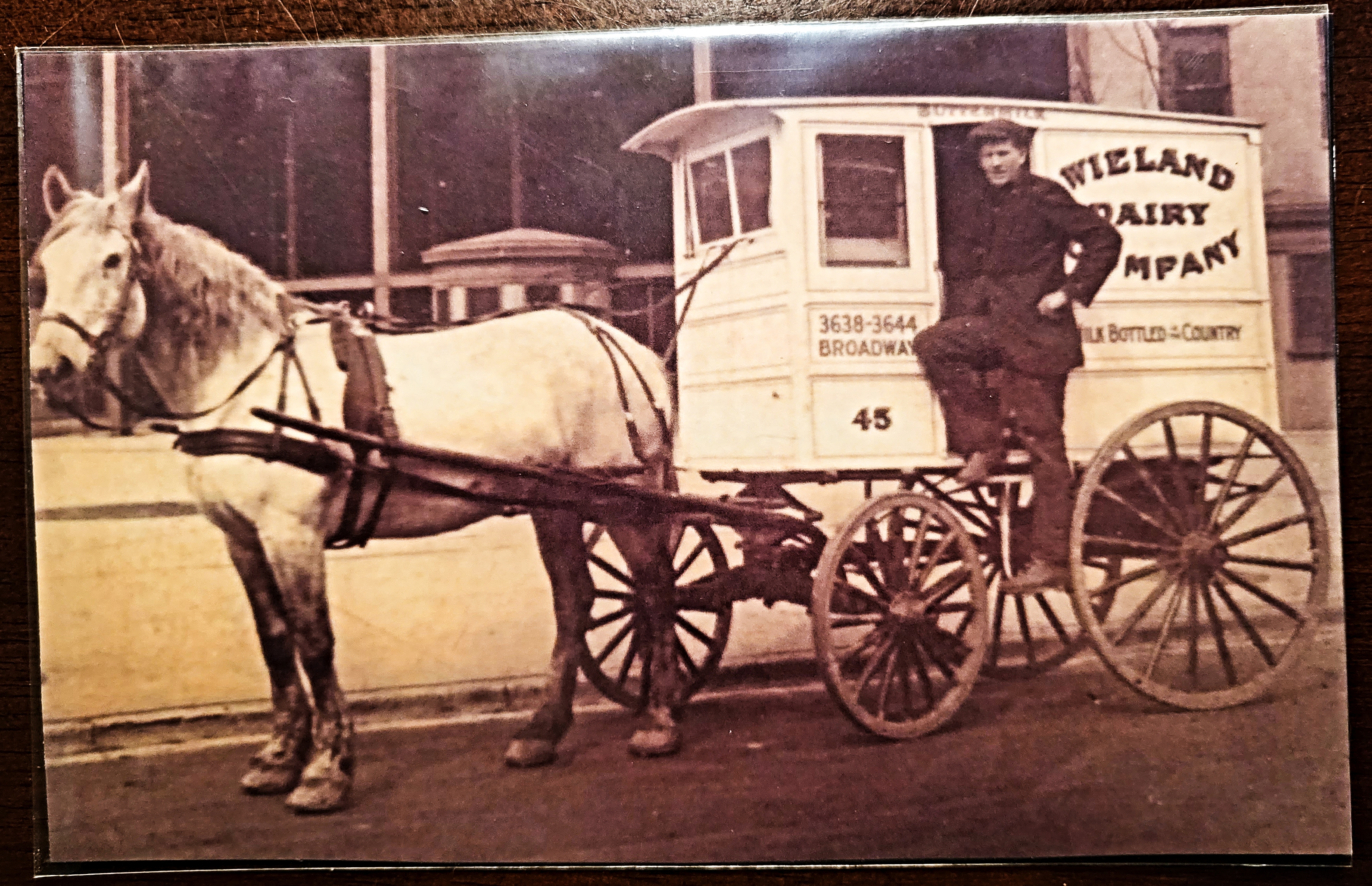


.jpg)


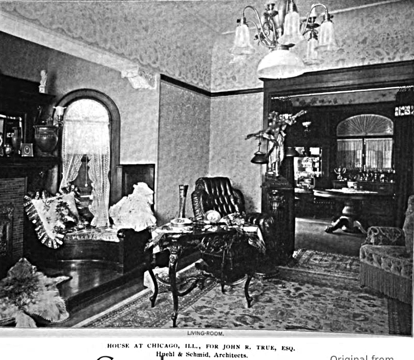


.jpg)

.jpg)
.jpg)


.jpg)


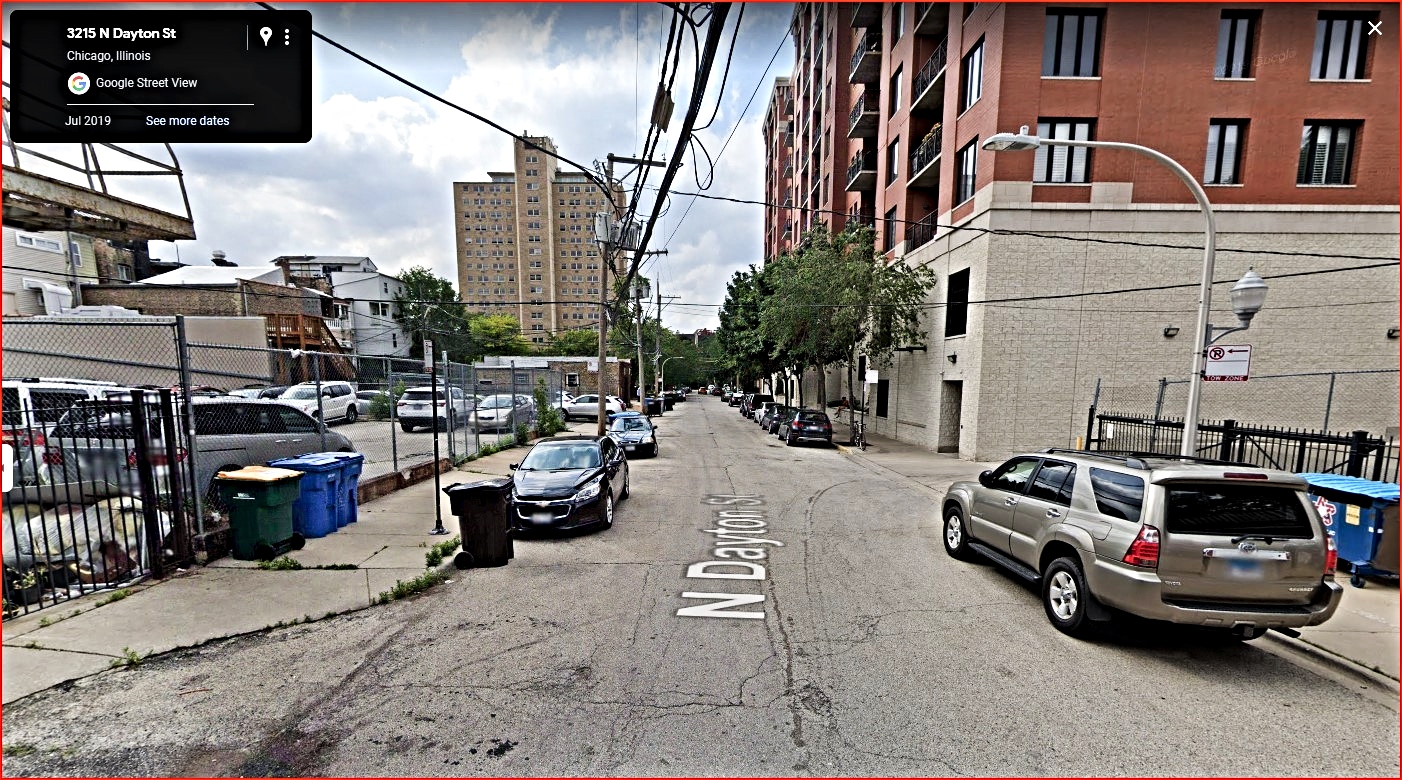


.jpg)
.jpg)


.jpg)
.jpg)


.jpg)
.jpg)
.jpg)
.jpg)


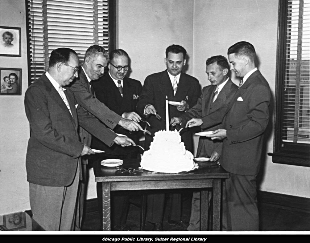


.jpg)


.png)


.jpg)


No comments:
Post a Comment
Email me at lvhistorical@gmail.com