This post covers several topics
The Horse-less Carriage Race of 1895,
Auto Dealerships,
Auto Garages that includes
Electric Car Garages,
Filling Stations, and finally
Cobblestone Alleys
of Old Lake View
1913 Chuckman Collection postcard
The Horse-less Carriage Race
Henry Ford arrived in Chicago in 1895 and managed to change the building landscape of Chicago with his first Chicago Ford dealership on South Michigan Avenue. According to a 2012 Chicago Tribune article by Jerome O’Connell, Mr. Ford picked a perfect spot to sell his 'horseless carriages'. He picked a location near the mansions and residences of wealthy and influential business folks of Chicago on Prairie Avenue a short distance away from Michigan Avenue. Other dealerships were built during the 1920’s along South Michigan Avenue. This strip of roadway would be later called
This would influence ....
map from a 1938 Chicago Tribune article
a zoomed view from above map
The apparent roads used in District of Lake View for the race were apparently Lake View Avenue, Sheridan Road, Belmont, Roscoe, Ashland, Cornelia, Pine Grove, and Grace Street.
image - Leslies Weekly Illustrated via Ebay
image - Automotive History
postcard below - Ebay
A Chicago Tribune article
published in 1975
the design of the winning media - Wikipedia
Prizes
images - Wikipedia
'The Smithsonian Institution states the following
regarding the winning Duryea car. "This car was unfortunately destroyed
through a workman's misunderstanding many years ago." The second-place car
of Hieronymus Mueller is on display in the Mueller Museum in Decatur, Illinois' per Wikipedia. - photo below
The Motor Row
on Broadway
By the 1910's the horseless carriage would be renamed the automobile and another area of the city would try to duplicate Michigan Avenue’s Motor Row but this time on N Broadway and other singular locations within the old District of Lake View but failed to receive any official local or national recognition apparenlty overshadowed by the south loop historical district's popularity and notoriety.Little Motor Row
on Broadway by 1920
.
This article link below mentions the second auto show at the Broadway Armory with participating dealers in 1921 before it became the 'Broadway Arena'
image - Chuckman Collection
in Lake View Areaimages - Warner Printing Company
H & G Motor Sales
3406 N Lincoln Avenue
Lake View
Motor Sales
2937 N Lincoln Avenue
a display 1926 ad
Packcard
Motor Car Company
once located inside the Hotel Belmont
1931 advertisements - Chicagoan
Shanesay Motor Company
2821-25 N Sheffield Avenue
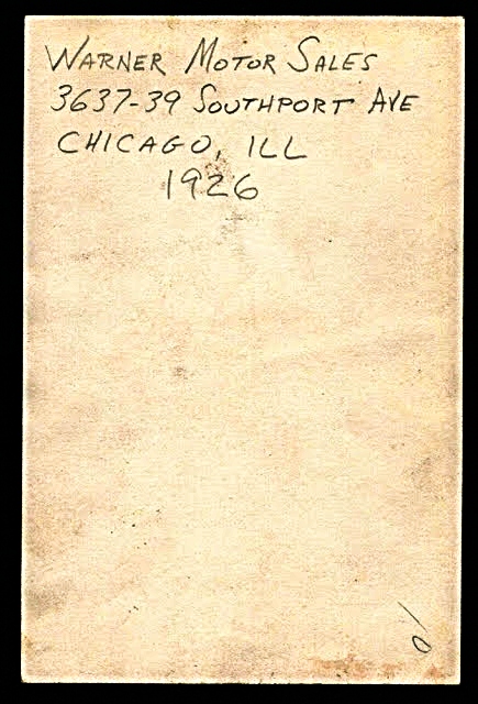
Warner Motor Sales
3637-39 N Southport Avenue
photo - Ebay
on Halsted/Clark in 1926
Other Dealerships in Lake View
H.G. Motor Sales Co
at 3406-08 Lincoln Avenue
Felz Motor Sales at 1132 W Diversey Parkway
Shaps Motors at 3737 N Broadway Avenue
Heinemann Motors at 1832 W Irving Park Road
While this motor row version was short lived in the north-side as a second ‘motor row district’, the concept of repair or parking garages did consume the building landscape mostly on Broadway Avenue and Clark Street with several others scattered on Lincoln Avenue, Southport, Belmont, Halsted, and other streets within the District of Lake View from 1917 to 1927 - for the purpose of this post. I will focus mostly on dealerships and garages along Broadway Avenue.
I picked this decade of years due to the several articles that provided me with dealership and garages listings from the Chicago Tribune Archives via the Chicago Public Library. According to my research Broadway Avenue, for example, was the location for 27 public, private and repair garages along with 9 dealerships from Diversey to Devon Avenue.
1934 advertisements - Chicagoan Magazine
To reside near a dealership or a garage in the early years must have been seen as a badge of honor not only due to this new type of transportation ownership but the necessity of having repair garage near your residence; attached private garages existing for the afluent. It was interesting to me to find a number of the garages still located at the same address or a garage and dealership that was transformed to another business establishment.
For example, former Treasure Island on Broadway was converted Cornelia Garage while the park building next to the grocery store was called the Stratford Garage. The Stratford Garage was listed as 'private' while the others were for general public use.
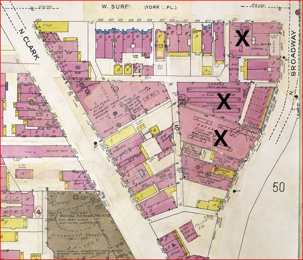
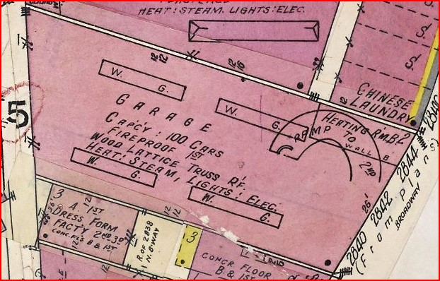
Below is a 1923 Sanborn Fire Insurance Map that indicates the location of the Cornelia and Stratford Garages now part of an apartment complex. As of 2023 no remains exist of what was.
News in 1905
Shenandoah Auto Livery
Company
photo - Bears Program/Ebay
1923 Sanborn Fire Insurance Map
of the location
north of Addison Street on Halsted Street
A Chrysler Showroom
814 W Diversey Parkway
(across the street in Lincoln Park)
pre 1936 photos - Chicago History Museum
2014 photo belowThe Lake View Garages:
The Cornelia Avenue and
Stratford Place garages
1923 Sanborn Fire Insurance map
zoomed view of both garagesconverted garages as of 1960'sexisting parking garage existing garage and
converted garage (front demo'ed) into Treasue Island
 the new look from Cornelia Avenue
the new look from Hawthorne Place
the existing garage has been replaced by hotel annexknow called 'Best Western Plus Hawthorne Terrace Hotel' Gerber Collision & Glass on Halsted
The below 1894 Sanborn Fire Insurance Map
shows a sizable Livery Service
at Halsted Street north of Roscoe
*pre-1909 address*
Sebastian Livery (1774 & 1776 N Halsted)
post 1909 address of3421 & 3423 Halsted Street (added addition) The Brompton Garage
3532 N Halsted StreetGoogle Map Views
pre 2011
renovation 2014 above 2016 below
X marks the spot
1950 Sanborn Fire Insurance Map
2019 Google Map photos
zoomed below
corner of Waveland & Halsted
south of above photo
across the street
Whole Foods
north of Whole Foods
Center on Halsted
A Garage on Lincoln/Ashland 3144-48 N Ashland Avenue
pages from 1922- Ebay
The Isaacson Garage
and Motor Sales
The Evolution of this Location
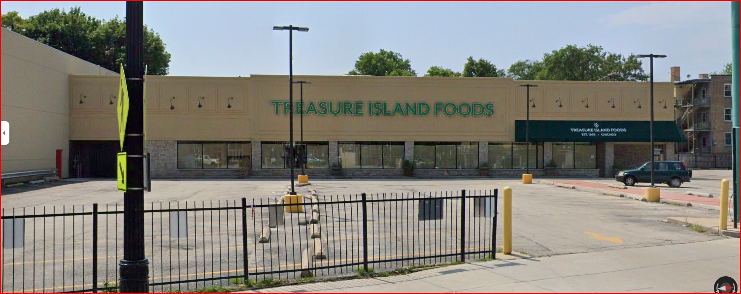
3020 N Broadway
once located within the once called
Bachelor Apartments
photo - TrolleyDodger via Uptown Update
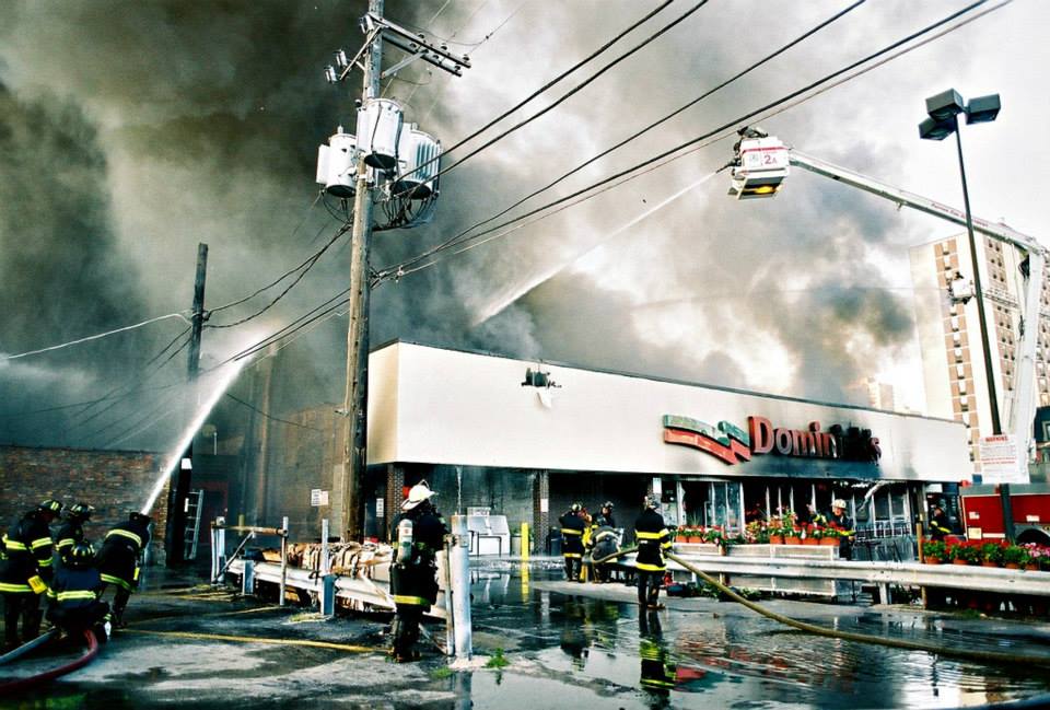
currently the location of Marino's and before that Dominick's
image - Ebay via Uptown Update 1950 Sanborn Fire Insurance Map
with shops ast sidewalk leveleasier to view belowAnd once the location for Dominick's
photo - Eric Herot via Flick
photo - Eric Herot via Flick
photo - CBS Chicago
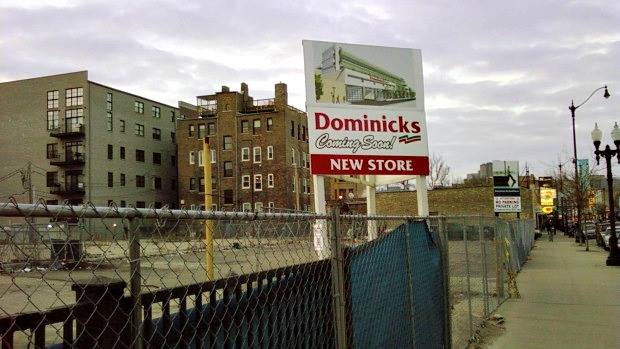
and nearly a year later ...
Now the space for
Mariano's
44th ward ofc photo
2016 photos - garry albrecht
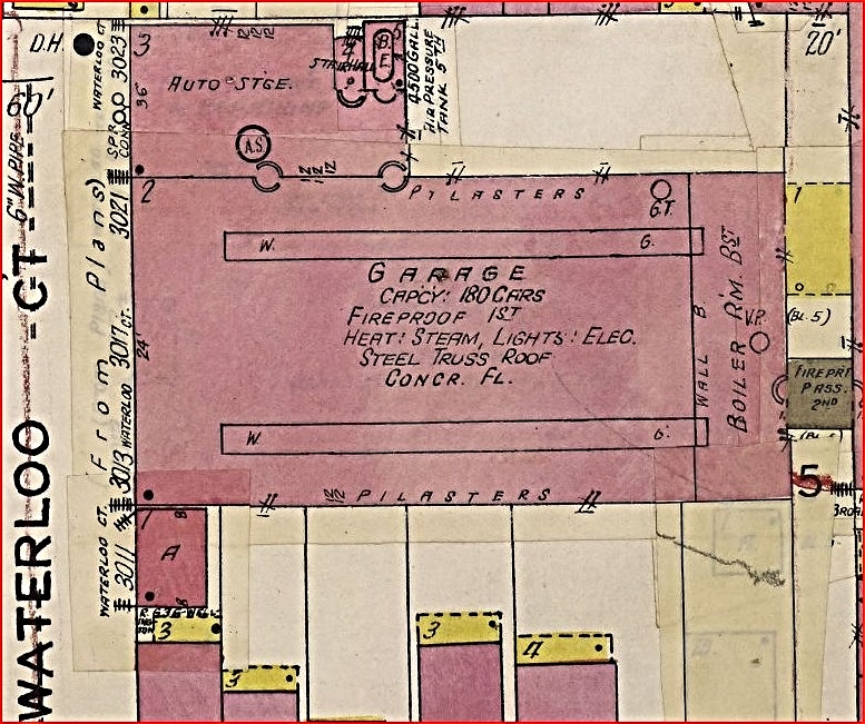
Once a garage now a park
on Waterloo Court
one block west of Broadway
1950 Sanborn Fire Insurance Map
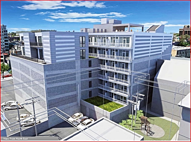
this park space masks the loading dock area of Marino's3115 N Broadway from a deco-style garage
to deco-style residencial
1950 Sanborn Fire Insurance Map
pre renovation to its renovation 2023 

“A building on Broadway in Lake View is undergoing an
unusual transition, only part of which pedestrians can see from street level.
The layer of drab exterior material has been removed from 3115 N. Broadway and
some handsome, old Art Deco features have emerged.
“But behind that rediscovered 1928 façade, there is a far
more intriguing transition going on. Built almost a century ago as a six-story
parking garage, the building is being turned into a 72-unit apartment building.
“John Mengel said his Northfield firm, JSM Venture,
bought the six-story parking garage in 2016 with plans to take off everything
but the lowest two floors and build new floors of apartments on that platform.
“‘Nobody wanted to try to take the whole thing down,
because this is lot line to lot line, with [neighboring] walls attached,’ he
said.
“The existing structure would only support so much
weight, so the new building could not be a lot taller than the existing
building. Ultimately, it made more sense to keep the garage and make it
apartments.
“The back portion of each floor is sloped because of the
ramp cars would drive up to get to the next floor. Meanwhile, the front portion
is flat, as that was where cars parked. The ramps are staying, and they will
allow renters in the building to drive up to the floor they live on, where the
flat portion includes both parking spaces and the new apartments.
“This is something that may not have been done anywhere
else in Chicago before. Mengel, whose son Charlie is his partner in the firm,
has restored other vintage buildings, including an old factory at 2850 N.
Pulaski Road and 3636 N. Broadway, the latter of which used to be the home of
Curtiss Candy, maker of the Butterfinger and Babe Ruth candy bars and later the
Recycled Greetings card company. In both of those, the Mengels’ firm put rental
storage facilities.' photos above - 44th ward office history presentation
From a Garage
to a Paint Store
3311 N Halsted Street
1950 Sanborn Fire Insurance Map
not sure this is what remains of the garage or not
and the
Building Next Door
a car wash/garage at 2823-25 N Halsted Street
... and a dealership by 1934
Broadway &
1950 Sanborn Fire Insurance Map
zoomed belowAll these garages were long gone before 'The Broadway at Surf' complex was built by the mid 1990's A List of Garages
on Broadway
Lake View Garage
Surf Service Garage
Roman Garage
Cornelia Garage
Stratford Private Garage Company
Lester & Stern Company
Delux Garage
The Electric Car Garages
by 1916
via Ron Tamulis/Facebook
District of Lake View
from the listed above
Garages that Supplied
Standard Oil Products
Lake View's
(Gas) Stations

Early on, according to Wikipedia, these places along the
road were known to motorists as ‘filling stations’. The first drive-in filling station was built by ‘Gulf Refining Company’
and then opened to the motoring public in Pittsburgh on December 1, 1913. (Prior
to this, automobile drivers pulled into almost any general or hardware store,
or even blacksmith shops in order to fill up their tanks). On its first day,
the station sold 30 gallons of gasoline at 27 cents per gallon. This was also
the first architect-designed station and the first to distribute free road
maps. Chicago based Rand McNally
would be the first to introduce road maps in 1904 but in New York City. The Filling Stations:
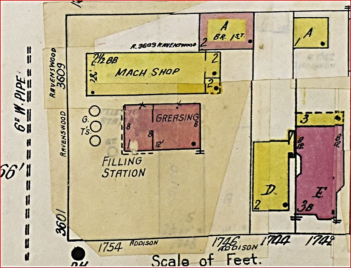
Steve's Gulf
Service Station
on Addison/Ravenswood
1950's photos - Robert Krueger Collection
via Explore Chicago Collection
Below is a 1950 Sanborn Fire Map indicates the station house was divided between the 'greasing area' and the 'filing station' with three gas pumps. The pumps faced East Ravenswood Avenue. According to this map illustration their was a machine shop on the property.
zoomed below
Most filling stations are still built in a similar
manner, with most of the fueling installation underground, pump machines in the
forecourt and a point of service inside a building. Single or multiple fuel
tanks are usually deployed underground. Local regulations and environmental
concerns may require a different method, with some stations storing their fuel
in container tanks, entrenched surface tanks or unprotected fuel tanks deployed
on the surface. Fuel is usually offloaded from a tanker truck into the tanks
through a separate valve, located on the filling station's perimeter. Fuel from
the tanks travels to the dispenser pumps through underground pipes. For every
fuel tank, direct access must be available at all times. Most tanks can be
accessed through a service canal directly from the forecourt.
image - Michael Smucker via Pinterest
Older stations tend to use a separate pipe for every kind
of available fuel and for every dispenser. Newer stations may employ a single
pipe for every dispenser. This pipe houses a number of smaller pipes for the
individual fuel types. Fuel tanks, dispenser and nozzles used to fill car tanks
employ vapor recovery systems, which prevents releases of vapor into the
atmosphere with a system of pipes. The exhausts are placed as high as possible.
A vapor recovery system may be employed at the exhaust pipe. This system
collects the vapors, liquefies them and releases them back into the lowest
grade fuel tank available.
The Gulf Oil Filing Station
on Clark
owned by the then Gulf Refining Company
Same 1935 photo from Addison view towards Clark Street with an insert of the filing station at the top left
photo - Brad Cornelius via Forgotten Chicago-Facebook
1950 Sanborn Fire Insurance Map
zoomed view of the Gulf Filing Station another station north of Gulf Station only the office section remains
view from Patterson Avenue
three photos - Roadside Architecture


The Design
The forecourt (pump island location) is the part of a
filling station where vehicles refueled. Fuel dispensers are placed on
concrete plinths, as a precautionary measure. Additional elements may be
employed, including metal barriers. The area around the fuel dispensers must
have a drainage system. Since fuel sometimes spills on the ground, as little of
it as possible should penetrate the soil. Any liquids present on the forecourt
will flow into a channel drain before it enters a petrol interceptor which is
designed to capture any hydrocarbon pollutants and filter these from rainwater
which may then proceed to a foul sewer, storm-water drain or to ground. Wikipedia edited
A Filing Station
on Roscoe
1950 Sanborn Fire Insurance Map
unknown name of station
zoomed below
2009 Google Map view
zoomed view of the original station garages2015 Google Map viewzoomed view of open space - garages are goneThe Filling Gas Stationon the Clark & Sheffield
southwest corner
photo above - part of my collection 1950 Sanborn Fire Insurance Map
Google Map location views
vs 20172019 Google Map view below
The K&S Garage
District of Lake View
zoomed view by CK Postcards
sold Portage Tires
zoomed from above
2019 Google view
now part of a condo building
An Unknown
Filling Station on Clark Street
This space as of 2023 is used for Wrigley Field parking
view from Clifton Avenue
When a Roadway
image above -1894 Sanborn Fire Map
Notice the existing shoreline
and then
image below -1923 Sanborn Fire Map
The avenue by name disappears from the landscape
alley 1 joins with alley 2
below is a 2016 Google Map
view of the now alley - former street
(Gormont Avenue)
a road or is it an alley?
This roadway existed in 1894 but not marked on the Sanborn Fire Insurance Map. By 1923 the road was called Gormont Avenue and by 1950 it was called Lakewood Avenue. Google Maps has the roadway still listed as Lakewood Avenue as of 2018.
1894 map
1923 map
zoomed from above1950 map zoomed from above
2018 Google mapzoomed from above
a Google photo view of the road/alleyway entrance from Irving Park Roadheading southand beyond the gateon to a side wark leading to a parking lot Brick Alleys:
those remaining and re-discovered
The story to this photo
This narrative is from Forgotten Chicago-Facebook
"I (Jeremy Huyser) is a heavy equipment operator, and we dig trenches all over the city. 99% of the trenches I dig are in city streets.
Usually we come across the old Belgian block pavers and trolley tracks which
the city just paved over. Last month, digging on Lincoln [Avenue] between Cornelia and
Addison, we unearthed untouched sections of Lincoln’s old wooden block surface.
It’s covered in about 8 inches of asphalt and was totally intact until I had to
dig through it."
Some Background
‘Chicago’s alleys were not always paved with asphalt, or
even brick cobbles. In fact, in the late 19th and early 20th centuries, efforts
to find economical materials led to Chicago’s streets being paved with wood.
Paving with wood blocks was developed in the mid-19th century by a Boston
builder, and by 1871 more than 50 miles of Chicago streets were paved with the
material. It was a reasonable solution to the muddy streets that preceded it.
Naturally, when the Great Fire hit in 1871, many of Chicago’s streets where
among the things that burned. While no wood block streets exist in Chicago today,
several wood block alleys remain and provide a valuable glimpse into the past.
Why it's no longer used
Brock Friedman, a commented from Forgotten Chicago-Facebook, brought up a very good point. “Most historic wood blocks with grade
contact/burial are saturated with coal-tar creosote. This stuff is "HORRIBLY
TOXIC. PLEASE DO NOT PULL IT OUT OF DUMPSTERS AND PLEASE DO NO TAKE IT HOME.
PLEASE DO NOT, DO NOT DO NOT STICK IT IN A MITER SAW AND TRY TO CUT IT UP. It
is a powerful skin, eye and lung irritant that will cause burns, cornea damage,
lung damage, etc." I do a lot of woodworking and when I inquired about
cutting some timbers I could get for cheap, the reactions were very alarming.
When you use power tools the saw dust is aerosolize and it is highly photo
reactive. So even with long sleeves, gloves and a mask you get burns all over
exposed skin. And God help you if you burn the stuff. And never, ever use it
around vegetables.
Yes, it's historic. But it's toxic. So. beware!”
Cedar Blocks in
Old Lake View 1886
image - Town[ship] of Lake View 1886 Annual Report
2018 Google Map edit
red x's brick/black x's concrete or asphalt
I decided to document in 2019 in what I believe the last
network on brick alleys within a local area of Lake View. I snipped photos of
this network of alleys before it’s forever lost and forgotten; paved by asphalt
or concrete. Most of the photos I placed in a Facebook album called 'The Catacomb of Brick Alleys' on my Facebook page. This section of this post was inspired by
visitors to my Facebook page. This was the most tedious documentation to date -
virtual mapping on Google Maps (Google maps very few alleys), snipping out
sections & then editing/enhancing using a editing tool called Pic Monkey. I
began my virtual journey at Belmont east of Racine & then continued to
Wolfram with some diversions here and there east toward Seminary Avenue.
Belmont east of Racine
the journey south to Wolfram

selective photos of the journey

 alley at Barry
 alley at George
below is the end of the journey view north from Wolfram
alley at George
below is the end of the journey view north from Wolfram
School Street to Roscoe
not all are brick

2018 Google Maps
2018 Google Map edit
2018 Google Earth view below
The Wooden Alley
at Roscoe Street
yards west of Lake Shore Drive
on the south-side of the block
an photo artist view below
by Tim M Hickernell
photos - Lisa Binkowski via Forgotten Chicago-Facebook

Hermitage & Lincoln Avenues
unearthed wood blocks
in 2021
photo - Jeremy Huyser
and what it actually looks like unearthed
photo below - Redmond Tunney McGrath
No Post Note
Follow me to my next Post called
Important Note:
These posts are exclusively used for educational
purposes. I do not wish to gain monetary profit from this blog nor should
anyone else without permission for the original source - thanks!


.jpg)
.jpg)


.jpg)


 Gerber Collision & Glass on Halsted


.jpg)

.jpg)


.jpg)


 photos above - 44th ward office history presentation


.jpg)


No comments:
Post a Comment
Email me at lvhistorical@gmail.com