Changing the Face
of Lake View
This post is about land & real estate and significant planned developments since the 19th century.
The post is divided into
The Land
& then
Vintage Real Estate
& then finally
More Recent Real Estate Developments
The 'Halsted Flats' development on Halsted Street near Grace that was once the location of Bismarck Gardens
THE LAND:
as the population expands so does development
1830-2030
before westward expansion27 years before the formation
of Lake View Township
the landscape transformed
11 years after the annexation of the City of Lake View
by the City of Chicago
the suburban explosion
... 20 years after the creation of official city neighborhoods
region under pressure
growth with a new planned developmental concepts and below
(interactive map)
northside
Lake View AreaBelmont Harbor Area 'Chicago's present natural geography is a result of the
large glaciers of the Ice Age, namely the Wisconsinan Glaciation that carved
out the modern basin of Lake Michigan (which formed from the glacier's
meltwater). The city of Chicago itself sits on the Chicago Plain, a flat plain
that was once the bottom of ancestral Lake Chicago. This plain has very little
topographical relief; in fact, topographical relief is so unusual in the plain
that what would be unnoticed hills and ridges in other locales have been given
names. The highest natural point within the city limits is in the Beverly
neighborhood at 41°42′12.5″N 87°40′37″W at 672 ft (205 m). In pioneer days,
this hill was called Blue Island, so named because at a distance it looked like
an island set in a trackless prairie sea. In fact, it and the nearby Stony
Island were both islands in Lake Chicago as it receded. On the North side, the
diagonals Clark Street and Ridge Boulevard run along ridges that were once
sandbars in the lake.' - Wikipedia
Type of Housing in Chicago
via Chicago Cityscape
written by Della Hansmann
This type of dwelling design is a staple of our neighborhood. This design consists of stacked apartment units with matching plans the Greystone multi-flat unit is easy to construction and replicate. Small variations in the facade make each unit seem unique but the same building methods could be used over and over again – much to the builder’s convenience. Further, by stacking several units, and placing the access door behind a shared porch, the multi-flat units were hard to distinguish from a larger single-family home. A street of two and three story Greystones give an impressive sense of density, cohesiveness and even grandeur that a street of smaller individual cottages or larger apartment blocks don’t have.
A standard bearer in the north-side particularly in our neighborhood this type of dwelling-form ensures that, regardless of who owned or built on the adjacent properties, this assembly of units will always have a little patch of green space in their tiny interior court. What’s more they all have access (both to airflow and view and for physical exits) to both the interior court side of the building and the exterior with its tiny porch/fire stair exits. Read more about this design form from Moss Designs from the above link that include great illustrations! Read more from Moss Designs - above link that include great illustrations!
Four Plus One apartments are often described as exploiting a loophole in the zoning code. Its more accurate to say that they were simply a residential building type which was allowed by the Chicago code … until it was actively dis-allowed in 1971 a city council measure requiring that all developers provide one parking spot per dwelling unit in zones R4 and higher.The original code allowed for residential buildings no higher than four floors to be constructed with masonry exterior walls and wood interior framing in Zones R-5 and above. Read more from Moss Designs
- above link that include great illustrations!
Although this classification is about the downtown area then our neighborhood we do have a structure on Waveland Avenue that can called a 'scaper'. It's called The New York.
Read more from Moss Designs from the above link that include great illustrations!
The Great Chicago Fire of 1871 barely touched the old Township of Lake View. Several factors played into the fact; one was the weather but also the sparseness of buildings north of Fullerton Avenue –the northern border with Chicago. These tiny buildings were built as short-term shelter solutions immediately after the fire, these modest homes originally featured pretty much just … exterior walls and a roof. More than five thousand were built in one month to house families without homes through that first winter of 1871. Due to the size of the structure and township building codes at the time (wood dwellings were still allowed) these types of buildings may not been the dwelling of choice by the township residents. Read more about this type of building design from Moss Designs from the above link that include great illustrations!
While mostly located in other locations then in Lake View bungalows are regarded as modest single family homes, with full basement, first floor and slant-ceilinged attic above. They are caped by low pitched roof with overhanging eves and entered through a front door off to one side, next to a wide bay of living room windows. The Chicago bungalow is brick faced, with decorative stone trim and wooden (sometimes leaded glass) windows. Read more from Moss Designs from the above link
that includes great illustrations!
by Curious City - WBEZ
'The 1920 census shows the street lined with two-flats [were] occupied by second generation Czech, German, and Polish immigrants in their 40's and 50's, raising Chicago-born teenagers. [They] included butchers, policemen, bookkeepers, bricklayers and librarians.' - read more from above link
'Annexation ended for two reasons: the city was growing too large and unwieldy to manage, and it hit a wall of suburban resistance. We courted Oak Park and Evanston, but, with well-established identities as railroad suburbs, they turned us down. The Metropolitan Water Reclamation District allowed suburbs to buy water from Chicago, and neighboring towns developed their own city services, often better than Chicago’s. Then, in the white flight era following World War II, suburban addresses became a class symbol. Chicago doesn’t have the motivation to grow either. The city makes more money selling its water to suburbs than to its own residents. Struggling suburbs such as Riverdale and Dolton might benefit from joining Chicago, because their property tax rates are so much higher but absorbing another municipality could be a strain on the city’s budget.' - Chicago Magazine
Daniel Burnham is best known for his admonition to “make no little plans.” He studied the great cities of the world and developed an approach to urban planning that was distinctive in being comprehensive, systematic and regional. Language from the 1909 Plan provides principles that continue to guide planning and development in the Chicago region today or does it?? images - The Chicago Plan
'In 1837, he was elected
the first mayor of Chicago, serving a single one-year term. From 1840 through
1841, he served on the Chicago Common Council as an alderman from the 6th Ward.
From 1847 through 1848, he served as an alderman from the 9th Ward. Ogden was a
booster of Chicago both during and after his tenures in elected office. At the
time he came to Chicago, its buildings were largely wood cabins, it lacked
sidewalks and decent bridges, it had no paved roads, and it lacked water supply
infrastructure. As a politician he advocated for the city to raise tax revenue
for new roads, plank sidewalks, and bridges (which he presented designs of his
own for). He also used his own wealth to fund improvements to the city's
infrastructure.' - Wikipedia
He, also, owned land in the Township of Lake View according to this 1870 Van Vechten map (X's marks the spots). According to this map he owned over 700 arces from Irving Park Road to Diversey Parkway, Western Avenue to apparently Southport (guessing about Southport) - not a road at this time. Some of his properties were co-owned. One piece was owned around Andersonville & Rose Hill areas (view sectional below). As a side note, the Chicago 's north border was just North Avenue when Ogden was mayor. North Avenue was given in 1837
as the north boundary of city until 1862 when territory went as far north as Fullerton and
the southern boundary of the Ciy of Lake View, former township was annexed.

zoomed view below
The mayor also co-owned (Miller) 76 arces of property in Andersonville to Rose Hill area
along the Metra tracks
another view of the sectional above
Sheridan Road/Evanston Avenue (Broadway)
at Montrose (Sulzer Road)
view south from Montrose
unknown date
VINTAGE
REAL ESTATE:
when land meets building
The Estates
of Lake View Township
by Everett Chamberlin 1874
This is a large township
extending north from the [Chicago] city limits a distance of over 5 miles and
from the lake shore west from two to three miles. The south boundary is but two
and a half miles from Clark street bridge. Its natural features are among the
best in the vicinity of Chicago. The wooded section in the southern edge of
which Lincoln park is situated extends along the lake shore far to the north
and many miles beyond the northern limits of Lake View. This gives the place
the very desirable advantage of grove lots throughout its length and breadth
and affords many very pretty residence sites which have been largely taken
advantage of by citizens of Chicago whose means enabled them to enclose large
lots and build handsome homes upon them. The place is thickly settled as a
consequence of these advantages and its nearness to business centers in Chicago
The area of the township is about ten square miles. The lands in Lake View
attracted early attention. The settlement dates back over a period of twenty
years and many of the lots having during this long stretch of years been
subjected to constant improvement the place bears something of the appearance
of the older suburbs about the cities in the East. Viewed from the observatory
of the new United States Marine [Federal/Veteran] Hospital the whole village resembles a
beautiful park. [Founded in 1857 and finally] incorporated in 1865 is in the
hands of a Board of Trustees [in accordance to Illinois law].
Property along the lake shore within a mile of the park [Lincoln
Park] is worth $100 per foot. North of the park values range from $75 to $45 per foot
according to its distance from the city [of Chicago]. The principal owners are Messrs. B.F. Culver, W.K. Nixon, Maj. Goodwin, S.B. Chase, J.H. Rees, J.V. Le Moyne, Hubbard
Boyden, J.B. Walker, H.G. Spafford, F. Tyler, and others. A majority of these
owners are holding surplus land for certain increase [investment].
- Chicago and It's Suburbs by Everett Chamberlin
The Land
Early Owners:
by Chicago and It's Suburbs by Everett Chamberlin
Daniel Goodman
Major Daniel Goodwin owns near the Marine [Federal]
Hospital [approximity between Montrose & Irving Park Road along the lakefront] a
beautiful home of 6 acres of tastefully ornamented grounds surrounding it. He
purchased the grounds in 1871 for $30,000.
and BF Culver


Mr. B F Culver has done at least as much as any other
party for the development of the town. He first purchased a tract of ten acres
in 1866 paying $600 for it and ten [more] acres in the following year paying $1,500
per acre. These two pieces of property lie between Wellington Street, Barry Avenue, the Evanston 'dummy' Road [Broadway], and Lake View Avenue and sell now at $125 per
front foot. In 1868 he bought property in Baker's subdivision at $20 per foot
which has increased to $100 per foot. The property known as Culver's Lake Front
Addition was bought in 1870 at $6,000 per acre. It now sells at $100 per foot.
Mr. Culver built the beautiful Italian villa and later sold it to Hon. Frank W Palmer. Mr. Culver has spent much of his time [with his] expended large
sums of money for the benefit of the locality and deserves the prominent
mention given above. This is located on Barry Avenue and was erected at an
expense of $24,000. It is full two stories and attic story in height of a very
handsome design both outside and in. The main entrance on the south side of the
dwelling is massive and ornamented with a handsome lower at the west side of it
which extends above the roof and culminates in a large & tastefully finished
observatory. The bay features seen at the west end are among the most attractive
arrangements about this building & afford a view to the north/south & west
of the elaborately adorned and extensive grounds about. The interior of the
house is finished in hard woods & arranged with symmetry & taste.
W.C. Goudy

Mr W.C. Goudy was instrumental in the creation of Lincoln Park, the park.
and was a Lincoln Park Board Commissioner from 1886-1893 representing the interests of Lake View
The residence of Mr. Goudy was on Wrightwood [Avenue] fronting on
Green Bay Road, an extension of Clark Street just north of Fullerton avenue, to the
limit of the city [of Chicago]. The house was erected in 1865 at an expense of more than
$20,000 and the ground with the present improvement is now worth $50,000. It
stands on a beautiful ridge so that the basement story is above the surface of the ground in the rear and the main entrance is only two or three steps above
it in front. The style of architecture is exhibited by the engraving. The grounds
are ornamented with shrubbery, flowers and fountains and covered with native trees. The front proper is upon Green Bay Road but opposite is a front with a
large veranda overlooking Lincoln Park [the park itself] and Lake Michigan furnishing an
unobstructed and magnificent view from every window. There is no place combining
better the advantages of city and country[side] than this spot.
Mr. J.B. Waller owns 53 acres of improved property worth. The house is a very large one of a very substantial build and looks like the fine old mansions to be seen in long settled districts. The reader can judge of the liberal outlay needed to build such a house and adorn the grounds about it by a glance. The cupola commands a view of Lake Michigan and a large radius of country around [at or near the St. Mary of the Lake Church]. The material of the house is brick. The interior is elaborately finished in hardwood and its fine apartments are spacious pleasant and comfortable. The cost of the structure was about $75,000.
J.A. Huck
The spacious grounds surrounding Mr. Huck's house compare
favorably with the best planned of those before mentioned. They
front 500 feet on Fullerton Avenue and extend south on Clark Street 600 feet. Although the outside of the house is of plain and simple architecture there are
few dwellings more comfortably arranged inside. The first floor is devoted to
parlors, dining room, family sleeping apartments, and kitchen The second floor
contains a large chamber parlor and several sleeping rooms with all modern
appliances and improvements. The site is valued at $225,000. Mr. Huck owns also a
fine tract of twenty acres adjoining Ravenswood in Lake View [Township] and has sown it
to grass, a preparation for subdivision, and sale in lots and blocks next spring.
1887 Rascher's Atlas Map - X marks the spot
Chicago Public Library online - edited
and bio via Library of Congress
The Spafford's cottage home was located on a triangular lot
containing five acres in one of the most attractive spots in Lake View [Township]. 1868 Vechten Map
1887 Sanborn Fire Insurance Map
zoomed from above
The lot
is bounded by Evanston [Avenue] (Broadway) on the west Halsted Street (now Clarendon Avenue), Graceland Avenue (Irving Park Road) on the south. Just across Halsted Street is the site of the U.S. Marine [federal] Hospital and on the south were the [gardens] grounds owned by S.H. Kerfoot. So that on the south and east an extensive and beautiful lawn
prospect stretches instead of a view blocked by rows of buildings. Mr. Spafford
has improved his home site in a very artistic manner with a large outlay. His
homestead is worth $7500.
2025 Google Map view
photo - The Life of [Senator] Stephen Arnold Douglas
(a close Chicago area friend)
below is his park along the lakefront
Kerfoot's Park along the Lake
text - 'Constructing Chicago'
Some Forgotten Houses
of Old Lake View
from a pdf called 'Daniel O'Hill Preliminary Summary'
Mapping Property Values
Lake View Township was founded in 1857 until 1887 when the City of Lake View from 1887-1889 was annexed to Chicago.
some of the original land owners
Check out this 1870 Van Vechten map of Cook County (zoom) and discover who owned tracts of property back then. Some names will be recognizable like the first mayor of the City of Chicago W.B. Ogden. Mr. Ogden's property values - about $1.25 - $2 bucks per square mile. Another early landowner according to a publication called Lake View Saga was George Snow when his lands were an mentioned as unincorporated area of Cook County.
The Park, Lincoln Park Adds Value
by 1872
Cemeteries in the township were not very popular by 1871. They were regarded as 'speculative' to the value of individual properties in the township according to this article below.
Land values from 1868 to 1872 of the township
between Belmont and Fullerton Avenues along the lakefront tripled from 1868 to 1872 particularly along Wellington and Barry Avenues selling $125 per sq. mile.
map - University of Chicago Library

Real Estate in 1882
1892 map
Three years after the City of Lake View was
annexed with the City of Chicago
1902 article
froma American Eagle
1928 map
Property values of the area that would that was
once called Lake View Township/City
A Growth Timeline
The years as a Township, City, District, and then
Community of Lake View 1857-1933
The Gross Park Area
of Lake View in 1887
Advertisement from
Gross Point on Henderson-Facebook
images below
'Lake View' by Matthew Nickerson
advertisement 1887-89
when Lake View was a city in Illinois
Properties
as of 1882
Prices of the Flat (apt)
in 1891
Three years earlier the City of Lake View
and 3 townships were annexed.
The Elevated was planned effecting private property
Two Decades Later ...
The 1920's were boom years for old Lake View
per this 1927 Chicago Tribune article
Rent Control Ends
in 1953
Edward Kelly was mayor from 1933-1947 Land Use for
Public Housing
'The federal public housing program started as part of the Housing Act of 1937, passed during the New Deal. First intended to be a jobs program and slums-clearing effort, public housing was the result of powerful grassroots organizing. Social justice advocates like Catherine Bauer of the Regional Planning Association of America mobilized massive public support for the movement for government-sponsored housing, i.e., public housing.'
This map & table reflect public housing
during the periods between 1935 and 1946
A New Concept
in Urban Planning by 1942:
Planned Developments
This 1942 map and legend reflect areas created by city administrators who believed in 'planned development' by pin pointing selected areas of future development.
Planned development is a means of 'land regulation' which promotes large scale, unified land development by means of mid-range, realistic programs in chase of physically curable, social and economic deficiencies in land use. Where appropriate, this planned development should control and promote the following:
1) A mixture of both land uses and dwelling types with at least one of the land uses being regional in nature.
2) The clustering of residential land uses providing public and common open space.
3) Increased administrative discretion to a local professional planning staff while setting aside present land use regulations and rigid plat approval processes.
4) The enhancement of the bargaining process between the developer and government municipalities which in turn strengthens the municipality’s site plan review and control over development for potentially increased profits due to land efficiency, multiple land uses, and increased residential densities.Vacant Dwellings
and Mortgage Risk Areas
a 1934 map and table
According to my research during the Great Depression years the northwest section of Diversey Parkway and Sheridan Road was occupied by homeless folks who lived in paper tar shacks.
1938 Depression Era
Mortgage Risk
I'm assuming A is better then B?
Vacant Land
as of 1945
(click on map to enlarge)
Housing Plans
as of 1945
(click on map to enlarge)
The Growth of Subdivisions
'The creation of a subdivision was often the first step toward the creation of a new incorporated township or town. Contemporary notions of subdivisions rely on the Lot and Block Survey System, which became widely used in the 19th century as a means of addressing the expansion of cities from surrounding farmland. While this method of property identification was useful for purposes of conveyancing, it did not address the overall impacts of expansion and the need for a comprehensive approach to planning communities. This kind of survey system starts with a large tract of land. Then the large parcel is broken up into smaller lots. After this, a map of these tracts is created. Each one of the tracts is given a number or letter. The land is then drawn out on paper and archived by a civil servant. From that point on, this map of the lot is legal.'
Land Occupied
by Dwellings
1857 to 1933
.jpg)
(disregard the harbor drawings until after 1916 & 1932)
 1844 - 1860Lake View Township were established in 1857.
1863-1879
The shaded area nearest the lake was
called the Pine Grove
1880-1929
The City of Lake View was annexed by the City of Chicago in 1889 as well many other township west and
south. The City of Chicago doubled its' territory in 1889 and its' value as a
city.
Paying the
Tax Man
This March 1889 letter was issued when Lake View was a city.
photos - Ebay
Property Values are still Assessed under the Township Name
and an unpopular form of taxation even back in 1895
a sample 1895 tax bill
for Lake View Township residents - Ebay
sent to a resident on 1753 Robey (3200 block of Fremont) from an assessors office at 622 (2701) Lincoln Avenue
A Sample Research
William Knoke
Property

Exterior view of 2937 N. Clark Street with a pre-1909 address of 1490 N Clark. William Knoke was a partner in a grist mill business - grain that is grounded to make flour, He owned rental properties in Lake View according to Ravenswood- Lake View Community Collection/Chicago Public Library. With additional research I discovered by 1903 he lived at (1690) 634 Wellington near his original home along Clark Street  by 1903 he moved ....

1891 Rascher's Atlas Map above
1894 Sanborn Fire Insurance Map below
The Lehmann Family
Properties:
One of the wealthest holders of land and property in the township/city and district of Lake View was the LJ Lehmann Family in the late 19th and early 20th centuries.The Lehmann Famiy and their trust owned land from Oakdale to Diversey - possible as south of Wrightwood, from the existing lakefront to Sheridan Road. The descendants of EJ would own mansions along the then called Sheridan Road (inner LSD) in the early 20th century.
Here are a set of articles along with some photos
that stress this point.
The articles begin with the ownship and the wealth leveged from it by the ownership of a department store called The Fair once located on State Street in the 19th & 20th century.
The Wealth
1891 Sanborn Fire Insurance Map
of his family home
District of Lake View
*Lake View was annexed in 1889*
According to the article above EJ Lehmann resided at the pre1909 address of 1326 Clark Street in 1900
(& for a few decades before)
zoomed below
accross the street & just south on Clark
from the Limits Barn
Visit my post called Northside Transport on the Limits Car-Barn
zoomed further below to expose the address
He owned a subdivision
at Clark & Addison
1891 Rascher's Atlas Map
(his name is located between Clark & the tracks)
Upon the Death
of his Wife
Augusta Lehmann
1908 photo - The Examiner
her home
on the southwest corner of Diversey & Sheridan Road
view from Sheridan Road northwest
1910 photo - Chicago History Museum
The Lehmann's
Planned Developments:
in 1897
*Apparently, the building was never built*
A Planned Development
in 1911
*Apparently, the building was never built*
The Lehmann Properties
in 1911
sells property that was bought in 1917
by her husband who bought it in 1901
The buidings are currently called
Commodore & Green Brier
postcard - part of my collection
The Lessing & Annex Apartments
The Lessing Apartments were/are across Surf Street
currently called the
Commodore & Green Brier Apartments
Augusta Lehmann Property
sold in 1922
for a Planned Development
in the area in 1928 but never happened
*Apparently, the building was never built*
Lehmann's demand change in
zonning in 1927
The Homeless Incampment
in 1931
a 1936 view of the area
photo -IDOT
The Contract
of 1904 due to change
(see related article above)
Lehmann Estate's
last Chunk of Property Sold
*to be St. Joesph's Hospital*
with a interesting note to add
St Joe's in 1959
Chicago Daily Tribune
More on the former
Lessing & Lessing Annex
Apartments
7.05 acres
the apartment buildings
by 1923
The F.D. Stout
Residence
1826 Wellington
post 1909 address of
534 W Wellington Avenue
brochure below - Art Institute of Chicago
apparently sold in by 1894 and demo'ed in the 1960's
and in 1971 replaced by a 4+1 building
1894 Sanborn Fire Insurance Map of its locationa conversion page of the addressabove the X
1830 Wellingtonpost 1909 address of
528 W Wellington Avenue
a 1962 illustration - Art Institute of Chicago
It Never Happened!!
545 W Barry Avenue
planned in the year of the Great Depression
some 'planned developments' fail
1950 Sanborn Fire Insurance Map
the 1950 map is a revision of the 1923 map
(From Plans) was pasted over
apartment building with garage in back
On the corner of Barry & Broadway was a no-name hotel in 1923 and then
became flats (apartments) in 1950
zoomed from above1950 mapzoomed from abovethe corner as of 2019 - Google Map
Plannned Develoments:
Sheridan Road/Briar Place
in 1914
 Sheridan Road/Roscoe
 in 1919

another view of it ...
According to Susan Reibman Groff this building was featured by the Art Institute in its 1989-90 calendar.
Described by architect Peter J. Weber as “the building which solves the servant
problem” because it provided rooms and baths on the first floor for chauffeurs
and butlers. Additional quarters for “help” were in a roof-story added at the
west end of the building. The French Neo-Classical façade is Bedford stone. The
north carriage entrance on the right has a
porte-cochère/a porch where vehicles stop to discharge passengers.
3314 &
3330 Sheridan Road
in 1918
views of 3330 Sheridan Road below
photos - Jim Martin
 interior view below
views from the harbor below
interior view below
views from the harbor below
 pre-1920 view above
 1918-19 below photo per Jim Martin
'In 1913, Hallberg brought his son into partnership. Like his father, Lawrence Gustav Hallberg,
Jr. (1887-1971) had been academically trained—he received a degree in
architecture from Cornell University. The two practiced together for only two
years before Hallberg, Sr., passed away. Following in his father’s footsteps,
Hallberg, Jr., created a number of significant local buildings. A Beaux Arts
style luxury apartment building at 3314 N. Lake Shore Drive is among them.' - Julia Bachrach Consulting
3520-3524 Sheridan Road
in 1923
image - Art Institute of Chicago
A Bief in 1923
1933 Ad - Chicagoan
Sheridan Road/Aldine Avenue
in 1926

(Patterson Avenue)
in 1925
3800 Sheridan Road
Sheridan/Grace Apartments
in 1926

1933 ad - Chicagoan
3750
N Sheridan Road
The 637-41 Aldine Avenue
in 1929
The 507 Aldine
advertisement - The Chicagoan
The 424-30 Briar Place
in 1926

3240 Sheridan Road
in 1926 
ad below - The Chicagoan
Apartments
and it evolution
1911-1965
Mayor 'Big Bill' Thompson lived here!
once at northwest corner of Belmont & inner Lake Shore Drive
photo - Forgotten Chicago Summary
text - Uncle Mame The Life Of Patrick Dennis by Eric Myers
The Property's beginning
along the existing lakefront
This residence was owned by Samuel Chase
who co-owned a company that saved the property deeds
out of the Chicago Fire of 1871.
After the fire his family moved here 1875.
1887 Rascher's Atlas X marks the spot
before Sheridan Road & N Lake Shore Drive
1894 Sanborn Fire Insurance Map
Sheridan Road would be constructed soon after
Lake View Avenue would be renamed from Diversey northward
zoomed view below
home replaced by
The Lochby Court Apartments the name was keep for location purposes
1923 Sanborn Fire Insurance Map
and then its replacement in 1962
by Harbor House
a renovated condo in 2018
photos - VHT Studios
photos - Curbed Chicago
(originally 1847 Wellington)
George Rounsavell Residence
image - Art Institute of Chicago
339 W Wellington Avenue
Mrs. Montgomery Ward Residence
built in 1915alternations in 1925 all images - Art Institute of Chicago
426 Surf StreetThe Broadway-Halsted
Building
located just south of Grace on Broadway
The Barry Apartments
by 1925
3100 N Sheridan Road
1925 full page ad - Ebay
The 433-37 Briar Place
in 1926


page 2


The 424 Melrose Co-op
in 1926

Financing for
422-25 Melrose

425 W Roscoe Street
built in 1927
photo - Chuckman Collection
with some current views of the interior
by Apartment People

Melrose/Sheridan Co-op
in 1927
at the northwest corner
of Inner LSD & Melrose
Intersection of inner Lake Shore Drive & Melrose Avenue in 1932
with auto heading to the Outer Drive
One year earlier the inner Drive was called Sheridan Road from Belmont Avenue to just north of Grace Street
The Eddystone
521 W Melrose Street
a Zillow 2020 photo view
the Mega Building
that Wasn't
image below - Forgotten Chicago
text below Chicago History Museum
'The Eddystone is located at 521 West Melrose Street in Lake View,
with its location highlighted in pink above and below. Designed by Holabird
& Roche as the first section of what was also known as the Sheridan Towers
cooperative apartment project, The Eddystone had the unfortunate opening date
of October 1929, the same month as the great stock market crash. The remainder
of Sheridan Towers / The Eddystone illustrated above would never be built. If
built it would have been the largest and tallest Chicago apartment building. An
examination of The Eddystone reveals it was indeed planned to be a part of a
much larger project, most notably its largely windowless walls facing prime
skyline and Lake Michigan views where the rest of this apartment building was planned
to connect to the Sheridan Towers project. Another building on the planned site
of Sheridan Towers would not be built until decades after the completion of
this odd and enduring relic of the Great Depression.'
below 1960's photo - Photographic Images of Change
University of Illinois at Chicago
pre 1936 photos - Chicago History Museum
3532-50 N Pine Grove
in 1938
 And then next to it
 in 1948 ...
The Meekerville Town Houses
in 1940
currently a historical district


in 1951
(view entire pamphlet)
(Lake Shore-Belmont Apartments)
in 1953

floor plan - Art Institute of Chicago
3950 Lake Shore Drive
in 1955
(Facebook album)
between Barry/Briar &
Sheridan Road & inner Lake Shore Drive
that was surrounded by a cement fence
A High-Rise Replaced the Enclosure
in 1962
3 1959 photos - Chicago History Museum The skyscraper rises 21 stories on a reinforced concrete
foundation. The Lake View development in on the north side of Oakdale Avenue at
the northern terminus of Commonwealth Avenue. It was built to house 57
residential units, with three on each level starting with the fourth floor; the
third floor also had four units. Each floor has full-height glass windows on
all sides. Floor slabs extend 3 feet (0.91 m) from the exterior walls on floors
3 through 21. However, the ledge over the main entrance is twice as long so
that the entryway is protected from ice. The lobby occupies the first two
stories. The penthouses on the top floor also have sunroofs. - Wikipedia
The building was one of the first completely air
conditioned all-glass apartments in Chicago. Stark in its repetition and
simplicity, it is a good example of the International Style. The building was
highlighted in a 1955 Architectural Forum article about recent Chicago
apartment buildings. - Wikipedia
3470 Lake Shore Drive
in 1967
28 story condo building
428 W Wellington Avenue
by 1960
2007 view - Google Maps
with a plan of the apartments in 1960

Hawthorne House
in 1965
3450 N Lake Shore Drive
For decades this property's only occupant were billboards.
but in 1965 and the last high-rise rental on inner LSD
A 1963 advertisement
The 336 W Wellington Building
in 1963

Pine Grove
Apartments
3639 Pine Grove Four Floors & basement-like Garage
by Living History of Illinois & Chicago-Facebook
and Forgotten Chicago
The simplest definition of a Four Plus One is a five story apartment building where the first floor consists of the lobby and a parking lot. It is often cited as a building type that is unique to Chicago. Most of these buildings were constructed during the 1960's to solve the problem of over-crowding due to urban renewal, particularly from the Lincoln Park area.
416 Barry Avenue The Barry Apartments
No More '4 Plus 1's'
Please!!!
The Plus & Minus of 4+1's in 1985Other 4+1 Samples:
1959 photos - University of Illinois/Chicago
Photographic Images of Change
540 W Melrose
455 W Wellington
in the 2010's
I resided in this building from 1993-2014. Reside Living bought the building in 2012 and completely rehabbed it. I enjoyed both experiences until I was priced out
1950 Sanborn Fire Insurance Map
X marks the spot where 4 plus 1's replaced single family dwellings. There were more. Below is a zoomed view. My building 525 did not exist in 1950. The southside of Stratford Place almost became a wall of brick completely transforming the individuality of the block.
of the Condo 1970's:
 3730-40 N Lake Shore Drive

 3150 & 3180 N Lake Shore Drive
the layout of 3150
floor plan 1 & floor plan 2
floor plans - Art Institute of Chicago "Can not build them
fast enough"


3440 Lake Shore Drive
445 W Wellington Avenue
image - 2016 Google Maps
Art Institute of Chicago 1951 floor plans
655 W Irving Park Road
photography by Chris Cullen 2018 a 1985 article about it
The New York
There were to be two buildings
photo - Chris Cullen 2018Plaza 32
3232 N Halsted Street
Once the Largest Concentration of Apartment-Hotels
in Old Lake View
from Broadway to Pine Grove
and from
Oakdale to Diversey Parkway
1923 Sanborn Fire Insurance Maps
a more details are in another post
The 1923 List
Oakdale Apartment-Hotel
Green Brier Apartment-Hotel
(former Lessing)
Commodore Apartment-Hotel
(former Lessing Annex)
Surf Apartment-Hotel
Pine Grove Apartment-Hotel
Cambridge Apartment-Hotel
also in the map above
Brewster Apartments
Hotel Rienza
21st Century
Planned Developments:
2014 Google Map viewphotos - Lakeview Patch
2017 photos - Curbed Chicago
3030 N Broadway
The local neighborhood area lost their grocery store in 2005 and waited all most a decade for a replacement.
The drama about this planned development
'Lake View Booster' 2012 article
It finally begins ...
Ground Breaking Ceremony 2015
photo - Tom Tunney (alderman) via his Facebook page
winter 2016 photo - Garry Albrecht
summer 2016 photo - Garry Albrechtsummer 2016 photo - Garry Albrecht
(a LakeView Historical Facebook album)
and before that per Sanborn Fire Insurance Map in 1950 there was an apartment building
zoomed view below - Bachelor Apartments as of 2013
of east & central Lake View
image - Lakota Group
The Clark Street Task Force Maps
'A task force seeking to revitalize the street hosted an
open house Wednesday night seeking feedback on how area residents, business
owners and property owners want to see Clark spruced up. People attending the
open house at Century Shopping Centre at 2828 N. Clark posted stickers on a
blown-up map of the area to indicate places that needed improvement. And a lot
of areas need help if the number of stickers is any indication. Red stickers
were placed on buildings that people thought needed beautification or façade
updates, and red peppered a good deal of the street. "The buildings are
just not that attractive," said Mary Beth Smith, a residential real estate
agent and local Chamber of Commerce volunteer.'
- from an DNAinfo article
the renditions ...
images - Lakota Group


updating while remembering the past ...
the photo below is of the intersection of Clark/Diversey
Revitalization of a
Old Plan
as of 2024
The Idea Boards
photos - 44th ward newsletter
the northwest corner of Clark & Barry
 via Curbed Chicago
via Sports Authority
Jemillex B via Foursquare

via Sports Authority
photo below - Chicago Real Estate Local
... the old vs the new look for the corner in 2017
via Curbed Chicago'A shuttered commercial block at the busy Clark and Halsted intersection in Lakeview is set to be refreshed and repurposed as a new medical facility. Advocate Medical Group and partner Advocate Illinois Masonic Medical Center have inked a lease with property owner Next Realty, LLC to transform the space at 3154 N. Clark Street into a new medical center spanning 42,000 square feet.'
3300 N Clark
The Lake View Learning Center
This educational facility was affiliated
with Truman College in Uptown
the original address location was 3010 N Clark Street
2018 photos - Garry Albrecht
the new look for the corner below
the TOD planned development 2018
images via Southport Corridor News and Events
the developer scaled downed for the initial plan
How tall should it be??
'Lakeview 3200'
on the northwest corner of Belmont/Clark
2013 photo - Lake View Patch
the first rendition above
2016 photo - Curbed Chicago
the second rendition
The site also lists apartments available for rent — and
they're anything but cheap. Available apartments range from a 431-square-foot studio
to a 1,452-square-foot two-bedroom apartment with two bathrooms. Rent starts at $1,525 for a 436-square-foot studio, or
$3.50 per square foot, according to the 'Lakeview 3200' website. Topping the list
is a two-bedroom apartment with two bathrooms that costs $3,800 per month, or
$2.62 per square foot. But the building does have great benefits, with a Target
downstairs and a two-minute walk to the Belmont Red Line station. On average, the building's 57 one-bedroom apartments will
run around $2,300 per month. From a 560-square-foot unit to some as large as
900 square feet, the one-bedroom units average 711 square feet.
the evolution of the corner in maps
1891 Rascher's Atlas
1894 Sanborn Fire Insurance Map
1923 Sanborn Fire Insurance Map
1950 Sanborn Fire Insurance Map above
photos - Building-Up Chicago
2016 photo - Garry Albrecht
2016 photo - Garry Albrecht

2016 photo - Garry Albrecht
age old battle between 'big box' stores & independents
and the buildings that were razed for it
photo - DNAinfo
for teenagers during the 80's and called reverently as Punkin Donuts
'Ingram describes the group at Punk'in Donuts as a family. He grew up with a single mom who struggled to make ends meet, and his friends at Clark and Belmont helped him navigate his teenage years. "I fit right in," he says. "We looked out for each other. If you were hungry, you were fed. If you needed a place to crash, it was provided. If you needed protection, so to speak, from outsiders that were giving you a hard time, you could find it there. It was a place where we were able to learn certain values that otherwise might not have presented themselves in such a way that we had support, social support, around us.' - Reader
photo - Lake View Patch
photo - DNAinfo
2013 Google Map view
hanging out in the actual alleyway was popular and the back door entrance the The Alley
photo - DNAinfo
photo - Max Forster via LakeView Historical-Facebook
 photo - DNAinfo
photo - Lake View Patch
photo above - Lake View Patch
the Dunkin Donuts location in 1950
photo above - Ebay
1990's photo - Andrea DiMaur Walton via Forgotten Chicago Discussion Group
photo below - DNAinfo
Saving the Past with Google Maps
Look for this blacken box within it is a clock that will expand when clicked. The clock space will highlight years from 2007

Since 2007 Google Maps have a done a great job of saving history with the use a a little known feature I call the 'corner clock'. This Google Map feature is located on the top left side of the computer screen. Click on it and the feature expands into a set of years typically from 2007. Google digitally and typically records the same location each year & sometimes twice a year. If you wish to save let's say an image from 2008 I use another feature called the 'snipping tool' from my computer. The user can find the snipping tool through your 'search' tool from the lower left of your computer. The snipping tool icon looks like a small blue scissors circled in a reddish orange. I save the icon on my tool bar on the bottom of my computer screen. Click on 'new' within the the snipping feature and the background screen will fade and a red border once click on screen allowing the user the cut any portion of the computer screen wanted. Below are the results of the use of both features of the intersection of Belmont and Clark.

July 2015
 September 2015

both images - September 2015
with the Alley on the right side of snipped screen
The Alley: One of the Victims 

a Mark Thomas (owner) business card
the second location
page - East Lake View by Matthew Nickersonphotos - Mark Thomas - ownerbelow 2005 photo of the actual alleyway - Wibiti.com
Mark Thomas-owner on the right
with a devoted employees
'The Alley' did not survive the construction phase
at this location - moved to Albany Park neighborhood
photos - Yelp
2016 photo - Garry Albrecht
This building was once a theater - see my post on Theaters Past.
Demo Photos by Martin Gonzalez


The New Look for the Building Space
2016 rendition - DNAinfo
2018 photo - Brian Weber via Original Chicago-Facebook
The Alley briefly reopened at 3223 N Clark
across the street of its former space
below photo - Mark Thomas
a former family style Italian restaurant
2016 photo - Chicago Cityscape
2016 transition photo - Google Mapwith a new look below
photos - DNAinfo
2016 image - Lake View East Chamber of Commerce
old commercial district area
1922 view on Ashland north
negative - Chicago History Museum
1994-2018
This retail space became the center of the redevelopment
above photo - Chicago Public Library 1985
below photo - DNAinfo 2013

the original stand-along building in 1907
The First Planned Development Version 2007
‘“People like to say it’s a walking city, but we all still have our cars,” admits Centrum Properties‘ Nick Stocking. Buyers at Lofts at Lakeview Collection, the project manager hopes, will be able to leave their cars parked underground and spend more time on their feet. “It will be very inviting for walking traffic in the neighborhood,” Stocking said of the development, located where Ashland, Lincoln and Belmont avenues intersect in the bustling Lake View neighborhood. The six-story building will have 131 loft-style condos on the top four floors and about 90,000 square feet of retail space on the first and second floors. “Obviously it’s an amenity to have the convenience of all the retail below you. We think that’s a big selling point,” said Stocking. Another draw of the development, Stocking said, is its green space. The developer is building an 8,000-square-foot public park at one end of the “sort of L-shaped” building and an 8,000-square-foot landscaped plaza on another. The plaza will have bushes and trees as well as café style seating for retailers. “It’s going to be really easy to just go downstairs in the elevator, walk outside and get a cup of coffee, hang out on the corner in the plaza and get some sun, and walk around,” Stocking said. “You just really feel connected. You don’t have to get in your car, basically — it’s right outside your front door.” Part of connecting Lake View Collection residents to the neighborhood meant connecting the mostly glass building to the older buildings, including Saint Luke Church, that surround it. Architect Hirsch Associates designed the northern corner composed of traditional brick that “harmonizes the building with the rest of the neighborhood,” said Stocking.’Future Plans for the Location in 2013
LAKEVIEW — The Belmont/Ashland/Lincoln corner may soon be home to Target. After months of speculation, the Minneapolis-based company has confirmed that they've closed a deal on a building at 3201 N. Ashland Ave., a location previously slated to be a condo building with 130 units. No details were available on a planned opening date, according to Target spokeswoman Erika Winkels, but another company spokeswoman said previously the company does not typically announce store openings more than a year in advance. "Chicago is a great market for Target and we continue to pursue new opportunities to serve guests there," Winkels said in a statement. Before the store can open, Target must present its proposal to West Lakeview Neighbors, the Lakeview Chamber of Commerce and the Community Directed Development Council, according to Bennett Lawson, chief of staff for Ald. Tom Tunney (44th). The proposal will likely need approval from the Chicago Plan Commission and the City Council Zoning Committee to amend the original plans for the building, Lawson said. - DNAinfo
Target Selling the Building 2014
LAKEVIEW — Target is trying to sell a former bank
building at Lincoln, Belmont and Ashland avenues that it bought in hopes of
building a store, the company said. The Minneapolis-based company bought the
building at 3201 N. Ashland Ave. last year with plans of opening a store there
— going as far as showing preliminary renderings to West Lakeview Neighbors
last May and announcing an October 2015 opening. The long-vacant building
previously was slated to be a condo building with 130 units. But Target
spokeswoman Erika Winkels said in an email Thursday that the retailer is
"actively marketing the property for sale." - DNAinfo
The Second Planned Development Version 2014

‘The old LaSalle Bank building at the northeast corner of
Belmont, Ashland and Lincoln avenue has changed hands, and its new owner, Novak
Construction Co., has announced plans to build a new development that would
focus around a large 60,000 square foot ground floor retail component with 80
to 160 residential units above it, Crain's is reporting. The property has sat
vacant for years, and a previous plan to build a mixed-use development stalled
out at the height of the real estate crash. Early last year, Target purchased
the property, with plans to build a new store at the location, but after
sitting on the property for a little over a year, the Minneapolis-based big box
retailer decided to dump it this summer.’ - Curbed Chicago
The Third Planned Development Version 2015

CHICAGO, Nov. 10, 2015 /PRNewswire/ - Located at the
highly-visible and historic triple intersection of Ashland-Belmont-Lincoln
Avenues on the city's North Side, America's Healthiest Grocery Store™ is set to
dig in to a new location.

Novak Construction Company, the project's Developer
and its General Contractor, is proud to announce the official groundbreaking
ceremony this Thursday at 9:00 a.m. at 3201 N. Ashland Avenue. Construction on
this Gensler-designed, ground-up 70,000 square foot store will start this
month, replacing the current Whole Foods Market location at 3300 N. Ashland
Avenue when complete. "Activating this long vacant lot, the site of the
former LaSalle Bank, was a priority for us once we acquired the property,"
says John Novak, Novak Construction's Founder/President. Reflecting on a time
when the neighborhood was known as a bustling shopping mecca for the city, he
added, "As the sole tenant, we know Whole Foods Market will not only
enhance the community and accommodate the needs of its residents, but also
usher in an era of new businesses and activity in this location. We would love
to see this project stimulate that kind of growth." The new store will feature a second-story balcony for
outdoor dining, additional indoor street-level dining along Ashland, and a
vibrant year-round green-wall adjacent to a park setting on Melrose. The new
Whole Foods Market location will bring improvements based on the current
store's challenges, most notably increased aisle space, additional grocery and
prepared food choices, and more parking. "Whole Foods Market has proudly served the Lakeview
community since 1996 and we're thrilled to bring our neighbors this new
store," says Michael Bashaw, Midwest Regional President, Whole Foods
Market. "This larger location will be filled with even more of the natural
and organic foods that our customers love along with lots of new amenities,
services and even a few surprises that we hope will delight our shoppers."
Groundbreaking Ceremony 2015


LAKEVIEW — It's West Lakeview's time to shine. That's the prediction Ald. Tom Tunney (44th) made
Thursday during a groundbreaking ceremony for the neighborhood's new Whole
Foods Market at 3201 N. Ashland Ave. Tunney said Lincoln, Ashland and Belmont "was once —
outside of Downtown — the busiest retail corridor" in Chicago. The city's
second-largest Whole Foods will kick start its revitalization, he said. "Stay tuned, folks in our neighborhood, because
there are a number of meetings about this intersection and how we're going to
enliven" it, Tunney promised. While it took months to get neighbors on board, both
Tunney and Novak Construction executive Michael Kanzler said the resulting
changes made for a stronger end product. "The process was kind of long and painful ...
looking back, it's the process that needed to happen, and it got us the best
results," Kanzler said. Over the ensuing eight months, a vocal group of
neighbors pushed for a more attractive street level facade and the addition of
a park on the Melrose Street side of the building. While concerns remained over
increased traffic, West Lake View Neighbors gave the development their
endorsement in a 50-19 vote, and digging on site began soon after. - DNAinfo
along with bank to be demolished was the
Medic Building just south of it
Darren Spinelli via Flickr 2012 Google Map Views
a 2016 view
vs a 2019 view
The Many Alterations
According to DNAinfo, 'Developers repeatedly returned to the drawing board over
the course of eight months and a dozen meetings, tweaking designs after getting
feedback from a vocal subset of the group, named 'Melrose Street Concerned
Residents'. MSCR very local organization at the time.
2009 vs 2017 Google views
2009 vs 2017
Whole Food closed their smaller space
at 3300 N Ashland Avenue and then became a Target
 photo - Pierre-Henri L. via Yelp 2013
photo - Pierre-Henri L. via Yelp 2013
photo - Willem B. via Yelp 2012

photo - Willem B. via Yelp 2012
Now, a Target
on the corner of Broadway/Clark/Diversey
above photo - Chicago Racked
2013 photo above - Chicago Real Estate
from a Central Savings to Borders
and then to a Walgreens
2012 photos above - Lake View Patch
'The River North-based firm Hirsch Associates LLC said on its Facebook page that the old Borders store at 2817 N. Clark St. in the East Lakeview neighborhood will be taken over by Walgreens for new, two-story “Wellness Experience” store with more space and features than a typical Walgreens drugstore. A rendering of the space shows a new, spacious front
entrance at the V-shaped intersection of Clark Street and Broadway. In the
current configuration, the old Borders store has entrances on both Clark and
Broadway, while the proposed new entry way area was occupied until recently by
the building’s other tenant, Central Savings and Loan. The Borders bookstore that used to occupy the site closed
in April after 16 years in business, along with all the other Borders stores in
the city except the flagship store at 150 N. State St. They were among 200
stores that closed across the country when after Borders filed for Chapter 11
bankruptcy protection. In July, Borders liquidated its remaining stores,
including the State Street store, and went out of business altogether. Racked points out that the East Lakeview Borders was by
far the city’s biggest, at 42,770 square feet, compared with only 32,000 square
feet at the State Street location. The three-story store featured books on the
first and second levels, and CDs and DVDs on the lower level, as well as a
Seattle’s Best coffee bar. Since the Borders store closed, its red sign has
continued to light up at night, but a look through the window reveals empty
shelves and holes in the wall where pipes once supplied water for the coffee
bar. The main level of the old Borders did briefly reopen in October as a
pop-up Halloween store.The Central Savings branch that had been in the building,
which predated the Borders store by many years, recently moved to a new
location a short distance to the north on Clark Street.' - CBS Chicago
at the pinnacle of Clark Broadway Diversey
2013 photo - Tom Tunney-Facebook
Ribbon Cutting Ceremony
2013 photo - Tom Tunney-Facebook
photos below - Yelp
seeking new tenent
in 2024
the occupants before that ...
Walgreen's former location was east of Broadway
with former Borders and Central Savings to the west
where Walgreens is now located
2009 photo above - 'Chicagoismyblog'
and before that ....
photo - Ravenswood-Lake View Community Collection
the Central Savings building
along with a view of Ace Hardware
that had an entrance both of Broadway
and Clark Street
and before that ...
and before that ...
photo via Kenneth Joesphson from
Forgotten Chicago-Facebook
Lincoln Plaza complex
East of Broadway on Diversey Parkway
old Walgreens still vacant as of 2021
2016 photo - Original Positions
decades before that it was in ...
The Curtiss (Candy) Building
on Broadway side of the building
where most of Lincoln Park Plaza is located today
image - Chicago History Museum
with the potential future of that corner
Since Walgreens decided to move to an existing and renovated space across the street this planned development has been on hold as of 2021
2014 planned development
at the former Walgreen's space
photos - Curbed Chicago
photos via 44th ward office - Tom Tunney alderman


boarded up in 2021
2021 photo - Richard Gray
the newer look in 2024
740 W Diversey Parkway
both occupants share the same extended building

the hole in the ground
was a public garage and garage for the Chicago Park District and apparent business on the corner
a 1950 Sanborn Fire Insurance Mapan area of garages
The façade was saved of the former Chicago Park District garage to became Whole Foods
The Center on Halsted takes shapeformer Chicago Park District garage

What is the Wagon/Wing
Symbol all about?
I found two definitions for it1) 'The wagon wheel is symbolic of transportation, successful journeys and expeditions, and also perpetuity. Winged wheels are symbols of peace, flight, freedom and spiritual transport. There are many charges that feature wings which have their own meaning; such as a winged globe as a symbol of the holy spirit. In Heraldry a single wing is called a “demi vol” and usually enjoys the symbolism of the eagle. Associated with Hermes, the great messenger of the gods in Greek mythology. The winged wheel is also a symbol of progress.' - 2) 'The logo is a synthesis of technology and biology. The wheel might represent technology or artificial power, and the wings might represent biology or natural power. Transhumanists look at humanity's historical relationship with technology and see a trend of persistently increasing inter-dependence and intimacy. Projecting that trend forward, we imagine the distinction between technology and biology fading away, as we integrate it ever more intricately into our world, relations, bodies, and minds. Some have suggested that sufficiently advanced technology may be indistinguishable from biology, and that the best technology is so transparent that we stop referring to it as "technology."' 
photo above - Center on Halsted
former garage & store fronts
1995 photo below - NewNowNext
3740 N Halsted Street
former location Bismarck/Marigold Gardens
*the beer garden outside space*
rental units on the west side of Halsted/Broadway
Construction Phase 2013
photos - Lake View Patch

The former site a German-American Beer Garden
The 'Chicago Out'
Hotel
A neighborhood association said NO!
and the alderman said NO!
to this planned development on Halsted in 2013
it was never developed
the developer's staff and community meet
with the Triangle Neighborhood Association at the
19th police district building
photos - Lake View Patch
The developer tried to side-step the association that had jurisdiction
on the development - Belmont Harbor Neighbors
the planned development stemmed from the vacant storefront that used to be Mark's Chop Suey
2009 photos - Google Map
its various design looks to win neighborhood association approval, as well as the alderman's
 First rendering of the Chicago Out Hotel
images - DNAinfo


End of an
Neighborhood Association
because of it

'LAKEVIEW — Money woes due to dwindling membership and
legal threats have led a more than 40-year-old Lakeview neighborhood
organization to dissolve. The volunteer board of Belmont Harbor Neighbors, a
non-profit formed in 1973, voted to dissolve the civic engagement group last
week after president Doug Ochab noted that the group's bank account, made of
membership fees, had largely been emptied. Ochab partially blamed legal fees linked to a
controversial vote on a proposed LGBT-hotel last summer for the money woes.
Other group members said the dissolution is about finances, period. "It became clear that BHN would not be able to pay
future expense[s]," Ochab said in an email. The attorney general still needs to approve the official
dissolving of the 501(c)3 organization. Rifts in the organization appeared to begin last summer,
when the BHN board clashed with Lakeview business owners and employees over
plans for the Out Hotel Chicago. The group ultimately rejected Parkview
Developers’ proposal to build an LGBT-focused boutique hotel at 3343 N. Halsted
St., and Ald. Tom Tunney (44th) followed suit. Robert Brumbaugh, owner of Progress Bar, 3359 N. Halsted
St., threatened to bring legal issues to the Illinois attorney general if Ochab
and his wife did not step down from the board, claiming the way they handled
the Out Hotel vote violated state non-profit laws. He said BHN only allowed those living near the proposed
hotel to vote, allegedly ignoring Lakeview business owners and employees who
thought the hotel would be good for the area. BHN's bylaws say people who work
or live in the neighborhood are eligible to vote. Brumbaugh also said his aim is to create a
better-functioning organization. "As long as the alderman's office [considers] votes
taken by the Belmont Harbor Neighbors association, everyone has a stake in that
it represents the community — and not just a handful of people," he said.
"It's not about the Out Hotel. It's about moving forward." BHN's fees came from hiring legal counsel to investigate
Brumbaugh's allegations. But to some board members, Brumbaugh was determined to
take down anybody who opposed the hotel project.' - DNAinfo
Once a 'Auto Laundry' Facility
and the 3 flat to the south
before the words 'car wash' during the turn of the 19th century car wash were called 'auto laundry'
- believe it not!
photo with enlargement
photo - Art Institute of Chicago via Explore Chicago 1934 ad below - The Chicagoan
the renditions below
Not be Saved as is
but engulfed
2821 N Halsted Street
photo - Zillow
Construction
Google Map photos
these two photos highlights
both buildings that the developer purhased2015 view below of the facade for the 3 flat that will engulf the buildingzoomed from photo above
2016 view below of the demo of the from car wash &garage2017 views below
building near the elevated
An Example of TOD's:
3400 N Lincoln Avenue
along the tracks
2014 photo - Curbed Chicago - Lake View
2014 rendition - Streets Blog Chicago
revised 2015 renderings below - Curbed Chicago
1418 Addison Street from single family to multi-rentals the evolution via Google 2007 view2016 side view2018 viewthe final result in 2019
506-514
Diversey Parkway
images via Lake View Patch named
'LAKEVIEW — Developers on Monday night announced plans to
create a 50-unit apartment building near Diversey Harbor in Lakeview. The Parkway East project at 506-514 W. Diversey Pkwy.
would include ground-floor retail, two stories of residential parking, 44
two-bedroom apartments and six three-bedroom penthouse suites. "These are rental units," developer Jeremy
Michor said Monday at a South East Lake View Neighbors meeting. "It will
be built on a higher-end finish." Two-bedroom apartments will be roughly 1,100 to 1,200
square feet, Michor said. Three-bedroom penthouses, which will take over the
building's top two floors, should average 3,200 square feet. Michor wouldn't speculate on rent prices, saying it would
depend on the market when his project launches. The building will offer 50 parking spaces — one for each unit.
Drivers can access parking-garage floors through an alley behind the building,
which would also be used for move-ins and garbage collection.' -DNAinfo

2016 rendition pdf via Tom Tunney alderman office
2017 photo below - John Keating Jr.
via Forgotten Chicago-Facebook
construction photos below
currently called
No. 508
Broadway/Sheridan Road
from a gas station to apartment high-rise
'East Lake View Neighbors reviewed and approved a new proposal for the former gas station located at the corner of N. Broadway & W. Sheridan (close to Gill Park) on February 9. This development is expected to cost over $20M. Next step is for this to go before the 46th Ward Zoning & Development Committee on February 29. If you do not know who your representative is on this committee, please call the 46th Ward Office. Your representative needs to hear from you."' - Uptown Update
the gas station that was once on the northeast corner
photo - Mark Zippererrenderings - DNAinfo
mid 2017 photo - Garry Albrecht photo - BuildingUpChicagoDotCom photos - BuildingUpChicagoDotComand then south across the street ...3817- 45 N Broadway
planned development 2015 photo - DNAinfophoto via Chicago Cityscape the liquor store was replaced by the development on Sheridan Roadphoto - geoview info replaced by the development on Broadway
photo - DNAinfo
the eagles were saved & reused as part of the new building
1987 photo - Equinox27 via Flickr

the terra cotta details - Chicago Designslinger  Betsy Rubin via Facebook 2013Angela Larson via Facebook 2014
 a view of it in 1937
photo - IDOT Collection
view east on Sheridan Road - bank on the right
The Terra Cotta Removal
 both photos from Mike Butland via Facebook 2016
 2016 photo - Carey Wintergreen
2017 Google Mapsthe removal of the terra cotta for storage 2017 Google Maps mid 2017 photo - Garry Albrecht
mid 2017 photo - Garry Albrecht
photo - BuildingUpChicagoDotComphotos - BuildingUpChicagoDotComThe terra cotta is back in 2019!!2019 photo - Chris Cullen Photography2019 photo below - Uptown Update 2021 photo below - Carey Wintergreen
photo - Chuckman Collection
the first rendition - Curbed Chicago
'After making the rounds a couple years ago, a Transit-Oriented Development (TOD) proposed just feet from the Lakeview’s Sheridan Red/Purple Line station is finally looking to move forward. According to a tip from a nearby resident, a legal notice regarding the project’s associated zoning change from B1-2 to B3-5 was recently distributed. Based on the flyer, Chicago-based Loukas Development is looking to build an eight-story building with 54 residential units, ground floor retail, and 11 parking spots at the northwest corner of Sheridan and Dakin. The project, which will replace a vintage three-story brick apartment building, has evolved considerably since 2014 when Loukas came the community with a modern, modular design with 60 dwelling units and 24 parking spaces.'
the second rendition below
This Transit-Oriented Development near the Sheridan Red Line Station will replace Hampton Apartments a more modern look below - Cragin Sping via Flickr
back to square zero but rehabbed
According to Uptown Historical Society the building will be saved and rehabbed in 2019. image - Uptown Historical Societybelow 2019 Googlee view Now on the
opposite corner
Sheridan Road
photos - DNAinfothe replacement


Braum Reality photos
ACE Hardware remains
and across
the street ...
still vacant as of 2022

Craftsman Plating & Tinning Company
1240 W Melrose Street
and 1225 W School Street
The property stretches from Melrose to School Street
2021 renditions

and what it replaced ... the latest rendition as of 2022
 photo - Chicago Cityscape
2019 Google Earth view
the truck entrance on Melrose - 2018 photos
vs the view from School Street
1624 W Wolfram Avenue
the vacant land
1950 Sanborn Fire Insurance Map view
of the area
zoomed view below
The Belmont 450
450 W Belmont Avenue
construction phase
before - the twin apartment buildings
A Hotel Evolution
on Diversey/Clark
postcard - Chicago History in Postcardsthe first name abvoe
the second name below

the third name ...  'The new name Hotel Versey pays tribute to its original namesake The Diversey Arms, while playfully fusing in a tie to the hotel’s
 V-shaped structure of its triangular city block, on the highly visible corner of Clark, Broadway, and Diversey Parkway [intersection]'
and on the opposite corner
in Lincoln Park
on the southeast corner of Clark & Diversey
2017 image - Chicago Tribune
in transition - via John P Keating
Forgotten Chicago-Facebook

2017 image - Chicago Tribune
vintage images of the same corner below:
J.J. Sedelmaier via Forgotten Chicago-Facebook
and from TrolleyDodger below

photos - via Curb Chicago Lake View
2016 photos - Garry Albrecht
Artis Senior
Living Lakeview
former space for
3535 N Ashland
Phase Plans
Bert Wiemand Ford Dealship
famous for their late night commercials in the 1970'sclosed in 2006
deconstruction photo below
 a demo view below - mysore.blogspot.com2009 view north from Addison2017 view north from Addison2019 Googles views945 W Belmont
hugging the tracks - a TOD
the before 2018 viewThe Wilton
3500 N Wilton Avenue
a restoration
2019 photos - 44th ward office
2021 Google Map views below
Howard Brown
Health Clinic


 The building it will replace ...
This building was once the home of one of the first gay bar on Halsted, Little Jim's. A separated building on Cornelia adjacent to the soon to be demolished building was home of Cornelia's Restaurant
- it had various names in the last 2 decades.
Sanborn Fire Insurance Map
zoomed view below2022 photos - Build Up Chicago 3 2023 photos below - Lakeview East Cooperative
on BroadwayGoogle Earth photo via 44th ward office
Treasure Island was once located at 3460 N Broadway. The entire grocery store chain closed in 2018. The store was established at this location in 1963 as their 'flagship' building.
2009 photo - Google Maps 2018 photos - Google MapsI had a problem with the year
image below - LakeView Historical
ad - Ron Tee via LakeView Histroical/Facebook
The area via a
1950 Sanborn Fire Insurance Map
The Public & Private Garages
listing - Chicago Daily Tribune 1921
the X's represents the newer TI building - a cut-out of the garage
a 1894 view of the corner
The first renditions of the property presented in July 2019
to community residents for approval


the parking garage south of the former Treasure Island once called the Cornelia Garage, & once owned by the owners of TI to be a hotel called
view north toward TI
view south from TI parking lot
view of the TI parking lot north
view north of the existing hotel
view south of the new TI development
back courtyard with older hotel on the right
835 W Addison Street
a mixed use building
old vs new
This is a proposal to turn the Lake View Lutheran Church, which has a smaller congregation than in the past, into a mixed use-church and disability accessible rental building. This development will serve residents at or below 30% of the area’s median income with accessibility needs, which is a hard to serve population. It is an opportunity to provide affordable and permanent supportive housing in this location.
The community room is for basically for congregants
Building - Up Chicago photos
views along Addison Street
the northeast corner of Southport/Belmont


2017 photo below Southport Corrridor News & Events
what was there before
3401-09 N Southport
with the latest 2018 rendition

images via Southport Corridor News & Events
what was there before
3150 N Southport
what was there before ...
2017 photo - Google Maps
what was there before
Herdegen Brieske
Funeral Home
aerial view of the areaaerial photo via DNAinfo1989 photos - Chicago Public Library
photo above - John Morris /Chicago Patterns
 photo - via Adam Rodriguez FC FB 2018delevopment included the space behind
 the funeral home
the renditions below
image - Curbed Chicago
photo below - Chris Cullen 2020

City Club
Apartments
3636 N Lake Shore Drive
There have been several renditions
referred to as New York II
 #2 in 2019 with a crown on top
#3 in 2020 minus the crownwith a slightly different look on the
lower building in 2021
UPDATE 2/2021: The developer is currently meeting with East Lake View Neighbors
to review this proposal.
UPDATE 4/2020: After many months, an agreement has been reached between the developer, City Club Apartments (CCA), and the New York Private Residences (3660 N. Lake Shore Drive) regarding ingress, egress and other traffic and use issues.- 46th ward news what was there before ...
1950 Sanborn Fire Insurance Map
3172
Clark Street
southeast corner of Clark & Belmont
*it was always a bank building*
2021 Google photos
along Belmont Avenue
along Clark view north Google view from Clark Street south of Belmont Avenue
parking lot and drive-through (entrance on Clark)
Broadway to the left & Belmont to the right
Demo Notice from Cityscape
detail photos by me
the entrance on the corner with a side view off Belmont below
photo above - Chicago Bars vis Twitter What the Corner will Look Like the first rendition
with a new address
Problems
with Occupancy Maybe??
Demolition in August 2021
photos - Eric Dudi Huebner
Closing off the Sidewalks
44th ward office
Some of the Former Occupants
of this Building:
these collectables from my collection
Lake View State Bank
the first one

Belmont National Bank
the second one
N Clark Street
from Clark to Dayton Avenue
renditions and blueprint below
once 3711, 3215 & 3717
per this 1950 Sanborn Fire Insurance Map
and
it's Ghost Signs
corner of Addison & Ravenswood Avenue
photos - Loop.net
view north above from Addison view east below from Ravenswood
The Replacement
Originally at this Corner
photos - Cali Digital CollectionsA Surprise:
Ghost Signs
The house behind the builiding of storefront on Ravenswood also will be demolished. During the deconstruction of the exterior siding multipyle ghost signs were discovered.
another view of the area
2021 Google
with enlarged photos by Bill Savage
from the article
An Update
the removal process
2022 photos by John Meyers
and saved
The Construction & Replacement
2025 photos - Chicago Yimby
Ashland Avenue
Renditions - Urbanize Chicago
with EV charging station hook-ups for cars
view southeast
view northeastAre All New Buildings
TOD's??
I thought TOD designated buildings were to be
adjunct to the elevated but I guess I'm wrong
Brownline to 3310-12 Lincoln AvenueBrownline to 1654 W School Street 1138 W Belmont
Avenue
photos below - Yelp
the rendering of the replacement building
from 44th ward office development page
1113-1115
W Patterson
 text - Redfin
the replacement
rendition - 44th ward ofc view from Pattersone Avenue
1894
pre 1909 addresses
on Briar Place
The Two Buildings to be Replaced
Redfin photo & text
and
453 W Briar Place
the 2 Flat
photo - Yimby & text - Redfin
an aerial view of the space
Replacement
Nov 2023


photo - YIMBYInitial details have been revealed for the mixed-use
development at 3327 N Lincoln Avenue. ThIs planned development is located just
south of the intersection with W Roscoe Street near the Paulina Brown Line
station, the project will replace four existing buildings including the former
home of beloved Dinkel’s Bakery. Developer PCR Group has submitted a
rezoning application for the Jonathan Splitt Architects designed structure. -YIMBY
2023 Google photos
map & rendering - Chicago Cityscape
Permits
in Janurary 2025
some facades remain
That Neon Sign
3150 N
Racine Building
"Alderman Waguespack worked closely with
Mercy Housing to
improve and expand the existing Single Room Occupancy (SRO) residential
building at 3150 N. Racine. The Alderman approved a zoning change in 2022
enabling the expansion of the building into the adjacent surface parking lot.
This plan will add 16 units, for a total number of 86 permanently affordable
units. Prior to the zoning approval, the Alderman arranged for a presentation
by the developer to South Lakeview Neighbors, who voted to approve the project.
After several attempts to secure financing, Mercy recently received a
Low-Income Housing Tax Credit (LIHTC) award from the City. The plans include a
complete interior renovation of the existing units. The scale and height of the
new building will be consistent with the context and character of the existing
structure and the balance of the block." - 32nd Ward Office
in Lake View
Affording housing in the City of Chicago has been an issue for several decades. In the 21st century SRO's have been converted to 'market-rate' housing or a small percent of any particular new development that can reserved for the poor or seniors. In my blog post called 'Hotels to B&B' I mention how several former apartment-hotels constructed during the early part of the 20th century were by the end of the 20th century in decay while at the same time milking rent from the residents-at-need with sub-standard living conditions.
photos - DNAinfo
Abbott Hotel on Belmont were one of those apartment-hotels that fell into decay and financial abuse. There were others like such the Chateau Hotel on Broadway
Affordable Housing Building in Lake View
as of 2019:
Crowder Place
photo - Chicago Cityscape
Mulvey Place
416 W Barry Avenue
photo - Apartment Home Living
The De-Converting Era
by 2017
According to Crain Chicago developers much like Golub Capital-middle market lenders have been scouting the Chicago market for opportunities to turn condo buildings back into rentals, reversing the condo conversion trend that dominated the city in the 1970's and 1980's. Back then, developers could buy entire apartment buildings and sell them for a profit individually as condos. “Big-time players are looking at prices and saying, 'I think we could buy this building lock, stock and barrel and make money by running it as an apartment building,'” says Chicago attorney David Sugar, a partner at Arnstein & Lehr- chairman of the firm's condo law group. “Hopefully, condo boards will figure out that they can make 50% more selling to these apartment idiots chasing a bubble,” says David Ruttenberg, principal at Marc Realty Residential, a Chicago-based apartment landlord. “Hopefully, I'm the fool they call.”
The Wave Lakeview
420 W Belmont Avenue
2016 Google Maps
According to a 2017 article by Curbed Chicago condo
de-conversations continuing to hold steady as the most lucrative sector of Chicago’s real estate market. The complicated process of “de-converting” of existing condominiums into freshly refurbished rental units is gaining popularity for first buy renters. One such project in the Lake View neighborhood is ready to start welcoming its first tenants. Situated at 420 W. Belmont, the 206-unit Wave Apartments occupy the 30-story 1967 tower that was once known as Bel Harbour Condominiums. The largest Chicago deconversion project to date.
image - Curbed Chicago
The Floor Plans for a studio & two bedrooms


photo - The Wave website
photo - The Wave website
photos - Yo Chicago
The Conversion to Condo's in 1966
Finally Happening
2024
The 925 Belmont
Development
from 909-921 Belmont Avenue
2024 photos - 44th ward office
The proposed project is an 11-story apartment building, comprising 210 residential units per Chicago Cityscape map view - Chicago Cityscape
2024
The Second Rendition
with one less floor
May 2024 The Shops/Stores Gone
Belmont Army Vintage
The Gallery Bookstore
bopNgrill
American Paper Store
Les Fleurs Du Mal
Ann Sather
will have a space in the new building
Scaled Down
2025
another view of it
The Eyesores
of 2024
3 are in Lake View Capt'n Nemo's was known for its nautical theme and
house-made soups, opened in 1992 as part of the mini-chain first launched in
Rogers Park. In 2019, the year Nemo's founder Lou Ragusi died, the Ashland
location closed due to the expense of complying with city codes, according to
Ragusi's son. - per article
Capt'n Nemo's was known for its nautical theme and
house-made soups, opened in 1992 as part of the mini-chain first launched in
Rogers Park. In 2019, the year Nemo's founder Lou Ragusi died, the Ashland
location closed due to the expense of complying with city codes, according to
Ragusi's son. - per article2021 Google Map views
Yelp Photos
Tequila El Milagro used to offer great tacos on fresh
tortillas before or after a show at nearby Schuba's. Then one day in 2007 it
shut down "temporarily" with a sign that said "closed for
renovation."
2021 Google Map views
Yelp Photos
Johnnie's Lounge was the dive bar throwback from
the building's style to the bar's jukebox.
2021 Google Map views
Yelp Photos
the owner
One Development,
Two Locations in 2024
3310 N Lincoln Avenue
&
1654 W School Street
3310 N Lincoln Avenue
2022 Googe view of current sitesWith a design from Johnathan Splitt Architects, the new
construction will encompass a six-story mixed-use building. Rising 80 feet, the
project will front N. Lincoln Ave with 2,227 square feet of retail space while
holding 24 units on the upper floors. Split into 8 one-beds and 16 two-beds,
approximate rents will run $1,900/month and $2,400/month respectively. Five of
the apartments will be designated as affordable units. While the rezoning
application is limited to the site at 3310 N. Lincoln, materials from the
developers show a plan for a complementary building at the corner of W. School
St and N. Paulina Ave. Addressed as 1654 W. School, the building will stand
five floors and hold another 23 residential units. - per Ubanize Chicago
Yoshi's Restaurant
Replacement
3257 N Halsted Street
as of 2024
to be constructed in two years-ish
In 1982, Chef Yoshi along with his wife Nobuko, found a restaurant space that they could call their own. It was located at Aldine Street (now known as “Yoshi Katsumura Way”) and Halsted Street in the Lake View. Yoshi’s Café, a small 48-seat dining room, had arrived in 1982. The proposed project is a six-story boutique hotel
focused on serving the LGBTQ+ community, including a first-floor restaurant and
a basement speakeasy. The developers are local to Chicago, and the Heart of
Lake View Neighbors (HLVN) Neighborhood Association has voted to support the
project. We are still soliciting feedback from residents. - 44th ward newsletter
the replacement
A 51-room six-story hotel has been proposed for this
space, with a rooftop pool and bar and a retractable roof, ground-floor
restaurant, and basement bar. It will
have unique amenities, be locally owned (no chain), and in keeping with our
unique neighborhood. It will increase
day-time foot traffic on Halsted, and there’s no good lodging alternatives
now. They will hire about 60
people. They are asking for a zoning
variance to make this economically feasible.
They are making efforts to obtain parking access next door and across
the street, as well as at Belmont and Halsted.
Most patrons will be walking, using rideshare, or on public transit according to 'Heart of Lake View' Nieghborhood Association minutes.
the buildings old design vs the new design
hotel elevation
3625 N Halsted Street
featured by
Bye Bye to a
business & its' water gavity tank
2021 Google views
owned by Phoenix Electric Manufacturing
manufacturer of brush holders
painted blue by 2016

Google views
view from Addison
view from Halsted view from Waveland
below - Office Illinois State Fire Marshal
707-709 W Briar Place
pre 1909 address
1653-54 Briar Place
2024
text above & photo below - Redfin1894 Sanborn Fire Insurance Map
Some interior views
from Redfin & Zillow
The Sand Pit
in 2024
featured by Building-Up Chicago
a conversion from 2 lots to one
Apparently, sand was used as a fountain or it was always there??
X marks the spots
Sanborn Fire Insurance Maps
1894
pre-1909 address of 881
labeled as a dwelling or house
post 1909 address of 3034 & 3036/3038
labeled as a storefront
same addresses
labeled as a dwelling or house againDemo photos Newest 'Pot' Location
Planned
3650 N Clark Street
green area - entrance
the development does not include the former Gulf Oil Station
3 photos - Roadside Architecturethe planned development is to
replace this building north of the Gulf Oil Station with entrance on Clark Street
The entire station until 2011
photo - Google Maps
The entire station in 1950Sanborn Fire Insurance Map
zoomed from above
the other dispensaries
as of 2025
2814-16 N Halsted Street
The proposal preserves the
existing first-floor commercial façade and adds three stories of residential
space, resulting in a 57-foot-tall structure with 12 two-bedroom/two-bathroom
units. The first floor will maintain three commercial spaces, while the rear
will feature six parking spaces and bike racks for residents, both enclosed
within a security fence. Additional amenities include a rooftop gym and roof
deck with a dog run. - 44th ward development page
Post Notes:
Once it Was There
and Now it's Not:
Sanborn Fire Insurance & Google Maps
How many times have you walked by a particular location and noticed a new building or vacant lot and wondered what was there before.
Sanborn Fire Maps are the Google Earth views of today. The Sanborn's were like a time machine of the past of former structures within a given area illustrated not by computers but by human hand on sheets of paper. It and was a necessity for city departments like Fire and Sewer departments as well as private insurance companies. The sheets below have been zoomed & edited for this section. The map sheet used in this example is from sheet #84 from volume 9. Volume 9 is a Lake View area label. These maps have a wealth of information for researchers & historians like me. 1894 1923 above vs 1950 belowGoogle Maps/Earth
The Google Maps (2007- present) is great historical tool on the changes to a particular area of interest for real estate research and documentation. The viewer can be located if you
float the cursor over the top left area of the Google map. Within the black rectangular
area on the top left of your screen is a small clock icon that will expand into a timeline.
in Lake View
since 2009
Planned Developments
most of Lake View is in the 44th as of 2020
the northeastern section is in the 46th
west & north is the 47th
and a southwestern section is in the 32nd
32nd Ward
*no listing*
2021 Landscape Map
Please follow me to my next post called
Important Note:
These posts are exclusively used for educational purposes. I do not wish to gain monetary profit from this blog nor should anyone else without permission for the original source - thanks!


.jpg)


.jpg)
.jpg)


 by 1903 he moved ....


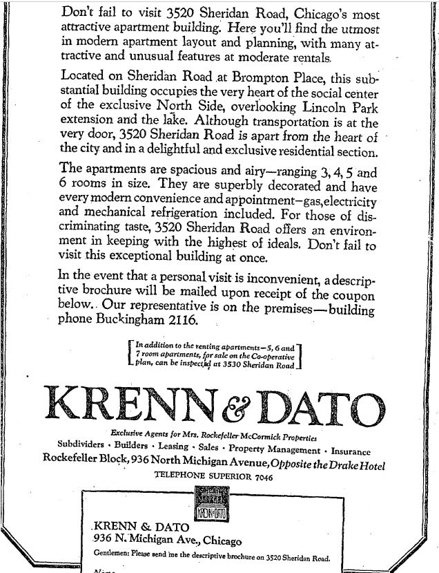


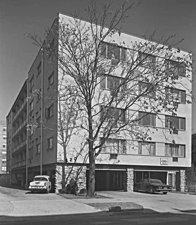


.jpg)


.jpg)
.jpg)
.jpg)

%20(1).jpg)
.jpg)


.jpg)


 2016 photo - Carey Wintergreen


.jpg)


 'The new name Hotel Versey pays tribute to its original namesake The Diversey Arms, while playfully fusing in a tie to the hotel’s


 a demo view below - mysore.blogspot.com


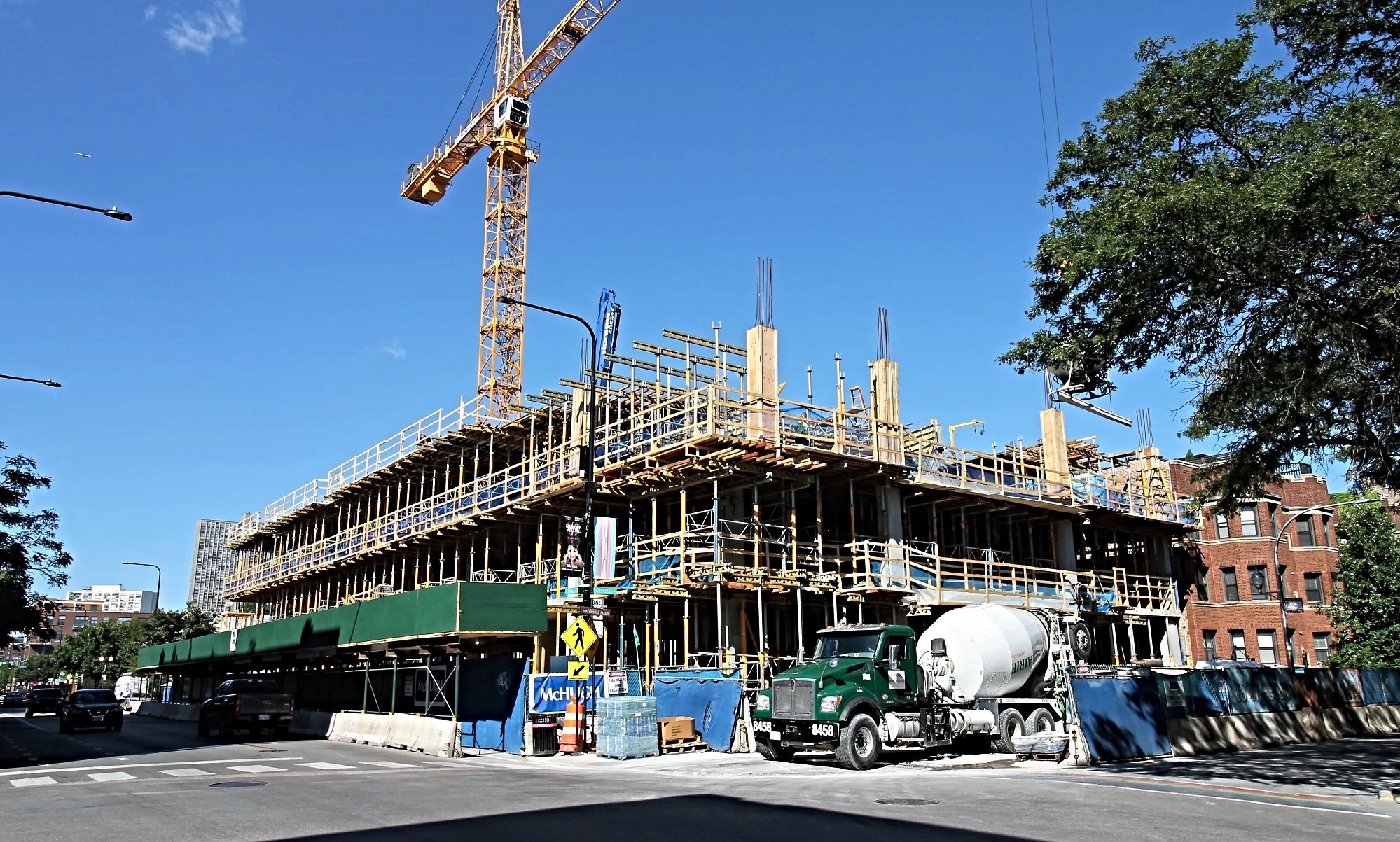


 #2 in 2019 with a crown on top


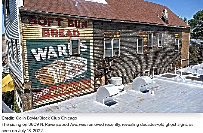


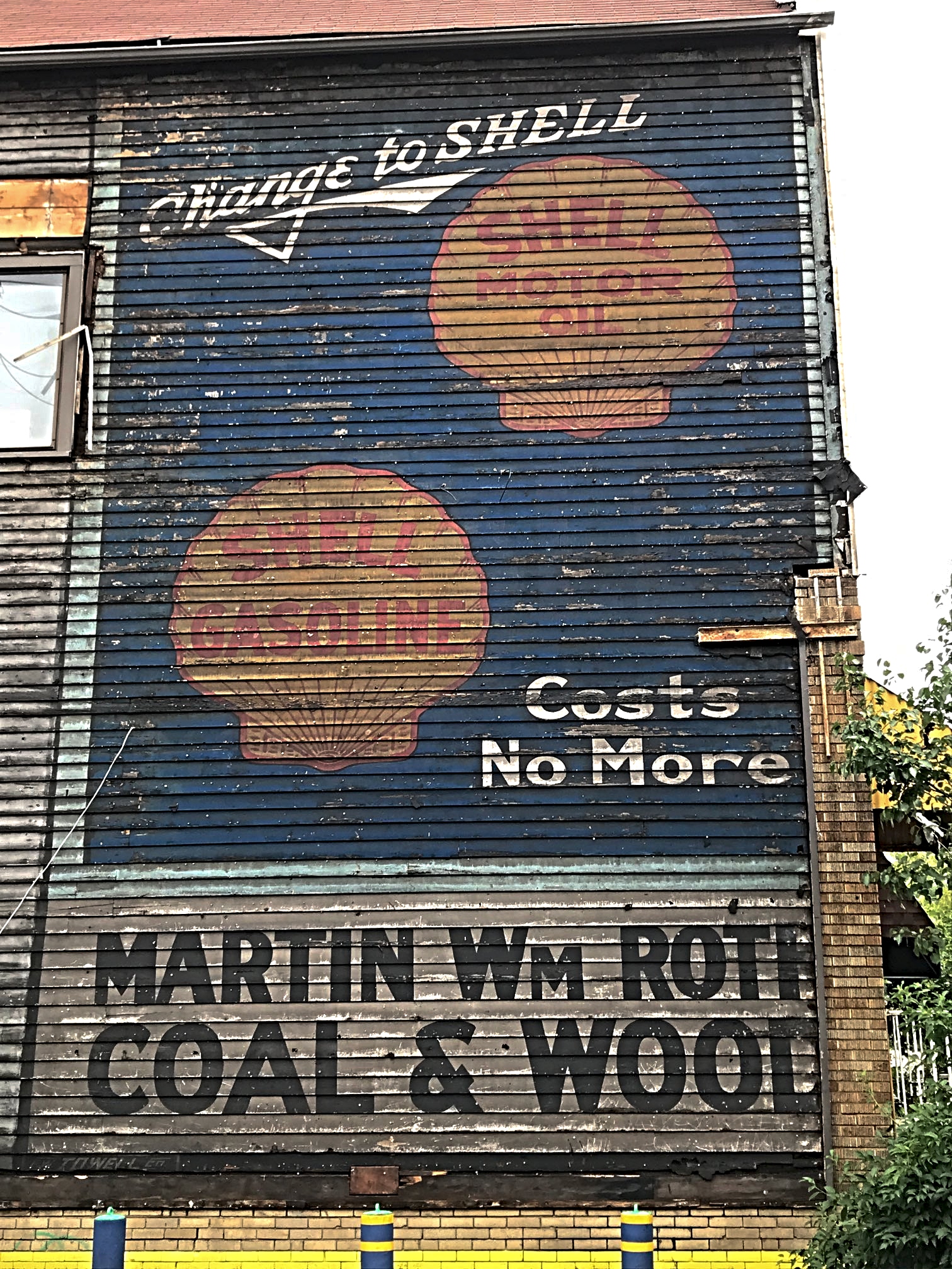


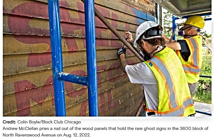


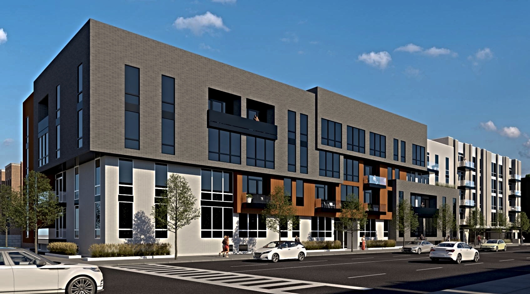


 text - Redfin


 Capt'n Nemo's was known for its nautical theme and
house-made soups, opened in 1992 as part of the mini-chain first launched in
Rogers Park. In 2019, the year Nemo's founder Lou Ragusi died, the Ashland
location closed due to the expense of complying with city codes, according to
Ragusi's son. - per article
Capt'n Nemo's was known for its nautical theme and
house-made soups, opened in 1992 as part of the mini-chain first launched in
Rogers Park. In 2019, the year Nemo's founder Lou Ragusi died, the Ashland
location closed due to the expense of complying with city codes, according to
Ragusi's son. - per article


.jpg)
.jpg)
.jpg)
.jpg)
.jpg)
.jpg)


.jpg)
.jpg)
.jpg)
.jpg)


.jpg)
.jpg)
.jpg)


.jpg)


.jpg)


