Public & Private
Transportation:
that includes
the rail, 4 wheel, 2 wheel types of transports
This post includes reporting on the
RPM/Belmont Overpass Project
'Nocturne Railway Crossing Chicago 1893'
by Childe Hassam via Ebay
A Glimpse to the Past:
Vintage Tracks Discovered
In 2019 during street repairs at 2810 N Lincoln Avenue
streetcar rails were discovered
Maintenance Crew at Work
image below - CTA 2019 calendar/October
[a main road north]
by Ray Noesen
published by Edgewater Historical Society in 1999 (other images inserted within the text)
Much of the [Clark Street]
terrain as well as the function of the road has changed. As one of the oldest
roads in Chicago, it has gone from a narrow meandering trail traversed by
Indians and European traders to a bustling thoroughfare. Straightened out,
paved, lit by overhead electrical fixtures and flanked on either side by
commercial enterprises, Clark Street [originally Green Bay Road] travels through any number of developed
settlement areas that were built and have survived as a direct result of this
ancient road. There were many
thoroughfares that played an important role in the development of Chicago. The
Indian, like his European successor, originally had a choice of routes by which
to travel to his chosen destination. Roads to the south linked the trading
post, and later the city, with eastern centers. Roads that led westward sought
Galena as a terminating point where the Galena and Chicago railroad linked
Chicago with the eastern portion of the United States. In contrast, the
objective of the ancient highway leading north had Green Bay as its terminus
where Fort Howard was an important trading post.
The Native American Trail
Devon to North avenues
map - Chicago History Museum via WTTW
The Green Bay trail began
in Chicago with two alternative routes, each of which gave rise, in the period
of European settlement, to an important highway. The first, which is the one
more commonly identified with Green Bay road, started at the north end of the
Michigan Boulevard bridge and ran north along the height of land between the
lake shore and the North Branch of the river. The route led north on Rush
Street as far as Chicago Avenue and from there northwesterly for a mile to the
intersection of Clark Street and North Avenue. In the earlier life of the city
this diagonal path was represented by a road, but modern city building pays
little heed to the preservation of Indian trails, and all traces of this
diagonal path has long since disappeared. Professor Halsey, an industrious
historian of Lake County, recorded in 1860 that he lived at the south end of
this diagonal, and it was then and for several years afterward known as the
Green Bay Road. Continuing northwest, the trail kept inland from the lake some
distance, coming in sight of it between Chicago and Milwaukee only at Gross
Point (now Evanston). It passes Waukegan three miles inland, Kenosha five
miles, and Racine about the same distance. In 1831, a post office was
established in Chicago and for some time cities for 50 miles around became
tributary to Chicago for its postal facilities. It wasn’t until the middle
1830’s that settlers in any numbers began to turn their attention to the wooded
area to the north of the city. The primary use of the Green Bay road during the
pioneer days of Chicago was as a mail route between the two forts and it is
here where most of our information about the conditions of this road are
gathered.

illustration - Chicago’s Highway: Old and New
Leaving Green Bay on foot,
laden with arms, blankets, and provisions, as well as the mail, the two men
traveled the two hundred and fifty miles following the Indian trail leading to
Green Bay southeast, passing through dense woods of pine interspersed with
cedar swamps and the occasional grove of red oak. Encounters with all kinds of
animal life supplied them with food as well a little danger such as the
occasional encounter with a wildcat. It can be assumed that given the proximity
to the lake of what later became Edgewater, this portion of the area traversed
by these two men was primarily prairie land with sand dunes, tall grass, and
little in the way of trees except along the river banks. While an abundance of
wildlife provided nourishment for the long journey, the real hazards of such a
trip were those of the hardships and exposure of wilderness travel. A Canadian
half-breed who had frozen his feet while carrying the mail from Green Bay to
Chicago became the subject of the first capital surgical operation on record to
be performed at Chicago. The incident took place in 1832 and the surgery was conducted
by Dr. Elijah Harmon, who has been denominated the “Father of Medicine” in
Chicago. The procedure consisted of tying up the man, applying a tourniquet to
each lower extremity, and with the aid of rusty instruments, removing one
entire foot and a large portion of the other. Though Indians during this time
period were generally peaceful, they were liable to avenge upon travelers for
harm done to them by some other European, creating another problem for the mail
carriers. Improvements in the road by the military, though slow, made travel on
Green Bay Road much easier. Read more from the Edgewater Historical Society from the 'title' link above.
Place to Eat & Rest
reference to the word 'West' was to mean Mid-West
in the early 1800's to late 1800's
illustration below - Chicago’s Highway: Old and New
1850 map of transportation routes
The Transport by Rail
by the Early 20th Century
The Gripman - Chicago Cable Cars, Harper’s Weekly 1893 via Calumet 412
Chicago at one time did claim to have the largest
streetcar system in the world, with a fleet of over 3,200 passenger cars and
over 1,000 miles of track – a claim backed up in several sources we found. It all started in 1859 with a horse-drawn car running
along a single rail track down State Street. By the 1880s, a handful of
different streetcar companies were in operation across the city. Gradually, the
horse-drawn lines were replaced with cable cars - so called because they hooked
to a constantly moving cable underneath the street. Electric streetcars powered
by an overhead trolley line gradually replaced the cable cars.
image - thetrolleydodger
This particular 'Brill' is located 'Limits' carbarn once located on
Clark Street between Dewey and Wrightwood
1910 photo - Ebay
According to WBEZ, 'a Chicago streetcar was a two-man operation -“man” is
appropriate here, since CSL crews were all male. The motorman was the driver.
He operated from a standing position at the front of the car. Since his vehicle
was on tracks, he didn’t have to worry about steering.
Fares were collected by the conductor. Passengers entered
at the rear doors, paid the conductor, and passed into the car. When everyone
was aboard, the conductor signaled the motorman by clanging a bell, and off
they’d go. Exit doors were in the front. Car stops were indicated by a white band painted around
the black pole that supported the trolley wire. Passengers waited on the curb,
then walked into the street to board the car when it stopped. Wide streets,
like Western Avenue, had safety islands located in the street next to the
track.' In 1914, the streetcar companies unified under a new
name: Chicago Surface Lines. A nickel would get you a ride to just about
anywhere in the city. The advent of affordable automobiles in the 1920's caused
streetcar ridership to decline – but streetcar operators weren’t going to just
give up. In 1929 they formed the Presidents’ Conference Committee, or PCC,
which determined that the way to stop the decline in ridership was to make
streetcars as fast, smooth, convenient and comfortable as the family car.
Chicago was chosen as the 'guinea pig' city to test two
experimental designs. The winning design became known as the PCC car and was
used in cities all over the country. Chicago ordered 600 of them in 1945 and
1946. Here they were nicknamed Green Hornet streetcars because of their speed
and the Chicago Surface Lines’ green paint job.
At almost the same time the Chicago Surface Lines and the
‘L’ were consolidated as the CTA – and the CTA’s general manager Walter
McCarter wasn’t a fan of streetcars and their unsightly web of overhead wires.
He oversaw phasing out streetcars in favor of buses starting in 1947, just a
year after the Green Hornets went into service. The last Chicago streetcar
click-clacked down Vincennes Avenue on June 21, 1958. There are still lasting vestiges of the streetcar system
in Chicago. Many of today’s CTA bus routes and route numbers are the same as
they were in the days of streetcars. And as for the tracks – a few of the
streets had the tracks pulled up, but most were covered with asphalt and are
still in the streets under pavement.
1910 photo re-enactment below
riding along on Graceland Avenue (Irving Park Road)
Northwest Chicago Historical Society
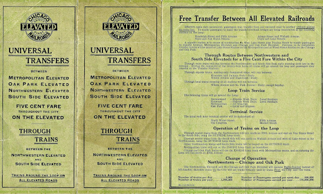
A History Chart of
Early Transport
First 30 Years
of Rail Transit
from 'Chicago L' by Greg Brozo
Newspaper advertisement in 1900


Public Trans on Evanston Avenue by 1893
(Evanston Avenue = Broadway by 1913)
Somewhere between Diversy & Devon Avenue Passengers like Bees to a Hive
in 1893
No Overhead Electrical Wires,Trolley/Cable Companies
by 1897
(all privately owned)
photo - 1899-1903 according to thetrolleydodger.com Charles Tyson Yerkes
'After Yerkes came to Chicago, it was not long before the
street railways caught his eye in his search for profit-making ventures. The
low price of the North Chicago City Railway's stock and its room for expansion
and modernization drew Yerkes's eye and he and his business partners, Peter A.
B. Widener and William C. Elkins, chose it as their first acquisition in 1886.' Read more from the links above.

'In 1881, Charles Tyson Yerkes, then 44 years old, moved
from Philadelphia to Chicago. In Philadelphia, Yerkes had earned a fortune in
banking and with the street railways there. In 1886, Yerkes formed the North
Chicago Street Railroad Co., which acquired the North Chicago City Railway Co.
And in 1887, Yerkes formed the West Chicago Street Railroad Co., which acquired
the Chicago West Division Railway Co. Yerkes thus gained control of all of the
street railways on Chicago's north and west sides.
once located in the Township of Lake View
indicated by this 1887 Rascher's Atlas Map
1891 Sanborn Fire Insurance Map
zoomed belowSample Car Barn
Yerkes later formed several additional streetcar companies
in the outlying areas on Chicago's north and west sides, feeding into his
existing systems. In 1899 [one year after the annexation of the City of Lake View] those companies were combined into the Chicago
Consolidated Traction Co. And in 1899, the North Chicago Street Railroad Co.
and the West Chicago Street Railroad Co. were merged into the Chicago Union
Traction Company. By 1910, those companies had all been consolidated into the
Chicago Railways.
image - Ebay
In 1893, Yerkes moved into the elevated railroad field as
the principal backer in the incorporation of the Northwestern Elevated Railroad
Co. Service began in 1900. In 1894, he acquired control of the Lake Street
Elevated Railroad Co., and also formed the Union Elevated Railroad, which built
the "Loop" which opened in 1897.
In 1897, Yerkes acquired the Suburban Railroad Co., whose
streetcars had served the western suburbs and connected with the competing
Metropolitan West Side Elevated Railroad Co. After gaining control, the
Suburban Railroad Co. routes were changed to connect instead with his Lake
Street Elevated Railroad. In 1901, Yerkes sold nearly all of his transit holdings
in Chicago and moved to London, where he worked on expanding that city's subway
system.'
(all transports were in private hands)
from Fullerton to Wilson avenues
The North Chicago
zoom view below
The Chicago North Shore
zoom view below
The Private Transit Companies Financials


Forgotten Chicago-Facebook contributor Chris Mason
North Chicago Street Railroad 1895 negative - Chicago History Museum
postcard - Ebay
the sign on the streetcar reads the 'Limits' which was the name of the car-station just south of the former City of Lake View's southern border with Chicago - Fullerton Avenue Streetcar southbound
on Broadway approaching Wilson Avenue
image - Edgewater Historical Society
An Evanston Avenue
Transport
(Evanston Avenue = Broadway)
photo - Chicago Transit by David Young
'A steam engine called the dummy' train was used along Evanston Road (Broadway Avenue) from Fullerton Avenue to Graceland Cemetery during 1870's. The first car of this steamed powered train was designed for the engine. The engine was enclosed so that it would look like a passenger car, hence the name 'dummy'. The story goes that if the horses saw the engine they would get spooked.
As a reminder the City of Lake View was annex to the City of Chicago in 1889. This new annexed area was a power-house of sorts in city politics at the time.' - Living History of Illinois & Chicago
Evanston Avenue Residents
say NO in 1893
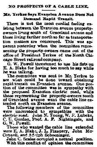

A Minority Opinion in 1893
Bees & Commuters 1893
Citizens Organized in 1893
Protests in 1894
Transport in 1893
Major Railroad &
Cable Routes by 1895
a zoomed view of the north side
New service proposed along Evanston Avenue
Evanston=Broadway
Graceland=Irving Park Road
Jefferson=Lawrence Avenue
Church=Devon Avenue
A Gap in Service in 1895
Electric Trolley Wins Out by 1897
Public Transportation
Routes by 1893

An Advertisement
in 1900
from the Chicago Daily Tribune
a zoomed section from above ...photos - The Trolley Dodger on Broadway just south of Wilson Avenue District of Lake View
The Two Ends
of Old Lake View Transport:
The Car Barns:
Car barns would be basically garages where mass
transit vehicles would be housed and maintained. The most notable
barns were 'The
Limits' and Devon
Avenue Carbarn. According to ChicagoRailFan.com the 'Limits' was coined the
'limits' because it was the end of the line northward along Clark Street for riders from Chicago since era of Lake View Township. Lake View Township territory ranged from Fullerton Avnue to Devon Avenue.
'The Limits'
on Clark Street
a 1887 Sanborn Fire Insurance Map
a 1923 Sanborn Fire Insurance Map photo - Ebay
photo & text - Trolley Dodger
1990's photo - John Keating via Forgotten Chicago-Facebook
1990's photo - Chicago Rail Fan.com
and below - unknown source
CTA's Heritage Fleet that operated their during the 1960's & 70's
The Location
via 1887 Sanborn Fire Insurance Map
when Lake View was township and then a city that same year
The Carbarn
with enlargement
photo - thetrolleydodger
Devon-Broadway carbarn and turn-around
Devon Street Car-House (barn)
mid 1950's photo - TheTrolleyDodger.com
The Map Location
1937 Sanborn Fire Insurance Map
Devon Street was the northern border of the former City of Lake View with its construction in 1901. According to the Rogers West Park Ridge Historical Society the property occupied two complete blocks off Clark Street. The building was closed in 1957 due to the transfer of electrical streetcars to gas powered buses.
Evanston Avenue and Ardmore carbarn
The other notable barn of its time was located in the Community of Edgewater, According to the Edgewater History Society this barn was and still is located at
Another Carbarn
1894 Sanborn Fire Map highlights a car-barn complex owned by
Animal power to motor power in the
Township of Lake View 1866
Township of Lake View
That year the territory of the township
became a city in Illinois
The borders of this area was from Devon Avenue to Fullerton Avenue, Western Avenue to the then existing lakefront
The Early Timeline
of the Elevated
1893 The Northwestern Elevated Railroad Company is incorporated. The last leg of the elevated structure to be built for
the growing transit-using public was that of the Northwestern Elevated Railroad
Company. The company, backed by transit magnate Yerkes, was incorporated in
1893, but didn't begin full service until 1900 due to more financial and legal
difficulties than any other line had experienced. - Chicago L.org.
1895 The Chicago Tribune article-commentary
below tells a tale about the poor service on the Evanston line from a teacher?? from Nettelhoust School.
1890's Read about the twist and turns of the elevated provided
by WBEZ along with an interesting fact about the Sheridan Station (interactive site) elevated route curve. 
'Though at first these horse-drawn vehicles reached only
relatively affluent areas, by the 1890’s public transit had become a central
element in political debate as well as a part of daily life for many
middle-class people and a few of the working poor. In that year, the
"average person" rode mass transit 164 times per year; of course,
little children and very poor people rarely rode at all, but this number
suggested that about one-third of Chicago people were regular riders. By 1916
the same "average" Chicagoan rode 341 times per year.'
1897 The residents of the newly formed District of Lake View protested against a Yerkes land grab.
1900 A train
leaves Wilson Avenue in defiance of a commissioner's order. Four policemen
board at Wrightwood Avenue and placed the crew under arrest. - did not get governmental approval yet.
1903 A franchise is presented to the city counsel to build an extension of the Northwestern's tracks to serve the Ravenswood community.
The Major Rail Intersection
at
Wilson & Evanston Avenue
The Geographical Union of the Elevated
and the Ground Transit Lines

Forgotten Chicago on Facebook, David Daruszka contributor
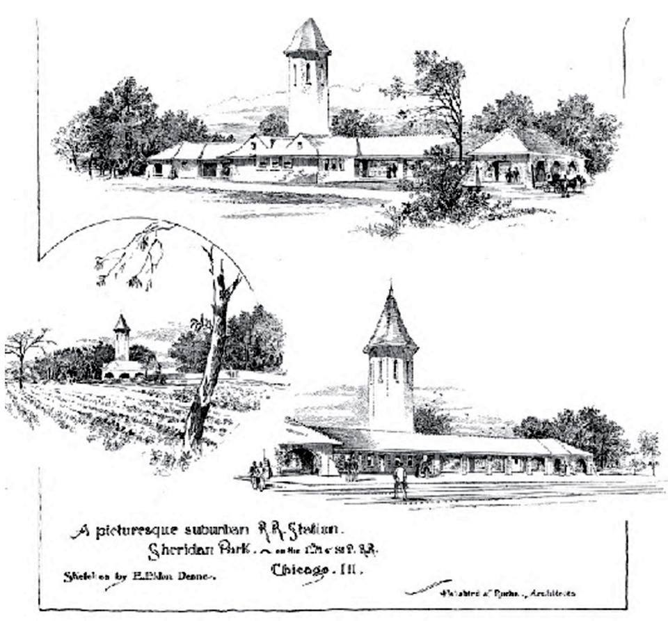
Before the Wilson Elevated Station there was the
ground/service lines at Sheridan Park Station. For a while the elevated and the surface lines would run simultaneously and at the roughly at the same location - Wilson Avenue & Evanston Avenue (Broadway). The Sheridan Station was owned by the Chicago, Milwaukee, St, Paul RR [Evanston Branch] [remembered as the Chicago, Evanston & Lake Superior RR] and the elevated by the Northwestern RR Company [Howard-Jackson/Redline]. The 'Evanston Branch' geographically sliced though Lake View for almost a hundred years.
postcard - oldplaces.org
photo - Chicago History Museum1904 - Sheridan Station Depot on the left of negative
In 1904 the Northwestern Elevated and the Chicago, Milwaukee
& St. Paul Railway reach an agreement allowing rapid transit to come to [Township of] Evanston, via the St. Paul's tracks into the suburb (the two lines meet at
Wilson Avenue). Franchise problems stall an official agreement for another
three years.
1910 postcard - JJ Sedelmair
'When the station opened, one could see the lake from the
elevated platforms. Small farms still dotted the landscape around the station.
But improved transportation brought increased development and urbanization. As
ridership increased on the Northwestern Elevated and more frequent service was
provided, the limitations of the Wilson elevated station were becoming
problematic. The stub-end arrangement increased turnaround time, especially
with the company's early use of a motor car and trailers. The conversion to
multiple-unit operation begun in 1903 helped, but the conversion took several
years and more capacity was still needed. So, as early as 1902, the
Northwestern began developing plans for an additional terminal adjacent to the
previous one, located in the lower yard, where some rush hour trains could be
routed. For reasons that aren't clear, this plan took several years to
implement. The Northwestern placed the new station to the east of the elevated
structure along Evanston Avenue. Trains accessed this "lower station"
using the existing ramp to the lower yard on the east side of Wilson Shops. The
new station included a loop track that turned west along Wilson and then back
south along the west side of the elevated structure. From there, trains could
either enter the lower yard or go back up to the elevated and on to the Loop
via a second ramp on the west side of the structure.' - Chicago L.org

farm country at Evanston & Wilson avenues
photo - Uptown Update via Calumet412
The guts of the Wilson Station Station before the elevated
1900-ish from Evanston (Broadway) Avenue
photo - Chicago History Museum
Lower Wilson Station before the elevated
postcard - Chuckman Collection
3 photos - Trolleydodger.com
and below
the 'Yards' area over the ground rails
photo - Uptown Update via Calumet412
An Account from The Evanston Historical Society:
'St. Paul Railroad (ground transport) and the
Northwestern Elevated finally signed an agreement that permitted the
Northwestern to extend its service into Evanston over the tracks of the St.
Paul, contingent on approvals by the City of Evanston and the City of Chicago.
However, it wasn’t until 1907 that such approvals were given. In March, the
City of Evanston gave its approval for electrification of the line. That
approval was contingent on the tracks being elevated by the end of 1910.
Stations were erected at all the former commuter stops on the [Chicago, Milwaukee,] St. Paul. In
Chicago, they were (in south to north order): Argyle (Argyle Park), Edgewater
(Bryn Mawr), North Edgewater (Granville), Rogers Park (Morse) and Birchwood
(Jarvis). Stations were added at Hayes Avenue (later renamed Loyola) and Howard
Avenue (later renamed Howard Street). Community agitation for stops to be added
at Thorndale and Berwyn date to as early as 1911. A stop was added at Thorndale
in 1915 and at Berwyn in 1916. The Lawrence stop was not added until February, 1923.
Though Wilmette was only a short distance north of Central Street in [City of] Evanston,
the new line was not extended to Linden Avenue until April, 1912.
The Construction Work
along the Ravenswood Line
by Racine/between Roscoe & Newport
1906 photos - Chicago History Museum
the Ravenswood RR & the elevated north of Roscoe photo - Chicago History Muesum
Kissing the Tracks
in 1906
when the tracks are just outside your window
by Garry Albrecht
This story was published by the Ravenswood-Lake View Historical Association in 2018
2000 photo - UIC via Explore Chicago Collection First, some more background.
Public transportation in
the 19th and early 20th centuries were not owned and
operated by local municipalities but by privately owned companies.
One such
company was the Northwestern Elevated Railroad. This company was granted a fifty-year
lease to build and operated transportation rails and stations for the citizens
of Chicago in 1893. The first elevated structure was laid at Fullerton and
Sheffield avenues in 1896. The construction and operation of the elevated had a
rocky start according to ‘Chicago L. org’.
In the winter month of January 1900, the Chicago Public Works claimed
the structure unsound and the company had to end operations. After some apparent
negotiations the Northwestern Elevated Company was allowed to begin operations
again in May of the same year.
image – Chicago L. org
The stations along the
elevated tracks that year north of ‘2400 north’ included the Fullerton, Wrightwood,
Diversey, Wellington, Belmont, Clark, Addison, Grace, Sheridan, Buena Park and
Wilson stations. The City of Chicago
approved the Ravenswood line in 1905 and then was extended to Kimball by 1907.
By 1908 the elevated reached Howard Street. In 1911 the first (voluntary) consolidation of
all privately-owned elevated companies began. By 1947, the Chicago
Transportation Authority (CTA), as we know it, was established.
Typically any company’s financial
bottom-line is to operate for a profit – the more profits the better while
keeping expenses at an operational and acceptable minimum. Companies like the
Northwestern Elevated Railroad used city owned alleyways granted to the company to
reduce those costs of acquiring private property. Municipalities
would allow some latitude on the subject and called the ‘right of way’.
The Buildings to Close to the Tracks
verus
Northwestern Elevated Railway Company
Story by Arlene Nybakken Chase
Arlene Nabakken Chase
resided in Lake View along with her grandparents and parents on Barry Avenue.
She contacted me though my Facebook page, LakeView Historical a few years ago.
She had a story to share about the two buildings that once stood on Lot 20 on
what was known as Noble Avenue; a precursor to the name Barry.
In 1899 her grandfather
received a letter from the Northwestern Elevated Railway Company; a precursor
to what we currently call the Redline. The letter stated that the elevated
tracks were to be constructed along an alley on the south side of Noble Avenue
and would be routed northward east of the two buildings on lot 20. The building
facing the street was leased to a congregation called the Swedish Evangelical
Lutheran Missions Forsamlingen and the other building located behind the church
was the home of her grandparents, Arlene’s parents, and of course her. This
type of property style was common in 19th and early 20th
century. In order to construct the elevated railway, the buildings need to be
altered – the shingles, yes just the shingles of the church needed to be
removed because a legal clearance issue with the city. Her granddad had to
comply with the request. Simply, it was a building too close the future tracks,
a story heard and seen since the elevated tracks were constructed. Anyone can
attest to this while zig-zagging on a train car on the Redline.
The entire letter below
a letter segment of the notice
1412 Noble Avenue = 946 Barry Avenue
a closer view of the entrance to the house in the back
the house in the back had enough distance from the tracks
All photos are
from Arlene
Nybakken Chase
Arlene stated that "My father built the archway leading to our house at 946.
That long gangway was scary at night, so dark. Dad would send me for the Sunday
Tribune which came out on Saturday night, and maybe a bottle of ginger ale from
'the corner store' and he would promise to stand on the porch 'til I
returned. Sometimes he'd go inside for a minute and if he wasn't there, I was
terrified. Many bad characters hanging around that area at that time. I saw
more than one "flasher" hanging around under the El tracks. Momma would say, "Just run away!""
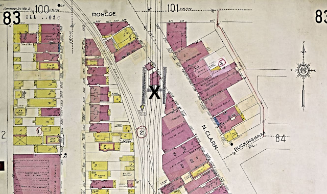
The Maps:
X marks the spot
of Block 3 that lot 20 is located
X marks the spot
Section 8 of the above map
zoomed further to show Noble at Sheffield - lot 20, the future location of the two buildings
The Sanborn
Fire Maps below will further assist
in the location of the two buildings and future
and
present locations of the elevated tracks
*Redline was formerly called the Northwest Elevated
and then later Howard Line*
1891 Sanborn Fire Map
eight/nine years before the elevated was constructed
Notice the alley on the south side of Noble Avenue was used to route the Northwestern Elevated Railway tracks and how close it was to the buildings
1894 Sanborn Fire Map
for some reason or another the building/church is now gone and the house in the back remains at 1412 & 1414 Noblie Avenue
1923 Sanborn Fire Map
Noble = Barry
This map shows the tracks that replaced the alley and some of the buildings north & south sides of Noble Avenue 1950 Sanborn Fire Map
zoomed below
This the 1905 blueprint
that highlights the required adjustments that were needed per her father's letter
zoomed view of the map
It would appear both buildings may have been effected
The alley (new tracks) to the right and the street to the left
*Barry Avenue was once called Noble Avenue*
zoomed further
highlights the 'edge of shingles' that most be removed
a view from her bedroom/east of the elevated
Arlene, the granddaughter of Nels
Anderson indicated the sign in the photo above would make her feel hungry when
viewed out one of the bedroom windows. Apparently, all generations learned to sleep soundly next the periodical noises
of the L until 1947 when the family moved out of Lake View.
All the images minus the edited Sanborn Maps are photos and artifacts that are owned by Arlene Nybakken Chase. I found her story first online and then she offered the rest of her to story to me for this newsletter. She indicated that all the photos in this story may been lost forever if not for her grandmother who retrieved them from a trash can. In 2022 she donated to me countless deeds of the houses.
a view of the elevated tracks from the family's property
The below photo is the entire family hanging out on the porch of their ‘home in back’ – three generations worth
Both Buldings Gone
as of 2009
The Deed Tablet
donated by Arlene Nybakken Chase
to me in 2022
This deed table records the ownship of the property
from 1834
zoomed below
a record pages for 1886
when Lake View was a township in Cook County
another sample page
zoomed below
another page
another pageX marks lot 20 - their property lot in Block 30
another page apparently Arlene's relatives owned
lots 18,19,20 at one time
More Deeds
to the Church & House
other deeds of both buildings of 1412 & 1414
(there are many more)
all these deeds were required due to the structural change of the buildings and the area east of the buildings (tracks) along with address number and name changes from 1899
Historical
Developments
Continued to the North
all within the newly formed
District of Lake View
photo - J.J. Sedeimaier via Chicago L-Facebook
1907 To relieve congestion, a new "lower Wilson Avenue" station and a loop track was built and put into service, with express trains
routed to it. Also, that year Ravenswood service is inaugurated at Western Avenue.
Citizen's Complaints of the Ravenswood in 1907
1908 Howard Avenue station finally opens, late due to construction delays. Also that year, the construction of an elevated embankment begins in Evanston.
1914 The Chicago City Railway, Chicago Railways Company, Southern Street Railway, and Calumet and South Railway merged to form Chicago Surface Lines - an operationally united but privately owned rail system.
1914 map - Chicago Transit and Railfan
red dots indicated car-barns
The Rails
Above the Streets
image - Chuckman Collection
This poster shows all the elevated companies
of this time period - all were privately owned
Can you pick the stations
that no longer exist today?
1914 map
highlights the stations
(1900-1960) below photo - Chicago L .com
1916 Trains on the Lawrence-Howard stretch were moved onto a temporary wooden trestle, allowing the demolition of the original tracks and stations. Construction of the permanent embankment were slowed due to manpower and material shortages caused by World War I.
1923 The new station at Lawrence Avenue opened. Later in the year, a newer and larger station was constructed at Wilson and the original terminal yard is demolished.
Chicago Rapid Transit Company
A 1924
Rail Car Design
a 1924 transit ticket - Ebay
1924 Samuel
Insull, a utility magnate who took an interest in public transportation and a
visionary, realized that for the sake of the ‘L's continued longevity, it would
have to be completely consolidated by publicly held entity, with all the
companies officially merging into one. At that time their were four independently owned and operated ‘L’ lines of
which the North Western ground rail system was of one. The Chicago Rapid
Transit Company accomplished this and under the CRT, the 'L' service was funded
by State of Illinois.

Mirroring the country as a whole, the various companies that made up the Chicago "L" coasted through the 1920's on the misguided belief that the good years would never end. It was a time of unbridled prosperity and optimism for America of which the Chicago transit companies proudly demonstrated in their capital improvements during this time. Although ridership was the highest it would ever be, it was utilities magnate Samuel Insull's vast and profitable network of companies that helped offset the usually unprofitable "L", financing new construction, upgraded equipment, and infrastructure improvements. Without Insull's immediate capital improvements it is unlikely that the Chicago "L" and interurbans would have survived the Great Depression. Insull's generous civic spirit and love for the Chicago area also seemed to motivate this desire to acquire and improve these electric lines as much as bottom line profit possibilities. But little did Insull or the "L" know the reversal of fortune October 1929 would bring.

'The Chicago Motor Coach Company was formed in 1923 after a merger of three motorbus carriers, Chicago Motor Bus Co., the Chicago Stage Co., and the Depot Motor Bus Lines.
In 1924, John D. Hertz merged Chicago Motor
Coach and the Fifth Avenue Motor Coach Corp. of New York City, creating the
Omnibus Corp. In 1952, when it owned nearly 600 buses, Chicago Motor Coach’s
operations were taken over by the Chicago Transit Authority (CTA), the city’s
public mass-transit enterprise. With fifty in operation the buses will run from three to
six minutes apart.
The first bus made the trip downtown in forty minutes. The company proposed to shorten this schedule to twenty-five and thirty minutes. Express
and local buses will be a part of the system. The fare was ten cents. At present
the buses stop whenever hailed at street intersections. The route was from Devon avenue south on to Sheridan Road
through Lincoln Park, the Lake Shore Drive and to Ontario
street, to Rush street, to Michigan avenue, to Randolph street, to La Salle
street to Adams street, to the terminal at State street. The buses run from 6
o’clock in the morning until 1:30 at night. They are manned by a chauffeur and
conductor.'
- Chicagology
1940 map - Barry Lawrence Ruderman Antique Maps
zoomed for our area
no date photo via Ron Tamulis
'Chicagoland Before We Were Born'/Facebook
a #151? heading north and south through Lincoln Park
a 1936 photo of the #146 below
video - YouTube
Tickets,Tokens & Brochures
Samples of Tickets
images below - Ebay
by WBEZ
Guide
part of my personal collection

Motor Coach only


Lincoln Park, the park was at Bryn Mayw Avenue


1942 Transportation Map
pre CTA
part of my personal collection
zoomed view below
The stars represented elevated Chicago Motor Coach Transfer Stations per this schedule brochure
The CTA Begins in 1947

image - from a CTA 2018 calendar
1947 The Chicago Transit Authority begins operating Chicago's rapid transit trains after purchasing the privately owned Chicago Rapid Transit Company for $12 million.
1948 New CTA Map - click on link to enlarge along with backside
to replace the older fleets
OUT with Old and IN the New
rolling out the signs in 1954
photo above - CTA web via TimeOut Chicago The Last Run on Route 36
photos - Trolley Dodger

1950ish pamphlet - Ebay


1964 images - Ebay
The A/B System
- increases train speeds, thus making the service more
attractive for passengers. This benefit is extended to passengers on all
portions of the routes
- provides service frequency somewhat proportioned to
riding demand by giving the more heavily patronized local-stop stations more
frequent train service than relatively lightly used "A" and
"B" stations, permits fine adjustment of headways without the handicap
of severely unbalancing loading between trains as is the case with more
conventional local-and-express service, and
- reduces car requirements, manpower requirements and
operating costs compared to all-local or local-express plans.

images - York M Chan via LakeView Historical-Facebook
with a more local zoomed look below
a 1974 Marker
L stop markers signal light combinations
Ray Piesciuk via Forgotten Chicago-Facebook

(video)
of the 6000 series CTA cars near the Sheridan L Station.
The 6000's were used by the CTA from 1950-1992
initially by David Harrison &
copied by Vincent Ecter on Facebook
1983 photo below - Lou Gerard via Chicago L - Facebook
1993 On February 21, 1993 the Howard branch was combined with the Dan Ryan branch creating the present Red Line.
1994 The CTA changes the last of it's route names to a code color. The lines are now as follows: Red Line (Howard-Dan Ryan); Blue Line (O'Hare-Forest Park-54/Cermak); Orange Line (Midway); Brown Line (Ravenswood); Purple Line (Evanston); Green Line (Lake-Ashland/63-East 63rd); and Yellow Line (Skokie Swift).

image - Ebay
(video) south to north
pedestrian overpass bridge above
the former Clark Street Station to the left
1999 The CTA retires the token as the exchange for a ride accepting only Transit Cards and cash fares
(on buses and in turnstiles) as payment.
2012 CTA may offer 'naming rights' to rail stations to corporations to enhance their budgets for construction.
(video)
from Howard Street south to 95th
the former Clark Street Station to the right
Speed Innovation Plans
in 2017
photo below - Marty Bernard
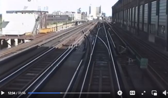
Chicago Transit Authority northbound Ravenswood train crossing over at Clark Junction and Tower and blocking all four tracks. This does not occur anymore due to the new flyover. The old tower is gone also and the new tower is on the right of the four tracks closer to my camera. The shot is from the now gone bridge over the tracks at the Belmont Station on thr frosty morning of December. 14, 1972.

the new route vs the old one the overpass just beyond the Belmont Station northward
This idea is not new
New York City planners had this idea in 1879

will be Gone!
a 1907 view of the tracks viewed south (Howard/Redline) along with a view of its Ravenswood underbelly
2016 view from Google Earth of what
remains of the old station platform/tower at the 'V' juncture
(Redline to the right & Brown line to the left)
a 1950 Sanborn Fire Map view
station on Clark Street
with the switching tower south of the station
Clark station was supplemented with an interlocking tower in 1906 when the Ravenswood extension was built, connecting to the main line just south of the station. It still retained its platforms, functioning as a station for Wilson-bound trains, but not Ravenswood - Chicago L.org
the Belmont Station belowzoomed belowabove photo - Chicago L. org
below 2002 photo - Chicago Tribune
2017 photo - Curbed Chicago

The Clark Street Junction Tower on School Street/Sheffield
photos - David Harrison via Chicago L/Facebook
2000 photo - UIC via Explore Chicago Collection
Robert Murphy photographer
2019 Google view above
2021 Google view below
 CTA images above
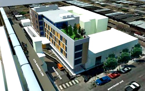
The CTA announced in April plans to construct an additional track at the Belmont station, which connects Brown, Red and Purple lines. This plan would demolish at least 16 buildings so to make this project viable. The $320 million project, which would be funded with federal grants, could alleviate delays throughout the entire system. In November election 2014 the voters in the effect precincts will vote on the project. Listen and view about
this project via Chicago Tonight. The opposition had a Facebook presence but Streetsblog mentions the opposition is vocal but not the majority on this issue. In January 2017 weeks before a new federal administration was sworn-in the CTA received their funding for all the CTA planned projects that included this controversy one. 2017 Google Earth
of the area effected
2017 Google Earth of the area affected
just north of Belmont Station
A new federal administration had different priorities
The 2016 presidential election created a time sensitive happenstance. A future Republican administration would probably not fund this infrastructure project so the race was on to grant the new funding before January 21st to the CTA.
But Approved 2017
The funding includes the following:
According to the CTA the first phase of RPM will be to rebuild the Lawrence, Argyle, Berwyn and Bryn Mawr rail stations and more than a mile of adjacent tracks and track structure. It will also construct a Red-Purple bypass to improve service that will benefit the entire Red Line by improving reliability & increasing capacity so that more trains can be added to alleviate chronic overcrowding during peak travel times.
all images from CTA
A Belmont Plaza?
'Based on an informal review of responses from the Lake View meeting, neighbors gravitated toward a few specific concepts: adding affordable and diverse housing, retaining historical buildings and creating pedestrian friendly streetscapes with traditional architecture and small businesses. Neighbors wrote that a plaza on Belmont Avenue would "serve as [the] heart of Belmont strip" and become a gathering place for events like farmers markets or the Belmont-Sheffield Music Festival. One possible area for such development is the patch of gravel to the east of the Belmont "L" station, left abandoned and poorly maintained, neighbors have said over the years.' - DNAinfo
The 16 dark green properties include buildings that
will be displaced according to the CTA

photos - DNAinfo
DNAinfo reports that the several year project includes plans to rebuild the 100-year-old embankment that supports the track between Lawrence and Bryn Mawr avenues, making it possible for six to eight more trains per hour to travel from Howard to 95th streets on the Red Line.
The Building Demolition
Begins in 2018
According to Preservation Chicago 'Buildings slated for demolition include five buildings on the west side of Wilton Avenue, between 3240 and 3252 N Wilton Avenue, four on Clark Street, including 3334-3344, 3346-3348, 3366 and 3401-3407 N Clark Street, plus 947 W. Roscoe Street. Scheduled for fall demolition are four more buildings on Clark, including 3328, 3413, 3415-3419 and 3421 N. Clark Street.'
from the CTA via Triangle Neighborhoods Association
Demolition Targets
Along Clark Street
photos from Google Maps
After removing the angular building they discovered
a 'ghost sign' in 2018 - a Bankes Coffee sign ...
The Ghost Sign Discovered once located at 3413 N Clark Street
there other location in Lake View
was 3421 N Lincoln Avenue

Chicagology called this coffee store the Starbucks of its day2018 photo - Laura Radtke a 1927 advertisement below
ad images - Chicago Public Library
above 2018 photo - Chicagology
below 2019 demo photo - Dasson Wallace
Other Target Buildings 2017 photos from Google Maps

to this building on March 30th 2018
by Sam Prus via Forgotten Chicago-Facebook
Demolition Targets along Wilton Avenuefrom Belmont to School Street
2017 photos from Google Maps
also
Advocate Illinois Medical Center
was part of the hospital complex once located
at 3030 Wilton Avenue
that was built in 1991 as apartments
and a residence on
a hole along the street 2021
A Naked Landscape
along
Clark Street/Roscoe
in 2018
southwest view from Roscoe/Clark Street
and the other side of the tracks southwest view along Clark Begin in 2019
all images from the 44th ward office - Tom Tunney, alderman
Last summer Com Edison rerouted all the electrical lines in the impacted area effected by the demolition of the effect buildings. The work on the 'overpass' began in 2019
Four million dollars
in improvements planned
for this station as a prep for the Belmont Station Overpass


Prepping for Change
at Addison Station
2019 photos - Garry Albrecht


Early Prepping in the Autumn 2019
Per Curbed Chicago
According to Curbed Chicago in addition to the overpass elevated south of Belmont Station “The project will rebuild a six-mile section of century-old section of tracks between Lawrence and Bryn Mawr stations and construct a new rail bypass bridge just north of Belmont station. The Lawrence, Argyle, Berwyn and Bryn Mawr Red Line stations will be made fully accessible and close for more than three years. Temporary stations will be opened during the closures. The bypass construction is expected to finish at the end of 2021 followed by new track lines between Belmont and Newport /Cornelia ending in 2024. The station reconstructions will begin in late 2020 and wrap up in 2024 - total of 23 track miles will be updated to improve signals, flow, and reliability.”
Per Chicago Block Club
According to Chicago Block Club “CTA officials have said the current track alignment is the equivalent of having a traffic signal in the middle of a busy highway. To add more trains to alleviate overcrowding, getting rid of that “traffic light” is essential. By building the bypass, the CTA previously said it could add up to eight trains during rush hour on the Red Line alone and ultimately would be able to accommodate 7,200 more passengers per hour on the three lines.”
on Clark toward Roscoe new vs old ...
view south over Clark/Roscoe


The Butterflies

One resident, however, is displeased with the installation. “I think the butterflies are an attempt to make it more beautiful, but they’re slightly gaudy,” said Anna Mancuso, whose house sits on east Wilton Avenue, facing the construction site. Mancuso said she and her husband asked the CTA to plant trees to block dust from construction and the sound of train traffic, which she says has heightened after the demolition of the homes across the street. For the Mancusos, the construction has made the area far less homey. “We miss having a neighborhood,” she said. While she isn’t a fan of the butterflies, Mancuso does appreciate the CTA putting in floral arrangements. “The flowers are what’s beautiful,” she said.
“I love the flowers.”
photos - their Facebook page
2020 Google view towards the tracks
'In a Facebook post announcing the move, Pick Me Up management paid homage to the “community of misfits” that became the business’ “de facto family.” With the massive changes that have come to Wrigleyville in recent years, the move would allow Pick Me Up Cafe to be in a location more suited to the business.'
- Chicago Block Chicago
A Permit Approved
3356 N Clark Street
was located under and between the tracks
Red line tracks are in the forefront and the Brown line tracks to the right in the backgroundThe Clark Street CTA substation was demolished and then will be reconstructed on the southeast corner in order to facilitate construction of a new track; new steel beams and modified joists to support the lowered roof. Work includes architectural, structural, mechanical, electrical, plumbing, and communication systems
– per Chicago Cityscape
Google map & satellite view of the substation
An Email Alert
I registered for periodic email alerts from the CTA so to keep me in the loop on the construction news from 2020 to 2023
location of this particular alert site
 A Covid Virtual Meeting
 Moving a Building
located in a Chicago Historic Newport District
moving it 35 feet toward Clark Street from the tracks


Permit Issued in December 2020
[This building has] '6 dwelling units, 3 story, non-occupied structure, no parking. historic building to be relocated 29' west and 4' south of its existing location in order to facilitate construction of a new track structure. the relocated building will bear on combination of concrete strip footings with integrity cast concrete foundation walls, and individual spread footings. all existing electrical, mechanical, and plumbing connections to be disconnected prior to relocation. new utility connections for electrical, gas, sanitary and water. interior buildout to be permitted separately.' - Chicago Cityscape2019 Google photos
view southwest on Newport
view west of the tracks along the alley
view southwest on Newport east of tracks view east on Newport
view northeast from Clark Street
and below an east view from the corner of Clark & Newport
Space between the building and the tracks
by 2023
here is a few below
Then and Now
Comparison
This is a 1929 negative from the Chicago History Museum about 920 W Newport west towards the tracks and the Vautravel Building to the left of this photo with its then domed top
below a 2009 Google view
The Online Meeting
Begin
Due to the pandemic all meeting were online
October 2019
photo via Curbed Chicago
'The $2.1 billion project was first discussed in 2014, and now the starting phase is kicking off in Lake View. The project will rebuild a six-mile section of tracks between Lawrence and Bryn Mawr stations and create a new rail bypass bridge just north of the Belmont station. While the construction starts today [October 2019], residents have already felt the inconveniences of long-term work. In May, the Lawrence, Argyle, Berwyn, and Bryn Mawr Red Line stations closed for three years so the city could make them fully accessible. Temporary stations are open at Argyle and Bryn Mawr.'
- Curbed Chicago
Per Alderman Tom Tunney/Facebook
"Broke ground this morning on the Chicago Transit Authority's RPM Project at Belmont [Oct 8th] with Mayor Lori Lightfoot, Senator Dick Durbin, Congresswoman Jan Schakowsky, Congressman Mike Quigley, Alderman Howard B Brookins Jr and neighbors along Wilton Avenue."
Construction workers are in January of 2020 are excavating 70-foot-deep shafts for the foundation for the Belmont Bypass, a key part of the CTA’s $2.1 billion Red-Purple Line Modernization Project. Construction on the bypass is now in its third month. It’s the most ambitious public transportation construction project in the city’s history, playing out in one of Chicago’s most densely populated neighborhoods. One of the many obstacles faced to date is avoiding underground utilities that are almost a century old amid the excavation. - Block Chicago Club
Micropyle Drilling & Installation Notice

map of construction zone
photos - Chicago Cityscape
Wilton & School
along Wilton north of Belmont
The Summer of 2020
The ridership is down due to the pandemic
a RPM banner along Belmont & west of Wilton Avenue
photo - Garry Albrecht - me
A Feedback Notice 2020
A November 2020 Report
Early Construction Photos
by Central Lake View Neighbors Association
near Clark/Roscoe toward School Street
Wilton toward Clark /Roscoe
pass the watch tower on School Street
the bypass over Roscoe/Clark Email Alert

Sheffield Ave. closure Janurary 2021
by Buddy Casanova - Chicago L-Facebook
along Clark Street south of Roscoe
CTA RPM/Facebook photos along Wilton Avenue view south toward Belmont Station
below view north from Belmont Station
the support beam
in Spring 2021
Work on the $2.1 billion Red-Purple Modernization Project is expected to significantly ramp up in the coming months, when crews will begin to demolish and rebuild four stations and track infrastructure between Lawrence and Bryn Mawr in Uptown and Edgewater. Two virtual meetings will be held this week. CTA officials will update neighbors on the construction timeline and expected work. The meetings will be location-specific. At 6 p.m. Tuesday, officials will discuss the Lawrence and Argyle station area’s timelines and impact. At 6 p.m. Thursday, officials will discuss the Berwyn and Bryn Mawr station area plans. To register for the meetings, click here. Neighbors can attend one or both meetings. In January, the CTA unveiled designs for the newly rebuilt stations at Lawrence, Argyle, Berwyn and Bryn Mawr. Crews have already begun to work on temporary stations at Argyle and Bryn Mawr that will allow for continued “L” service while the new stations are being built. - Block Chicago


Old & New in 2021
photo looking south at the intersection of Clark and Roscoe
by Jon Chefflings
April 2021 photos - Garry Albrecht, me
I personally wanted to take a closer look one still chilly afternoon.
The location were the Roscoe/Clark - Roscoe/Sheffield intersections
just north of Roscoe on Clark
the double tracks underbelly
the main cross-over brace facing Clark south of Roscoe
walking west on Roscoe toward Sheffield
view southwest from Clark south of the Roscoe southeast corner
views southwest from Clark/Roscoe
view from Clark/Roscoe northwest
view of the southeast from Roscoe
the under belly of the old to be replace tracks below
directly south from Roscoe below
between Clark & Sheffield
northeast corner of Roscoe/Sheffield
view southwest and west from Sheffield

below photos Wilton north of BelmontAerial Views
May 2021
Wrigley Aerials via Twitter
another angle - north/south
zoomed view belowRolando Moreira's Journey
around the curve from Ravenswood
the X marks the range of the photographs
*the Redline is in red*
Google Earth view east above Google Earth view north below
the construction of the new tracks, at this point, end or begin east of Seminary Avenue
2021 Photos from Rolando Moreira
on the old tracks heading east toward the curve 
making the curve below
below the tracks is Sheffield/Roscoe
to the left of photo is Clark Street just north of Roscoe Street
we now heading south toward the School Street tower
(to the right of photo) with Clark Street to the left of photo
toward Belmont Station
April 20212021 photo prior to the relocation
The Initial Steps
the removal of the back porchphotos by CTA RPM-FacebookDigging Down & Slowly Moving
photos from Carter O'Brien June 2021 Ready for the Actual Move
to Clark Street
Inching westward toward Clark Street
More Photos from Carter O'Brien
moving along the movers rails ...
Now, Let's Pause & RecapThe First Overpass!! sorta
by Greg Eagel
Removal of the Old Tracks
one rivet at a time
Renovations north of Lake View as of July 2021
Laying on the tracks in August 2021
photo - CTA RPM
The Last Piece
of the Track
and
after photos

RPM photos & text
photo below - Manu Loop
fitting into place just nicely
This Phase
is Done!!
Replacing the old tracks
from Belmont to Cornelia Begins
with Future Plans in 2022
a CTA video
Original Chicago/Facebook/gerriwhitley IG
Alerts Continue in 2022
The Removal of the original Tracks
in 2022
Beginning of the Old Tracks Removed
March 2022
Closure of Clark and Roscoe for CTA Work -- March 4-9
The CTA will be performing track demolition along the intersection of Clark and Roscoe as part of their Red and Purple Modernization project. The construction begins tomorrow and is expected to last until March 9th. The intersection will be closed 24/7 during this time. Detour signs will be posted along neighboring streets to redirect traffic accordingly. CTA train service will not be impacted. The posted vehicular reroute will be to take turn east off Clark onto Aldine, turn north onto Halsted, and then turn west onto Cornelia.
with the Clark #22 rerouted
Repairing the Damage
 The Next 4 Months' Schedule


Removing the Old Tracks
2022 photo - John Lit
at Clark & Aldine
Its' Not Completely Done
as of 2022
Track Structure Demolition & Foundation Rehabilitation
emailed all in one dayAnother major project in RPM Phase One is a complete signal system upgrade from Belmont to Howard! The newest addition is the Clark Junction Relay House, which controls the busy junction point between Red, Purple and Brown Line trains just north of Belmont station, - text & photos CTA RPM
The Next Phase:
Evanston Express/Purple Line Tracks
The Next Phase
2023-2025


Replacing the Old Tracks
with New Ones

laying the new tracks to replace the old
cementing for the new tracks
and then I ask
a question
What about the vacant property?
Thanks for your question! At this time, no decisions have been made regarding the current CTA-owned construction lots that will be released after the completion of the RPM Phase One project. For the development sites, a Transit Oriented Development plan was created prior to the start of construction in 2019. You can view those documents here: https://www.transitchicago.com/rpm/documents/. As background, the RPM project required the acquisition and demolition of properties in order to locate new track structure and stage construction. From the outset, we anticipated that portions of the CTA-owned land impacted by RPM Phase One would no longer be needed after construction was completed, and our goal has always been to return this surplus land to active use through redevelopment as soon as possible once RPM Phase One construction is complete. As noted in the report, we expect that 12 months prior to the contractor no longer needing access to the TOD parcels that CTA would solicit development proposals through the Request for Proposals process. We expect the RPM Phase One project to be completed in the latter half of 2025, so we plan to have conversations with the alderman’s office and stakeholders starting in 2024. We will keep residents informed as we prepare to begin the TOD process.
Still Replacing the Old Tracks
Most Challenging of
Future L Station Projects
3940 N Sheridan Road
built 1900
renovations 1916 & 1930

Does the CTA plan need another overpass??
My Route Suggestion
View my dotted lines that avoids Byon's Hot Dogs but demolishes some 2-flat buildings and fly-over the Sheridan L Liquors building
.jpg) photos of the L station below
photos of the L station belowstill with the orginal markings that indicates the previous administration - [Chicago] Rapid Transit
the one of the two stairwells to the platform2913 photo - Chistopher R
view of platform northwest
view of platform southeast 2012 photo - Brandon T
2013 photo - Jason T
2012 photo above Ryan B
2012 photo below - Brandon T
Possible Effected building to be demolished for my route to be realized
2020 Google Map photos
view east
Suggestion?
The Continuation of Redline
Track Replacement
Replacing the Old Tracks
Continues
News Further
North
Uptown & Edgewater
as of 2023
photo - Block Club Chicago 'The CTA today announced a major, new enhancement to the transformational $2.1 billion Red and Purple Modernization (RPM) Phase One Project that will create more than one mile of new, open space underneath Red and Purple Line tracks in the Uptown and Edgewater neighborhoods. The new community space will be created between W Lawrence and W Ardmore avenues by removing nearly all of the century-old embankment structure and walls starting later this year.
At the completion of the RPM Phase One Project in 2025, the Uptown and Edgewater neighborhoods will gain new areas that could be developed into parking and community spaces, by removing a physical barrier that has separated the community for more than 100 years.
The embankment wall removal is a significant change and enhancement to the CTA’s historic, ongoing RPM Phase One Project. To begin the conversation of how to develop the space following completion of the project, CTA today announced it will hold community meetings for a block-by-block look at new space that will available with the elimination of the wall.' - CTA
Nearing the End of the this Segment
of the RPM/Belmont Overpass Project
Replacements of old Tracks Continue
in Lake View
Januray thourgh April 2024
Feburary 20242021 Google Map views of the old tracksat theat corner
notice - 44th ward newsletter
hh
2018-2022
more detail reporting
in my post called
a more detailed accounting in my post called Northside Transit'As part of the first phase of the Red and Purple Modernization (RPM) Program, CTA has begun construction of the Red-Purple Bypass north of the Belmont Station to eliminate a bottleneck that prevents CTA from adding more trains. Currently there is a flat rail intersection, and all northbound Brown Line trains cross over the four tracks used by northbound and southbound Red and Purple line trains. This outdated track configuration dates back to 1907 and results in inefficient train operations that constrain the CTA’s ability to add train service.' - CTA

The Before
& The After
The CTA would email me alerts on the construction phases
and virtual meetings such as the one in 2018

photos - Trolley Dodger
Roscoe & Clark Area
The Ghost Sign
When certian building was demo'ed for this project a 'ghost sign' was discovered on one side of a building
Sound Barrier Installation
in 2023
Nearing the End of the this Segment
The Re-Construction in Lake View
Enters its Final Phase
October 2023
Community of Uptown
former District of Lake View

Beginning in 2015 the Wilson Station renovation began so to once again become the super hub of the northside. I have devoted a lot of space on the Wilson Station due to its importance to the Howard (Red) Evanston (Purple). This station and the Belmont Station once served the former North Shore Line that took folks to Milwaukee, Wisconsin while stopping at several stations along the North Shore.
1900ish - Chicago L.org
1900ish photo - J.J. Sedelmaier via Uptown Update
with a view of the same photo in 2009 via Google
and view of of it in 2019 via Google photo & text from a book called Chicago:growth of a metropolis
The first building vs the second building
Ron Tamulis, Living History of Illinois & Chicago - 1899
Its focus was the transfer of commuters to and from the Chicago North Shore and Milwaukee Wisconsin
Curt Seeliger via Chicago L-Facebook
notice the freight trains
photo - Lou Gerard via Chicago L-Facebook
apparently the former freight train only tracks
were used for the Evanston line?
Ground and L Views
the maintenance building was located east of the tracks
photo - via Ronald Jackson
photos - Trolley Dodger
Photos of the Buena Yard
south of the Wilson Yard
1973 photos
according to Chicago L.org the Buena Yards closed by 1973.
The Buena Yards stretched from Irving Park Road
to Montrose & connecting with the Wilson Yards
image above - Uptown Update
 West of the Redline (Howard Line) were the tracks & yard for the Evanston branch of the Chicago, Milwaukee, & St. Paul. This railroad cut through Lake View like a knife with factories and homes constructed around it since its construction in the last quarter of the 19th century. This line was meant for freight only while the elevated was designed for commuters.
view northward below - unknown source/date
highlights the Wilson Yards center right
Inside the once
Wilson Yards
photos - Lou Gerard via Chicago L-Facebook
1970's photos per Lou Gerard
a repair bay


images above - Chicago Transit Authority-Facebook
Lou Gerard via Chicago L-Facebook 1973
Lou Gerard via Chicago L-Facebook also in 1973

control tower in 1997
Lou Gerard via Chicago L-Facebook
and below the Wilson Yards
1985 photo - Lou Gerard via Chicago L-Facebook
The Wilson Yards burned and closed in 1996. The property was finally re-developed in 2008 that was part of redevelopment project (TIF-217 block) by the city in 2000
The Two Main Entrances
2009 Google Maps view along Broadway
2011 Google Maps view on Wilson east of Broadway - southside of the block
Clearing the Space
photos - Chicago News Bench
The Main Entrance
photo via Uptown Update
Don Andrade via Chicago L-Facebook 1950's?
1980 photo - Ebay
via Brian Weber, Original Chicago-Facebook
2015 CTA ridership was way up last year! The number of rides provided on CTA’s rail system rose to 238.1 million in 2014, the highest level for rail ridership since the agency began tracking ridership in 1961. View a photography trip from Wilson to Belmont in 1972 - a JJ Sedelmaier album.
a map of the renovation - CTA
the last look before renovation

2015 Deconstruction Photos
removing the old tracks by Broadway and Leland
photos by Jim Huffman, Chicago L on Facebook
Reconstruction Photos
new tracks are laid photo - Uptown Update
2015 photo - CTA
2016 photo - CTA
2016 photo - CTA
March 2016 - Chi.Streetsblog
Protecting the Center Piece
2017 photo - J.J. Sedelmaier Productions
photo - Robert Constant via Original Chicago-Facebook
2017 photo - Kelly McFadden via Forgotten Chicago-Facebook
2017 photo - Kelly McFadden via Forgotten Chicago-Facebook

2017 photo - Kelly McFadden via Forgotten Chicago-Facebook
2017 photo - Kelly McFadden via Forgotten Chicago-Facebook
2017 photo - Kelly McFadden via Forgotten Chicago-Facebook
2017 photo - Kelly McFadden via Forgotten Chicago-Facebook

2017 photo - Kelly McFadden via Forgotten Chicago-Facebook
below photo - Uptown Update
taking shape
both 2017 photos - Uptown Update-Facebook
it's back from renovation holiday!
2018 photo via Alan Fischer, Forgotten Chicago-Facebook
below photo by Karen Miles via Uptown Update
a 2017 aerial view of the new station
from Uptown Update-Facebook
Transit Oriented Development
Plans
Here a few from the first TOD policy:
the first rendition
located one block east of the Redline entrance
first rendition
the originally building saved & rehabbed


Transportation News
in 2023
Moderation of the Viaducts
Some HistoryThe three Chicago area commuter lines that are now owned by Union Pacific spent much of their existence as part of Chicago & North Western. Each began independently before becoming part of C&NW.

1887 Rascher Atlas Map
and below
1894 Sanborn Fire Insurance Map
1950 Sanborn Fire Insurance Map below

What is now the UP West line started as the Galena &
Chicago Union in 1848, the first railroad in Chicago. The two other UP lines
had different origins in the 1850s. Chicago & North Western owned all three
for most of their existence. These lines passed to UP ownership when the
C&NW merged with UP in 1995.
The Northwest Line, which started as the Illinois & Wisconsin in 1854, became part of C&NW when that system was formed in 1859. The West Line, which began as the Galena & Chicago Union in 1848, became part of C&NW system in 1864. The North Line, which started as the Chicago & Milwaukee in 1854, was leased by C&NW starting in 1866 and was bought by the C&NW in 1883. Commuter service on all three lines developed gradually, particularly in the years following the Civil War and the Chicago fire of 1871. The fire especially made living in the suburbs, away from the congestion and noise of the city, more appealing, and the railroad promoted and benefited from the trend. By the end of the century, the railroad’s passenger terminal at Kinzie and Wells had become too small for the number of commuters and intercity passengers using it. The railroad spared no expense on a new $23 million facility, which opened on June 4, 1911, on a site bounded by Madison, Lake, Clinton and Canal. - Metra/Chicago North Western
zoomed views within Lake View
Cornelia /Ravenswood
Lincoln /Addison/Ravenswood Private Property Easements
Lowing the Streets
Other Types
of Transportation:
The Bike & The Automobile:
 Mr. Pitkins lived in the East Ravenswood community of Lake View. The back of the image above was signed by the daughter of grand-dad of Lake View Township, Conrad Sulzer. According the publication Hidden History of Ravenswood & Lake View by Patrick Butler there was another resident of the District of Lake View who shared Mr. Pitkins adventures. There was William Adams, a Roscoe Street resident, who tested his invented contraption along the only paved roads - Marshfield Avenue between Lincoln and Addison. He apparently "dropped out of sight forever" sometime in 1902. Two years later a Chicago based company called Rand McNally would produce the first vehicle map for the driving public.
"In 1904, Rand McNally produced what is generally agreed to be the first road map intended for the ''automobilist,'' adapted from bicycling maps." The earliest motorists navigated by using bicycle touring maps that were drawn up by organizations like the League of American Wheelmen. ''The same roads that would have been suitable for bicyclists were also suitable for automobiles because they were almost as fragile,'' said James Akerman, a pre-eminent road map historian and the director of the Hermon Dunlap Smith Center for the History of Cartography at the Newberry Library. ''The first cars were a lot like bicycling mechanisms with a motor on them.'' To make navigating easier on a road system where signs were almost nonexistent, Rand McNally came up with a ''photo-auto guide'' in 1907. The guides were a series of photographs of intersections or landmarks like a big tree or a barn, with text along the lines of ''turn left here.'' The first one was put together by Andrew McNally II, the founder's grandson, and shows the route he took on his honeymoon from Chicago to Milwaukee.'
'First Came the Car. Then the Wrong Turn' Voila: The Map.
The Other Means
of Transport:
The Bicycle
Cycling began with a few & hardy souls in the 1870's but within twenty years Chicagoans of all ages and both sexes were indulging in a heady love affair with the bicycle. By the 1890's, the "wheel" had become a means of both recreation and transportation for almost everyone with enough balance to stay on and enough strength to push the pedals. The entire city, it seemed, was caught up in the cycling craze. In fact, for Chicago the golden age of cycling begun. In 1895, the normally reserved New York Times ranked the discovery and development of the bicycle as "of more importance to mankind than all the victories and defeats of Napoleon," In April of that same year, a writer for Harper's Weekly estimated that four hundred thousand bicycles had been manufactured since the first of January and predicted that production would continue to soar.
had a clubhouse at 401- 403 (2224 post 1909 address)
Orchard Street in Lincoln Park.
Their initial meet-up was at the Payne residence on the southeast corner of Addison Street and Evanston Avenue (Broadway)
The below photo is Stewart Reed Brown on his bicycle.
Brown was a member of Lake View Cycling Club
racing team and editor of the club’s magazine called Dash
The Club Ground location was on Barry Avenue
below is a 1894 Sanborn Fire Insurance Map
of the location of their club house
The Ravenswood's Wheelman
1895 photo - Northside Collection via Sulzer Regional Library
A Local Manufacturer,
St. Nicholas Manufacturing Company
District of Lake View
1894 Sanborn Fire Insurance Map
of the location
zoomed view - depicting a paint room & machine shop
(my Facebook album)
1905 photo - Chicago History Museum

BACK TO THE FUTURE
for the City of Chicago in 2015
2023video belowcontrolling access
Bike Sharing for Chicago
photo - Pine Grove south of Addison Avenue
not everyone was happy with it!!
The Divvy Stations in Lake View
are/were as follows:
Sheridan Red Line
Grace/Sheffield
Grace/Racine/Clark
Grace/Southport
Grace/Ashland
Waveland/Southport
Waveland/Halsted
Addison/Racine (tentative)
Addison Red Line
Southport Brown Line
Roscoe/Clark
Roscoe/Halsted
Stratford/Broadway
Aldine/Lake Shore Drive
School/Seminary
Belmont/Ashland/Lincoln
Belmont/Southport
Belmont/Racine
Belmont Red Line
Broadway/Belmont
Belmont/Lake Shore Drive
Halsted/Clark
Wellington Brown line
Wellington/Lake Shore
Diversey Brown Line
Diversey/Halsted
Diversey/Lake Shore
Clark/Broadway/Diversey
2015 Read on how Divvy Bikes survived a winter - one of the coldest. View the an interactive map of all the latest bikes in our neighborhood with this link. In October DNAinfo reported the usage of the bikes in the city with this interactive map.
In 2015 the Lakeview Chamber of Commerce established a bike district where by local business promote bike travel to their establishments.
Began in 2019 in selected neighborhoods
October 2021Pilot Program
in 2024
photos & text - 44th ward newsletter
As part of a short-term
pilot program to better organize e-scooter drop-offs in Lake View, the Chicago
Department of Transportation (CDOT) is finishing installing several 'scooter
corrals' in our ward on July 15th. These will serve as temporary designated drop-off
zones during weekends and major events to mitigate the issue of scooters being
left in the street. They are located along Clark between Addison and Cornelia,
and along Halsted between Newport and Buckingham. This policy will cover the
hours of 10:00pm-4:00am Friday, Saturday, and Sunday, and two hours before and
one hour after Wrigley Field events. You may see markings as they adjust the
zones and add signage. The scooter companies will be staffing these locations,
and users will be subject to a $250 fine if they drop-off their scooters
outside a designated zone.
Editial on Bike Lanes
Policing Smoking & Nuisances
2024
Post Notes:
Covid-19 Railcar
Signs 2020-21
photos - Garry Albrecht

Finaly Returning to Normal?
2024
asterisk pertain to Lake View buses
Pedestrian Refuge
Islands Proposed

Promoting the Link
to Sox Park
posters - Ebay
Please follow me to my next post called
These posts are exclusively used for educational purposes. I do not wish to gain monetary profit from this blog nor should anyone else without permission for the original source - thanks!


.jpg)


.jpg)


.jpg)
 CTA images above


 A Covid Virtual Meeting


.jpg) photos of the L station below
photos of the L station below


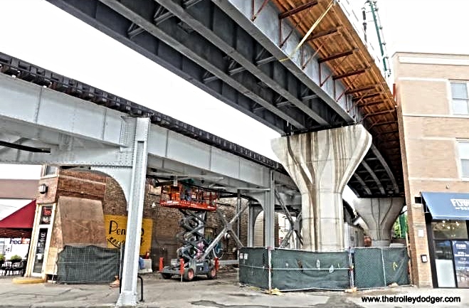


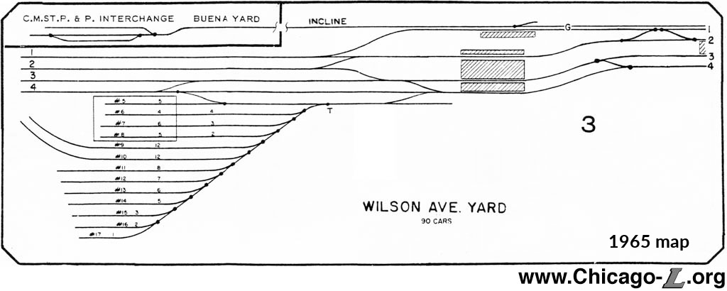 West of the Redline (Howard Line) were the tracks & yard for the Evanston branch of the Chicago, Milwaukee, & St. Paul. This railroad cut through Lake View like a knife with factories and homes constructed around it since its construction in the last quarter of the 19th century. This line was meant for freight only while the elevated was designed for commuters.


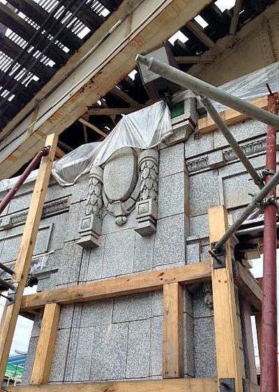


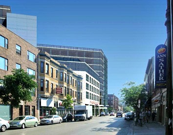


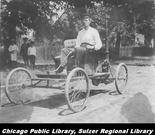


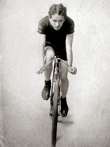


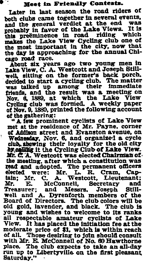


.jpg)
.jpg)

.jpg)

No comments:
Post a Comment